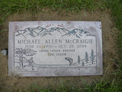
Michael Allen McCraigie
| Birth | : | 23 Jun 1970 Brewster, Okanogan County, Washington, USA |
| Death | : | 29 Oct 2009 Spokane, Spokane County, Washington, USA |
| Burial | : | Eikenberry Cemetery, Wheatville, Preble County, USA |
| Coordinate | : | 39.6852760, -84.5749969 |
| Description | : | Wenatchee World - Saturday, October 31, 2009 Michael A. McCraigie, 39 of Omak, died Thursday, Oct. 29, 2009, at Deaconess Medical Center in Spokane. He worked as a lumber grader for an Omak mill for the last several years. Rosary was recited Friday and a funeral Mass was celebrated Saturday at the Omak Longhouse in Omak. A burial service followed the funeral at the Fort Okanogan Cemetery in Monse. Arrangements are by Precht-Harrison-Nearents Chapel, Okanogan. |
frequently asked questions (FAQ):
-
Where is Michael Allen McCraigie's memorial?
Michael Allen McCraigie's memorial is located at: Eikenberry Cemetery, Wheatville, Preble County, USA.
-
When did Michael Allen McCraigie death?
Michael Allen McCraigie death on 29 Oct 2009 in Spokane, Spokane County, Washington, USA
-
Where are the coordinates of the Michael Allen McCraigie's memorial?
Latitude: 39.6852760
Longitude: -84.5749969
Family Members:
Parent
Flowers:
Nearby Cemetories:
1. Eikenberry Cemetery
Wheatville, Preble County, USA
Coordinate: 39.6852760, -84.5749969
2. Camp Run Cemetery
Wheatville, Preble County, USA
Coordinate: 39.6758347, -84.6083298
3. United Brethren Cemetery
Wheatville, Preble County, USA
Coordinate: 39.6833610, -84.5316390
4. Flory Graveyard
Gratis, Preble County, USA
Coordinate: 39.6500790, -84.5761330
5. Lower Twin Old German Baptist Brethren Cemetery
Gratis, Preble County, USA
Coordinate: 39.6489260, -84.5773920
6. Ray Cemetery
Gratis, Preble County, USA
Coordinate: 39.6575539, -84.5427273
7. Clemmer Cemetery
Enterprise, Preble County, USA
Coordinate: 39.7050740, -84.5338730
8. Young Family Cemetery
Gratis, Preble County, USA
Coordinate: 39.6573200, -84.5427770
9. Fisher Cemetery
West Alexandria, Preble County, USA
Coordinate: 39.7267200, -84.5760600
10. Willson Cemetery
Ingomar, Preble County, USA
Coordinate: 39.7042150, -84.5252040
11. Phillips Cemetery
Gratis, Preble County, USA
Coordinate: 39.6508798, -84.5385558
12. Antioch Cemetery
Eaton, Preble County, USA
Coordinate: 39.7000008, -84.6318970
13. Fairview Cemetery
Gratis, Preble County, USA
Coordinate: 39.6500015, -84.5361023
14. Swinehart Cemetery
Preble County, USA
Coordinate: 39.6750970, -84.5149000
15. Brower Cemetery
West Alexandria, Preble County, USA
Coordinate: 39.7287750, -84.5473480
16. Campbell Cemetery
Eaton, Preble County, USA
Coordinate: 39.7172740, -84.6224530
17. Gratis Cemetery
Gratis, Preble County, USA
Coordinate: 39.6489470, -84.5308220
18. Davis Graveyard
Camden, Preble County, USA
Coordinate: 39.6384720, -84.6115290
19. Davis Cemetery
Camden, Preble County, USA
Coordinate: 39.6333792, -84.5974460
20. Kirven-Pottenger Cemetery
Camden, Preble County, USA
Coordinate: 39.6475500, -84.6266200
21. Fisher Cemetery
Eaton, Preble County, USA
Coordinate: 39.7289400, -84.6185600
22. Sample-Stover Cemetery
Sampleville, Preble County, USA
Coordinate: 39.7417870, -84.5708070
23. Van Ausdal Cemetery
West Alexandria, Preble County, USA
Coordinate: 39.7295620, -84.5281930
24. Brower Cemetery
Enterprise, Preble County, USA
Coordinate: 39.6789200, -84.4991970


