
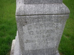
| Birth | : | 8 Dec 1868 Linn County, Iowa, USA |
| Death | : | 29 Mar 1948 Hancock County, Iowa, USA |
| Burial | : | Saint James Cemetery, Clare, Webster County, USA |
| Coordinate | : | 42.5691986, -94.3644028 |
frequently asked questions (FAQ):
-
Where is Michael Charles “Mike” Gahan's memorial?
Michael Charles “Mike” Gahan's memorial is located at: Saint James Cemetery, Clare, Webster County, USA.
-
When did Michael Charles “Mike” Gahan death?
Michael Charles “Mike” Gahan death on 29 Mar 1948 in Hancock County, Iowa, USA
-
Where are the coordinates of the Michael Charles “Mike” Gahan's memorial?
Latitude: 42.5691986
Longitude: -94.3644028
Family Members:
Parent

Spouse
Siblings
Children
Flowers:


Nearby Cemetories:
1. Saint James Cemetery
Clare, Webster County, USA
Coordinate: 42.5691986, -94.3644028
2. Jackson Center Cemetery
Clare, Webster County, USA
Coordinate: 42.5783005, -94.3741989
3. Saint Josephs Cemetery
Barnum, Webster County, USA
Coordinate: 42.5172000, -94.3769000
4. Old Lizard Cemetery
Webster County, USA
Coordinate: 42.5249720, -94.3141340
5. Saint Patricks Cemetery
Clare, Webster County, USA
Coordinate: 42.5943985, -94.4419022
6. Burns Cemetery
Webster County, USA
Coordinate: 42.5249970, -94.2759880
7. Trinity Lutheran Cemetery
Webster County, USA
Coordinate: 42.5875015, -94.2581024
8. Lizard Cemetery
Palmer, Pocahontas County, USA
Coordinate: 42.5875015, -94.4796982
9. Calvary Presbyterian Cemetery
Barnum, Webster County, USA
Coordinate: 42.4742810, -94.3835020
10. Willowledge Cemetery
Fort Dodge, Webster County, USA
Coordinate: 42.5250015, -94.2388916
11. Our Saviors Cemetery
Humboldt County, USA
Coordinate: 42.6596985, -94.2956009
12. Trinity Cemetery
Calhoun County, USA
Coordinate: 42.4747200, -94.4555588
13. Concordia Cemetery
Fort Dodge, Webster County, USA
Coordinate: 42.5628014, -94.1949997
14. Rose Hill Cemetery
Manson, Calhoun County, USA
Coordinate: 42.5228004, -94.5243988
15. Carpenter Cemetery
Webster County, USA
Coordinate: 42.5015907, -94.2166061
16. Saint Johns Lutheran Cemetery
Palmer, Pocahontas County, USA
Coordinate: 42.6268997, -94.5205994
17. Saint Olafs Cemetery
Fort Dodge, Webster County, USA
Coordinate: 42.5017014, -94.2153015
18. Saint Paul Lutheran Cemetery
Pocahontas County, USA
Coordinate: 42.5610000, -94.5392000
19. Our Lady of Good Counsel Cemetery
Moorland, Webster County, USA
Coordinate: 42.4427986, -94.3043976
20. Hope Cemetery
Manson, Calhoun County, USA
Coordinate: 42.4994011, -94.5199966
21. Saint Thomas Cemetery
Manson, Calhoun County, USA
Coordinate: 42.5208500, -94.5365000
22. Greenfield Cemetery
Knierim, Calhoun County, USA
Coordinate: 42.4495000, -94.4565000
23. Fulton Lutheran Cemetery
Roelyn, Webster County, USA
Coordinate: 42.4263992, -94.3688965
24. Corpus Christi Cemetery
Fort Dodge, Webster County, USA
Coordinate: 42.5243988, -94.1802979