
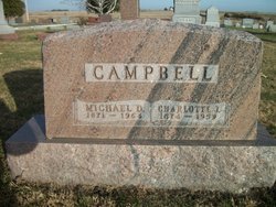
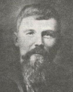
Michael DeLoss Campbell
| Birth | : | 14 Sep 1871 |
| Death | : | 21 Apr 1964 |
| Burial | : | Hattfjelldal, Hattfjelldal, Hattfjelldal kommune, Norway |
| Coordinate | : | 65.5968740, 13.9913680 |
| Description | : | Husband of Charlotte J. Campbell Buried next to son Guy F. Campbell |
frequently asked questions (FAQ):
-
Where is Michael DeLoss Campbell's memorial?
Michael DeLoss Campbell's memorial is located at: Hattfjelldal, Hattfjelldal, Hattfjelldal kommune, Norway.
-
When did Michael DeLoss Campbell death?
Michael DeLoss Campbell death on 21 Apr 1964 in
-
Where are the coordinates of the Michael DeLoss Campbell's memorial?
Latitude: 65.5968740
Longitude: 13.9913680
Family Members:

Spouse

Siblings
Children


Flowers:


Nearby Cemetories:
1. Hattfjelldal
Hattfjelldal, Hattfjelldal kommune, Norway
Coordinate: 65.5968740, 13.9913680
2. Susendal Church Cemetery
Hattfjelldal, Hattfjelldal kommune, Norway
Coordinate: 65.5970770, 13.9921910
3. Grane Church
Grane kommune, Norway
Coordinate: 65.5831210, 13.3967580
4. Krokselmoen
Hemnes kommune, Norway
Coordinate: 65.9500977, 13.7985281
5. Mosjøen Kapell Cemetery
Mosjoen, Vefsn kommune, Norway
Coordinate: 65.8389587, 13.2066603
6. Dolstad Kirke
Mosjoen, Vefsn kommune, Norway
Coordinate: 65.8449360, 13.2035590
7. Korgen Nye Kirkegård
Korgen, Hemnes kommune, Norway
Coordinate: 66.0765930, 13.8247170
8. Korgen øvre Kirkegård
Korgen, Hemnes kommune, Norway
Coordinate: 66.0769530, 13.8261220
9. Korgen nedre kirkegård
Korgen, Hemnes kommune, Norway
Coordinate: 66.0775500, 13.8278600
10. Bjerka øvre
Bjerka, Hemnes kommune, Norway
Coordinate: 66.1540260, 13.8576180
11. Visthus
Visthus, Vevelstad kommune, Norway
Coordinate: 65.7326960, 12.5933830
12. Vevelstad Kirke
Vevelstad, Vevelstad kommune, Norway
Coordinate: 65.7089000, 12.4551000
13. Hemnes Cemetery
Hemnesberget, Hemnes kommune, Norway
Coordinate: 66.2277860, 13.6164320
14. Sandnes kirkegård
Sandnessjoen, Alstahaug kommune, Norway
Coordinate: 66.0140735, 12.6260426
15. Tjøtta Soviet War Cemetery
Tjotta, Alstahaug kommune, Norway
Coordinate: 65.8453476, 12.3938890
16. Mo I Rana Churchyard
Mo i Rana, Rana kommune, Norway
Coordinate: 66.3099600, 14.1436480
17. Nesna kirkegard
Nesna, Nesna kommune, Norway
Coordinate: 66.1999100, 13.0364200
18. Alstahaug Church Cemetery
Alstahaug, Alstahaug kommune, Norway
Coordinate: 65.8935110, 12.3991990
19. Nesna ved kirken
Nesna, Nesna kommune, Norway
Coordinate: 66.2005552, 13.0251207
20. Ytteren
Rana kommune, Norway
Coordinate: 66.3458870, 14.1294110
21. Ylvingen kirkegård
Ylvingen, Vega kommune, Norway
Coordinate: 65.6369834, 12.1702984
22. Løkta gravplass
Nesna kommune, Norway
Coordinate: 66.1776443, 12.7274176
23. Bjørhusdal kapell kirkegård
Bjorhusdalen, Namsskogan kommune, Norway
Coordinate: 64.9188720, 13.0786195
24. Aust-Tomma hjelpekirkegård
Nesna kommune, Norway
Coordinate: 66.2395028, 12.8554883