
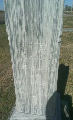
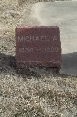
Michael E. Hargleroad
| Birth | : | 18 Nov 1824 Guilford Springs, Franklin County, Pennsylvania, USA |
| Death | : | 22 Aug 1904 Holstein, Adams County, Nebraska, USA |
| Burial | : | Holstein Cemetery, Holstein, Adams County, USA |
| Coordinate | : | 40.4660988, -98.6378021 |
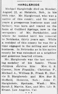
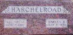
| Description | : | Michael E. Hargleroad, the son of John and wife Elizabeth Etter Hargleroad, was born in Guilford Township, Franklin County, Pennsylvania on November 18, 1824. He married Elizabeth Brough there in 1849. They raised a family of ten children. In 1874, Michael and his family migrated first to Huntington, Indiana, then in the same year, to Cottonwood Township, Adams County, Nebraska, where they made their home. Michael Hargleroad, a farmer and stock raiser, owned a 320 acre farm about one mile from Holstein, Adams County, Nebraska. |
frequently asked questions (FAQ):
-
Where is Michael E. Hargleroad's memorial?
Michael E. Hargleroad's memorial is located at: Holstein Cemetery, Holstein, Adams County, USA.
-
When did Michael E. Hargleroad death?
Michael E. Hargleroad death on 22 Aug 1904 in Holstein, Adams County, Nebraska, USA
-
Where are the coordinates of the Michael E. Hargleroad's memorial?
Latitude: 40.4660988
Longitude: -98.6378021
Family Members:
Parent
Spouse
Siblings
Children

Flowers:


Nearby Cemetories:
1. Holstein Cemetery
Holstein, Adams County, USA
Coordinate: 40.4660988, -98.6378021
2. Saint Pauls Lutheran Cemetery
Holstein, Adams County, USA
Coordinate: 40.4667400, -98.6568700
3. West Ward Cemetery
Holstein, Adams County, USA
Coordinate: 40.4805984, -98.6857986
4. Roseland Cemetery
Roseland, Adams County, USA
Coordinate: 40.4622002, -98.5736008
5. Zion Lutheran Cemetery
Wanda Township, Adams County, USA
Coordinate: 40.5340540, -98.6286260
6. Assumption Cemetery
Assumption, Adams County, USA
Coordinate: 40.5103500, -98.5692500
7. Silver Lake Cemetery
Roseland, Adams County, USA
Coordinate: 40.4522018, -98.5425034
8. Logan Cemetery
Adams County, USA
Coordinate: 40.3927994, -98.6658020
9. Morseville Cemetery
Adams County, USA
Coordinate: 40.3941994, -98.6996994
10. Roseland Mennonite Cemetery
Roseland, Adams County, USA
Coordinate: 40.4411011, -98.5164032
11. Shiloh Cemetery
Adams County, USA
Coordinate: 40.5525017, -98.7050018
12. Norman Cemetery
Norman, Kearney County, USA
Coordinate: 40.4728012, -98.7992020
13. Mount Pleasant Cemetery
Adams County, USA
Coordinate: 40.4961014, -98.4788971
14. Saxour Cemetery
Ayr, Adams County, USA
Coordinate: 40.3940700, -98.4867600
15. May Cemetery
Norman, Kearney County, USA
Coordinate: 40.4599991, -98.8191986
16. Kenesaw Cemetery
Kenesaw, Adams County, USA
Coordinate: 40.6035995, -98.6603012
17. Harmony Cemetery
Bladen, Webster County, USA
Coordinate: 40.3218994, -98.6605988
18. Juniata Cemetery
Juniata, Adams County, USA
Coordinate: 40.5889015, -98.5286026
19. Immanuel Lutheran Church Cemetery
Ayr, Adams County, USA
Coordinate: 40.5247870, -98.4583300
20. East Lawn Cemetery
Bladen, Webster County, USA
Coordinate: 40.3208008, -98.5886002
21. Eaton Cemetery
Heartwell, Kearney County, USA
Coordinate: 40.5614014, -98.8003006
22. Holy Family Cemetery
Heartwell, Kearney County, USA
Coordinate: 40.5960999, -98.7605972
23. Osco Cemetery
Kearney County, USA
Coordinate: 40.3725014, -98.8118973
24. Campbell Cemetery
Webster County, USA
Coordinate: 40.3064570, -98.7220340