Michael Flynn
| Birth | : | 25 Dec 1840 Ireland |
| Death | : | 3 Jul 1911 Coggon, Linn County, Iowa, USA |
| Burial | : | Forest Grove Cemetery, Tenino, Thurston County, USA |
| Coordinate | : | 46.8254580, -122.8497110 |
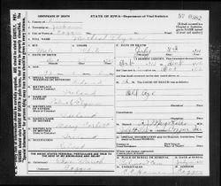
| Description | : | 1870 census - age 30 1880 census - age 45 1885 census - age 48 1895 census - age 65 1900 census - age 79 1910 census - age 93 Death record - born Dec 25, 1804 |
frequently asked questions (FAQ):
-
Where is Michael Flynn's memorial?
Michael Flynn's memorial is located at: Forest Grove Cemetery, Tenino, Thurston County, USA.
-
When did Michael Flynn death?
Michael Flynn death on 3 Jul 1911 in Coggon, Linn County, Iowa, USA
-
Where are the coordinates of the Michael Flynn's memorial?
Latitude: 46.8254580
Longitude: -122.8497110
Family Members:
Spouse
Children
Flowers:
Nearby Cemetories:
1. Forest Grove Cemetery
Tenino, Thurston County, USA
Coordinate: 46.8254580, -122.8497110
2. Cogdil Family Cemetery
Thurston County, USA
Coordinate: 46.7747010, -122.8826590
3. Grand Mound Cemetery
Rochester, Thurston County, USA
Coordinate: 46.8213997, -123.0199966
4. Greenwood Memorial Park
Centralia, Lewis County, USA
Coordinate: 46.7372017, -122.9824982
5. Washington Lawn Cemetery
Centralia, Lewis County, USA
Coordinate: 46.7209320, -122.9606040
6. Thurston County Poor Farm Cemetery
Littlerock, Thurston County, USA
Coordinate: 46.8861790, -123.0225100
7. Mountain View Cemetery
Centralia, Lewis County, USA
Coordinate: 46.7289009, -122.9843979
8. Pioneer Cemetery
Centralia, Lewis County, USA
Coordinate: 46.7290300, -122.9898100
9. Rainier Cemetery
Rainier, Thurston County, USA
Coordinate: 46.8983500, -122.6771300
10. Mima Prairie Pioneer Cemetery
Mima, Thurston County, USA
Coordinate: 46.8724403, -123.0611649
11. Deskins Family Cemetery
Chehalis, Lewis County, USA
Coordinate: 46.6878000, -122.7530000
12. Union Cemetery
Tumwater, Thurston County, USA
Coordinate: 46.9954410, -122.9215700
13. Pioneer Calvary Catholic Cemetery
Tumwater, Thurston County, USA
Coordinate: 46.9951280, -122.9233700
14. Mills and Mills Memorial Park
Tumwater, Thurston County, USA
Coordinate: 46.9956800, -122.9214230
15. Greenwood Cemetery
Chehalis, Lewis County, USA
Coordinate: 46.6511002, -122.9389038
16. Woodlawn Cemetery
Lacey, Thurston County, USA
Coordinate: 47.0088692, -122.8046875
17. Ruddell Pioneer Cemetery
Lacey, Thurston County, USA
Coordinate: 47.0093613, -122.8083572
18. Laramie Family Cemetery
Thurston County, USA
Coordinate: 46.8376202, -122.5778103
19. Calvary Catholic Cemetery
Tumwater, Thurston County, USA
Coordinate: 47.0126250, -122.8925620
20. Delphi Pioneer Cemetery
Olympia, Thurston County, USA
Coordinate: 46.9675827, -123.0344009
21. Odd Fellows Memorial Park and Mausoleum
Tumwater, Thurston County, USA
Coordinate: 47.0138397, -122.8980865
22. Temple Beth Hatfiloh Cemetery
Tumwater, Thurston County, USA
Coordinate: 47.0143738, -122.8958206
23. Masonic Memorial Park
Tumwater, Thurston County, USA
Coordinate: 47.0160141, -122.8963242
24. Schmidt Family Cemetery
Tumwater, Thurston County, USA
Coordinate: 47.0183601, -122.9023209

