
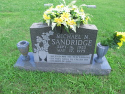


Michael Noel Sandridge
| Birth | : | 16 Sep 1953 USA |
| Death | : | 17 May 1975 USA |
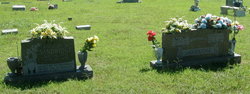
| Burial | : | Arytown Cemetery, Arytown, Oregon County, USA |
| Coordinate | : | 36.5539513, -91.3795776 |
| Description | : | A1C US Air Force |
frequently asked questions (FAQ):
-
Where is Michael Noel Sandridge's memorial?
Michael Noel Sandridge's memorial is located at: Arytown Cemetery, Arytown, Oregon County, USA.
-
When did Michael Noel Sandridge death?
Michael Noel Sandridge death on 17 May 1975 in USA
-
Where are the coordinates of the Michael Noel Sandridge's memorial?
Latitude: 36.5539513
Longitude: -91.3795776
Family Members:
Parent

Flowers:


Nearby Cemetories:
1. Arytown Cemetery
Arytown, Oregon County, USA
Coordinate: 36.5539513, -91.3795776
2. Russell Cemetery
Couch, Oregon County, USA
Coordinate: 36.5506477, -91.3991928
3. Olon Tucker Farm Cemetery #2
Couch, Oregon County, USA
Coordinate: 36.5867000, -91.3705400
4. New Salem Cemetery
Couch, Oregon County, USA
Coordinate: 36.6042252, -91.3712463
5. Rose Hill Cemetery
Thayer, Oregon County, USA
Coordinate: 36.5186386, -91.4263763
6. Guiteau-Risner Cemetery
Guiteau, Oregon County, USA
Coordinate: 36.5588074, -91.3156128
7. Garfield Cemetery
Garfield, Oregon County, USA
Coordinate: 36.5844400, -91.3253400
8. Adolph Ostrom Farm Cemetery
Thayer, Oregon County, USA
Coordinate: 36.5788160, -91.4426640
9. Crass Homestead
Myrtle, Oregon County, USA
Coordinate: 36.5359695, -91.3084671
10. Crabb Cemetery
Couch, Oregon County, USA
Coordinate: 36.5988541, -91.4339752
11. Bonds Cemetery
Couch, Oregon County, USA
Coordinate: 36.5989914, -91.4346619
12. Byrd Cemetery
Myrtle, Oregon County, USA
Coordinate: 36.5186005, -91.3143997
13. Baker Cemetery
Couch, Oregon County, USA
Coordinate: 36.6248283, -91.3932877
14. John Brown Cemetery
Jobe, Oregon County, USA
Coordinate: 36.5812111, -91.2953568
15. Pleasant Ridge Cemetery
Sharp County, USA
Coordinate: 36.4876710, -91.4221830
16. Davis Cemetery
Thayer, Oregon County, USA
Coordinate: 36.5339508, -91.4751358
17. Jeff Cemetery
Jeff, Oregon County, USA
Coordinate: 36.5256166, -91.4746129
18. Union Hill Cemetery
Brandsville, Howell County, USA
Coordinate: 36.5256341, -91.4746829
19. Norman Cemetery
Alton, Oregon County, USA
Coordinate: 36.6143990, -91.4499969
20. Buehler Farm Cemetery
Clifton, Oregon County, USA
Coordinate: 36.5639496, -91.4845810
21. James Cemetery
Randolph County, USA
Coordinate: 36.4660988, -91.3435974
22. Midway Cemetery
Couch, Oregon County, USA
Coordinate: 36.6031690, -91.4788520
23. Davis Cemetery
Sharp County, USA
Coordinate: 36.4606018, -91.3574982
24. Cave Springs Cemetery #2
Alton, Oregon County, USA
Coordinate: 36.6488900, -91.3652900