
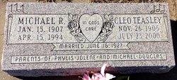
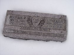

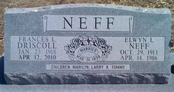
Michael R Driscoll
| Birth | : | 15 Jan 1907 Glasco, Cloud County, Kansas, USA |
| Death | : | 15 Apr 1994 Beloit, Mitchell County, Kansas, USA |
| Burial | : | Brookside Cemetery, Bridgewater, Lunenburg County, Canada |
| Coordinate | : | 44.3819400, -64.5285800 |
| Plot | : | 2SE1 |
| Inscription | : | Married June 16, 1927 |
| Description | : | Salina Journal – Apr. 17, 1994 GLASCO—Michael R. Driscoll, 87, Glasco, died Friday, April 15, 1994, at the Mitchell County Hospital, Beloit. Mr. Driscoll was born Jan. 15, 1907, northeast of Glasco, and was a lifelong area resident. He was a farmer and stockman, and a member of the New Hope Wesleyan Church. He was preceded in death by a son, Michael "Mickey," in 1982. Survivors include his wife, Cleo of the home; a daughter, Jolene Norton of Syracuse; two sisters, Sylvia Everley and Frances Neff, both of Glasco; six grandchildren; three step-grandchildren; and 13 great-grandchildren. The funeral will be at 2 p.m. Monday at... Read More |
frequently asked questions (FAQ):
-
Where is Michael R Driscoll's memorial?
Michael R Driscoll's memorial is located at: Brookside Cemetery, Bridgewater, Lunenburg County, Canada.
-
When did Michael R Driscoll death?
Michael R Driscoll death on 15 Apr 1994 in Beloit, Mitchell County, Kansas, USA
-
Where are the coordinates of the Michael R Driscoll's memorial?
Latitude: 44.3819400
Longitude: -64.5285800
Family Members:
Parent

Spouse

Siblings
Children

Flowers:


Nearby Cemetories:
1. Brookside Cemetery
Bridgewater, Lunenburg County, Canada
Coordinate: 44.3819400, -64.5285800
2. Saint Joseph's Catholic Cemetery
Bridgewater, Lunenburg County, Canada
Coordinate: 44.3785600, -64.5303900
3. Holy Trinity Anglican Cemetery
Bridgewater, Lunenburg County, Canada
Coordinate: 44.3726110, -64.5000000
4. Hebbville Cemetery
Hebbville, Lunenburg County, Canada
Coordinate: 44.3510700, -64.5384600
5. Dayspring Community Cemetery
Dayspring, Lunenburg County, Canada
Coordinate: 44.3730300, -64.4808200
6. Maple Leaf Cemetery
Conquerall Bank, Lunenburg County, Canada
Coordinate: 44.3647900, -64.4756700
7. Redeemer Lutheran Church Cemetery
Conquerall Bank, Lunenburg County, Canada
Coordinate: 44.3609139, -64.4577333
8. Acacia Cemetery
Conquerall Bank, Lunenburg County, Canada
Coordinate: 44.3586110, -64.4566670
9. Newcombville Cemetery
Newcombville, Lunenburg County, Canada
Coordinate: 44.3752200, -64.6074600
10. Christ Anglican Church Cemetery
Maitland, Lunenburg County, Canada
Coordinate: 44.4312900, -64.4799300
11. Pleasantville Cemetery New
Pleasantville, Lunenburg County, Canada
Coordinate: 44.3372600, -64.4499600
12. Lake Centre Cemetery
Lake Centre, Lunenburg County, Canada
Coordinate: 44.3142200, -64.4834800
13. Silver Cemetery - Rhodes Corner
Rhodes Corner, Lunenburg County, Canada
Coordinate: 44.3776400, -64.4228700
14. Oakhill Cemetery
Conquerall Mills, Lunenburg County, Canada
Coordinate: 44.3058333, -64.5327777
15. Saint James Anglican Cemetery
Conquerall Mills, Lunenburg County, Canada
Coordinate: 44.3058333, -64.5327777
16. Old Pleasantville Cemetery - Pleasantville
Pleasantville, Lunenburg County, Canada
Coordinate: 44.3358800, -64.4394300
17. Pleasantville Cemetery Old
Pleasantville, Lunenburg County, Canada
Coordinate: 44.3355170, -64.4395810
18. Conquerall Mills Lutheran Church Cemetery
Conquerall Mills, Lunenburg County, Canada
Coordinate: 44.3022220, -64.5413880
19. Saint Matthew's Presbyterian Cemetery
Conquerall Mills, Lunenburg County, Canada
Coordinate: 44.3019440, -64.5419440
20. Mulock Cemetery
Rhodes Corner, Lunenburg County, Canada
Coordinate: 44.3675510, -64.4166670
21. Midville Branch Cemetery
Midville Branch, Lunenburg County, Canada
Coordinate: 44.4215800, -64.6320500
22. Sweetland Cemetery
Sweetland, Lunenburg County, Canada
Coordinate: 44.4682400, -64.5079200
23. Middle LaHave Cemetery
Middle LaHave, Lunenburg County, Canada
Coordinate: 44.3308500, -64.4213000
24. Farmville Cemetery
Farmville, Lunenburg County, Canada
Coordinate: 44.4649900, -64.4690100