
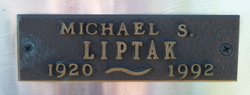

Michael Stephen Liptak
| Birth | : | 20 Feb 1920 Hardieville, Lethbridge Census Division, Alberta, Canada |
| Death | : | 25 Aug 1992 Claresholm, Claresholm Census Division, Alberta, Canada |
| Burial | : | Stavely Cemetery Cremation Cairn, Stavely, Claresholm Census Division, Canada |
| Coordinate | : | 50.1646700, -113.6625600 |
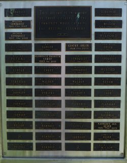
| Inscription | : | "THIS RECORD IS IN MEMORY OF THOSE CITIZENS OF THE COMMUNITY WHOSE CREMAINS ARE RESTING ELSEWHERE" |
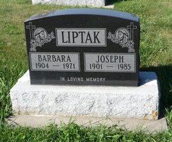
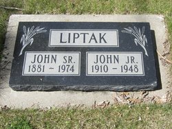
| Description | : | Lethbridge Herald August 27, 1992 LIPTAK MICHAEL STEPHEN, passed away at the Claresholm General Hospital on Tuesday, August 25, 1992 at the age of 72 years, beloved husband of Doreen (Clark) Liptak of Stavely. Mike was born at Hardieville, Alberta on February 20, 1920. He joined the Armed Forces in 1940 and served overseas until 1945. He was Postmaster at Barons and retired to Stavely after 30 years of service. Mike was predeceased by his parents; brothers: John, Joseph, Paul and Steve and a brother-in-law, Julius Toth. |
frequently asked questions (FAQ):
-
Where is Michael Stephen Liptak's memorial?
Michael Stephen Liptak's memorial is located at: Stavely Cemetery Cremation Cairn, Stavely, Claresholm Census Division, Canada.
-
When did Michael Stephen Liptak death?
Michael Stephen Liptak death on 25 Aug 1992 in Claresholm, Claresholm Census Division, Alberta, Canada
-
Where are the coordinates of the Michael Stephen Liptak's memorial?
Latitude: 50.1646700
Longitude: -113.6625600
Family Members:
Parent

Spouse

Siblings
Flowers:


Nearby Cemetories:
1. Stavely Cemetery
Stavely, Claresholm Census Division, Canada
Coordinate: 50.1646700, -113.6625600
2. Stavely Cemetery Cremation Cairn
Stavely, Claresholm Census Division, Canada
Coordinate: 50.1646700, -113.6625600
3. Saint Vincent Roman Catholic Cemetery
Stavely, Claresholm Census Division, Canada
Coordinate: 50.1717670, -113.6409830
4. Claresholm Cemetery
Claresholm, Claresholm Census Division, Canada
Coordinate: 50.0114784, -113.5946503
5. Saint Peter's Lutheran Cemetery
Claresholm, Claresholm Census Division, Canada
Coordinate: 50.0487620, -113.4822460
6. Nanton Town Cemetery
Nanton, Claresholm Census Division, Canada
Coordinate: 50.3333800, -113.7586100
7. Five Mile Cemetery
Claresholm, Claresholm Census Division, Canada
Coordinate: 50.0188250, -113.4705730
8. Little Bow Hutterite Cemetery
Stavely, Claresholm Census Division, Canada
Coordinate: 50.2142141, -113.3694417
9. St. Cecilia's Roman Catholic Cemetery
Nanton, Claresholm Census Division, Canada
Coordinate: 50.3588000, -113.7591600
10. Fath Hill Catholic Cemetery
Champion, Strathmore Census Division, Canada
Coordinate: 50.2153400, -113.2544200
11. Alston Cemetery
Vulcan, Strathmore Census Division, Canada
Coordinate: 50.1652820, -113.2450470
12. Isol Russell Grave
Champion, Strathmore Census Division, Canada
Coordinate: 50.1792300, -113.2102100
13. Sharon Cemetery
Brant, Strathmore Census Division, Canada
Coordinate: 50.4555300, -113.5740800
14. Granum Cemetery
Granum, Claresholm Census Division, Canada
Coordinate: 49.8812800, -113.5251600
15. Elinor Cemetery
Barons, Lethbridge Census Division, Canada
Coordinate: 50.0271520, -113.2340240
16. Cayley Hutterite Cemetery
Cayley, Calgary Census Division, Canada
Coordinate: 50.4262264, -113.9245464
17. Granum Hutterite Cemetery
Granum, Claresholm Census Division, Canada
Coordinate: 49.8513248, -113.6038772
18. Cayley Cemetery
Cayley, Calgary Census Division, Canada
Coordinate: 50.4554130, -113.8556950
19. High River Hutterite Cemetery
High River, Calgary Census Division, Canada
Coordinate: 50.4816260, -113.6618863
20. Carmangay Cemetery
Carmangay, Strathmore Census Division, Canada
Coordinate: 50.1214300, -113.1434300
21. Cleverville Cemetery
Champion, Strathmore Census Division, Canada
Coordinate: 50.2736100, -113.1661700
22. Champion Cemetery
Champion, Strathmore Census Division, Canada
Coordinate: 50.2329200, -113.1441800
23. Vulcan Cemetery
Vulcan, Strathmore Census Division, Canada
Coordinate: 50.4032200, -113.2774100
24. Brant Cemetery
Brant, Strathmore Census Division, Canada
Coordinate: 50.5067400, -113.5068000