

Micheal “Mike” Spiker
| Birth | : | 10 Jan 1949 Holton, Jackson County, Kansas, USA |
| Death | : | 7 Sep 2017 Topeka, Shawnee County, Kansas, USA |
| Burial | : | Wetmore Cemetery, Wetmore, Nemaha County, USA |
| Coordinate | : | 39.6396800, -95.8108400 |
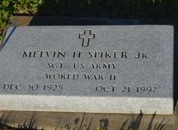
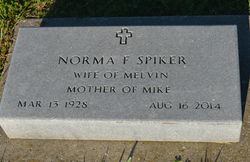
| Description | : | Micheal Spiker, 68, of Wetmore, KS passed away Thursday, September 7, 2017 at Stormont Vail Hospital. He was born January 10, 1949 in Holton, KS the son of Melvin “Pete” and Norma (Grubb) Spiker. Micheal graduated from Wetmore High School in 1968. He worked as a welder for Rockwell International in Atchison, KS for over 18 years. He was a member of the Wetmore United Methodist Church. He married Sharon A. Swanson on December 23, 1998 in Hiawatha, KS, she survives of the home. Other survivors include his 8 children Jamie Spiker of Olathe, Jared Spiker (Amy) of Holton, KS, Paula Henry (Alan)... Read More |
frequently asked questions (FAQ):
-
Where is Micheal “Mike” Spiker's memorial?
Micheal “Mike” Spiker's memorial is located at: Wetmore Cemetery, Wetmore, Nemaha County, USA.
-
When did Micheal “Mike” Spiker death?
Micheal “Mike” Spiker death on 7 Sep 2017 in Topeka, Shawnee County, Kansas, USA
-
Where are the coordinates of the Micheal “Mike” Spiker's memorial?
Latitude: 39.6396800
Longitude: -95.8108400
Family Members:
Parent
Siblings

Flowers:


Nearby Cemetories:
1. Wetmore Cemetery
Wetmore, Nemaha County, USA
Coordinate: 39.6396800, -95.8108400
2. Wolfley Cemetery
Goff, Nemaha County, USA
Coordinate: 39.6454400, -95.8633900
3. South Powhattan Cemetery
Powhattan, Brown County, USA
Coordinate: 39.6608009, -95.7596970
4. Netawaka Cemetery
Netawaka, Jackson County, USA
Coordinate: 39.6075300, -95.7223700
5. Pleasant Grove Cemetery
Jackson County, USA
Coordinate: 39.5664000, -95.7789000
6. Barnes Cemetery
Goff, Nemaha County, USA
Coordinate: 39.6960983, -95.8824997
7. Granada Cemetery
Granada, Nemaha County, USA
Coordinate: 39.7324982, -95.7988968
8. Ontario Cemetery
Nemaha County, USA
Coordinate: 39.5663795, -95.8885193
9. Fairview Cemetery
Goff, Nemaha County, USA
Coordinate: 39.6831017, -95.9383011
10. Grant-Mjessepe Cemetery
Horton, Brown County, USA
Coordinate: 39.6663000, -95.6576000
11. Comet Cemetery
Powhattan Township, Brown County, USA
Coordinate: 39.7542600, -95.7340400
12. Kennekuk Church Cemetery
Horton, Brown County, USA
Coordinate: 39.7074600, -95.6672300
13. Jessepe Indian Cemetery
Horton, Brown County, USA
Coordinate: 39.6715000, -95.6438000
14. Capioma Cemetery
Capioma, Nemaha County, USA
Coordinate: 39.7805099, -95.8205719
15. Carmel Cemetery
Circleville, Jackson County, USA
Coordinate: 39.4984400, -95.7967700
16. Circleville Cemetery
Circleville, Jackson County, USA
Coordinate: 39.5014000, -95.8664017
17. Pleasant Hill Cemetery
Corning, Nemaha County, USA
Coordinate: 39.6895800, -95.9907400
18. Grasshopper Burial Ground
Powhattan Township, Brown County, USA
Coordinate: 39.7578020, -95.6949820
19. Saint Augustine Catholic Cemetery
Capioma Township, Nemaha County, USA
Coordinate: 39.7904282, -95.7897034
20. Soldier Cemetery
Soldier, Jackson County, USA
Coordinate: 39.5417900, -95.9654800
21. Woodlawn Cemetery
Woodlawn, Nemaha County, USA
Coordinate: 39.7905998, -95.8638992
22. Spring Hill Cemetery
Whiting, Jackson County, USA
Coordinate: 39.6021996, -95.6121979
23. Jonach Cemetery
Nemaha County, USA
Coordinate: 39.7925700, -95.8646600
24. Saint Patricks Cemetery
Corning, Nemaha County, USA
Coordinate: 39.6521988, -96.0250015