

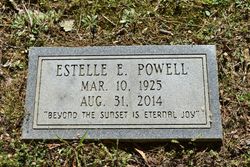
Mildred Estelle Everett Powell
| Birth | : | 10 Mar 1925 Washington County, North Carolina, USA |
| Death | : | 31 Aug 2014 Charlotte, Mecklenburg County, North Carolina, USA |
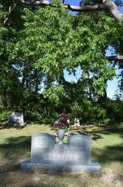
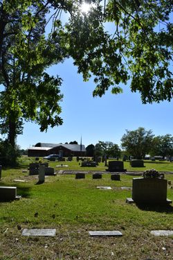
| Burial | : | Saints Delight Church of Christ Cemetery, Plymouth, Washington County, USA |
| Coordinate | : | 35.9094150, -76.6589470 |
| Description | : | Estelle Everett Spruill Powell, 89, of Roper died Sunday, August 31, 2014, at Carolina's Medical Center-Pineville in Charlotte. Born March 10, 1925 in Washington County she was the daughter of the late William Alfred Everett and Jessie Lloyd Phelps Everett and was preceded in death by her husbands, Marshall Joseph Spruill and Otha Francis Powell; sons, David Marshall Spruill and Stanley Wayne Spruill; brothers, Johnie Everett, James Everett, Cliff Everett and Herman Everett and two grandchildren. Mrs. Powell was a homemaker and member of Saint's Delight Church of Christ. Her family includes her daughters, Jean Howell and husband Dick of Rocky Mount,... Read More |
frequently asked questions (FAQ):
-
Where is Mildred Estelle Everett Powell's memorial?
Mildred Estelle Everett Powell's memorial is located at: Saints Delight Church of Christ Cemetery, Plymouth, Washington County, USA.
-
When did Mildred Estelle Everett Powell death?
Mildred Estelle Everett Powell death on 31 Aug 2014 in Charlotte, Mecklenburg County, North Carolina, USA
-
Where are the coordinates of the Mildred Estelle Everett Powell's memorial?
Latitude: 35.9094150
Longitude: -76.6589470
Family Members:
Parent

Spouse
Siblings


Children

Flowers:


Nearby Cemetories:
1. Saints Delight Church of Christ Cemetery
Plymouth, Washington County, USA
Coordinate: 35.9094150, -76.6589470
2. Bailey Swain Cemetery
Roper, Washington County, USA
Coordinate: 35.9102400, -76.6541110
3. First Zion Grove Missionary Baptist Church
Roper, Washington County, USA
Coordinate: 35.9046880, -76.6721360
4. Davis Cemetery
Lees Mill Township, Washington County, USA
Coordinate: 35.8975000, -76.6526300
5. Joseph W. Blount Cemetery
Roper, Washington County, USA
Coordinate: 35.9175420, -76.6439460
6. Woodlawn Cemetery
Roper, Washington County, USA
Coordinate: 35.8935400, -76.6552930
7. Davenport Family Plot
Roper, Washington County, USA
Coordinate: 35.8929800, -76.6503300
8. Fountain of Life Baptist Church Cemetery
Roper, Washington County, USA
Coordinate: 35.9190210, -76.6291450
9. Saint Luke Cemetery
Roper, Washington County, USA
Coordinate: 35.8967018, -76.6271973
10. Craft Family Cemetery
Roper, Washington County, USA
Coordinate: 35.9049050, -76.6230320
11. Tarkenton Cemetery
Roper, Washington County, USA
Coordinate: 35.8790700, -76.6540300
12. Griffin H. Cooper Cemetery
Lees Mill Township, Washington County, USA
Coordinate: 35.8791200, -76.6649200
13. Oliver Cemetery
Lees Mill Township, Washington County, USA
Coordinate: 35.8794810, -76.6461390
14. W. J. Mizelle Cemetery
Roper, Washington County, USA
Coordinate: 35.8766810, -76.6493930
15. Macedonia AME Zion Church Cemetery
Roper, Washington County, USA
Coordinate: 35.8757240, -76.6674800
16. Second Zion Grove Church Cemetery
Plymouth, Washington County, USA
Coordinate: 35.8949730, -76.6976000
17. Zions Chapel Church Cemetery
Roper, Washington County, USA
Coordinate: 35.8764870, -76.6420880
18. W. L. Robertson Cemetery
Lees Mill Township, Washington County, USA
Coordinate: 35.8763400, -76.6383500
19. Reid Cemetery
Plymouth, Washington County, USA
Coordinate: 35.8851880, -76.6941520
20. Alfred Blount Cemetery
Roper, Washington County, USA
Coordinate: 35.8989020, -76.6095290
21. John M. Bowen Cemetery
Plymouth Township, Washington County, USA
Coordinate: 35.8750970, -76.6918100
22. Davenport Family Cemetery
Mackeys, Washington County, USA
Coordinate: 35.9305950, -76.6118950
23. Christ Holiness Church Cemetery
Roper, Washington County, USA
Coordinate: 35.8807570, -76.6181670
24. Lincoln Memorial Cemetery
Roper, Washington County, USA
Coordinate: 35.8778760, -76.6209560