


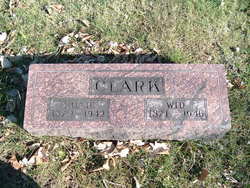
Mildred Hunnell Clark
| Birth | : | 27 Nov 1872 Jasper County, Iowa, USA |
| Death | : | 11 Oct 1942 New London, Henry County, Iowa, USA |
| Burial | : | Church of the Holy Cross Churhcyard, Caston, Breckland Borough, England |
| Coordinate | : | 52.5403040, 0.8876140 |
| Description | : | Millie was the daughter of Robert Hunnell and Mary Ann "Mollie" McCall. She married Wid Clark Mar. 21, 1894. They had nine children, Cloe, Blanche, Thomas, Victor, Orista, Winifred, Branson, Doris and Sherry. |
frequently asked questions (FAQ):
-
Where is Mildred Hunnell Clark's memorial?
Mildred Hunnell Clark's memorial is located at: Church of the Holy Cross Churhcyard, Caston, Breckland Borough, England.
-
When did Mildred Hunnell Clark death?
Mildred Hunnell Clark death on 11 Oct 1942 in New London, Henry County, Iowa, USA
-
Where are the coordinates of the Mildred Hunnell Clark's memorial?
Latitude: 52.5403040
Longitude: 0.8876140
Family Members:
Parent

Spouse
Siblings
Children
Flowers:


Nearby Cemetories:
1. Church of the Holy Cross Churhcyard
Caston, Breckland Borough, England
Coordinate: 52.5403040, 0.8876140
2. St Peter and St Paul Churchyard
Griston, Breckland Borough, England
Coordinate: 52.5569330, 0.8642500
3. St Margaret Churchyard
Breckles, Breckland Borough, England
Coordinate: 52.5139427, 0.8843616
4. St Peter Churchyard
Rocklands, Breckland Borough, England
Coordinate: 52.5350220, 0.9325260
5. St. Peter's Cemetery
Rockland St Peter, Breckland Borough, England
Coordinate: 52.5349241, 0.9327301
6. Holy Trinity Churchyard
Scoulton, Breckland Borough, England
Coordinate: 52.5706770, 0.9097190
7. All Saints Churchyard
Rocklands, Breckland Borough, England
Coordinate: 52.5253020, 0.9385050
8. St Peter's Churchyard
Merton, Breckland Borough, England
Coordinate: 52.5468460, 0.8181950
9. Saint Peter And Saint Paul Churchyard
Carbrooke, Breckland Borough, England
Coordinate: 52.5828170, 0.8763740
10. St. Peter's Churchyard
Little Ellingham, Breckland Borough, England
Coordinate: 52.5531500, 0.9560740
11. St. Peter & St. Paul Churchyard
Shropham, Breckland Borough, England
Coordinate: 52.4968770, 0.9217990
12. Holy Trinity Churchyard
Great Hockham, Breckland Borough, England
Coordinate: 52.4920650, 0.8717930
13. St. John the Evangelist Churchyard
Ovington, Breckland Borough, England
Coordinate: 52.5828096, 0.8454144
14. St. James Churchyard
Great Ellingham, Breckland Borough, England
Coordinate: 52.5347590, 0.9774180
15. Hingham Cemetery
Hingham, South Norfolk District, England
Coordinate: 52.5759750, 0.9773700
16. All Saints Churchyard
Snetterton, Breckland Borough, England
Coordinate: 52.4807600, 0.9350140
17. St. Mary's Churchyard
Cranworth, Breckland Borough, England
Coordinate: 52.6020260, 0.9269480
18. St. George's Parish Churchyard
Saham Toney, Breckland Borough, England
Coordinate: 52.5829900, 0.8020200
19. St. Andrew's Churchyard
Illington, Breckland Borough, England
Coordinate: 52.4731120, 0.8666610
20. St. Andrew's Churchyard
Hingham, South Norfolk District, England
Coordinate: 52.5791660, 0.9825900
21. St. Ethelbert's Churchyard
Larling, Breckland Borough, England
Coordinate: 52.4696000, 0.9170350
22. St Andrew Churchyard
Southburgh, Breckland Borough, England
Coordinate: 52.6041430, 0.9568180
23. All Saints Churchyard Hargham
Quideham, Breckland Borough, England
Coordinate: 52.4826470, 0.9732300
24. Attleborough Cemetery
Attleborough, Breckland Borough, England
Coordinate: 52.5206640, 1.0157790