
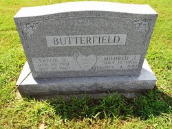
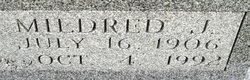
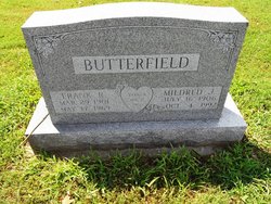
Mildred Jeanette Tope Butterfield
| Birth | : | 16 Jul 1906 Perry Township, Carroll County, Ohio, USA |
| Death | : | 4 Oct 1992 Carrollton, Carroll County, Ohio, USA |
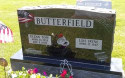
| Burial | : | High Cliff Cemetery, Sherwood, Calumet County, USA |
| Coordinate | : | 44.1707993, -88.2910995 |
| Description | : | Find A Grave contributor 46848597 provided the following: This was recorded in the Free Press Standard, Carrollton, Ohio, Thursday, September 1, 1927. A very beautiful wedding was solemnized Wednesday at noon at the home of Dr. and Mrs. U. I. Tope, of Lamartine, when their oldest daughter, Mildred Jeanette, was united in marriage to Franklin Roscoe Butterfield by Rev. A. O. Rhodes. The bride wore a gown of ivory satin and chantilly lace and carried a bouquet of bride's roses. The bridesmaids were Miss Wilma Tope, sister of the bride, and... Read More |
frequently asked questions (FAQ):
-
Where is Mildred Jeanette Tope Butterfield's memorial?
Mildred Jeanette Tope Butterfield's memorial is located at: High Cliff Cemetery, Sherwood, Calumet County, USA.
-
When did Mildred Jeanette Tope Butterfield death?
Mildred Jeanette Tope Butterfield death on 4 Oct 1992 in Carrollton, Carroll County, Ohio, USA
-
Where are the coordinates of the Mildred Jeanette Tope Butterfield's memorial?
Latitude: 44.1707993
Longitude: -88.2910995
Family Members:
Parent

Spouse
Siblings
Children

Flowers:


Nearby Cemetories:
1. High Cliff Cemetery
Sherwood, Calumet County, USA
Coordinate: 44.1707993, -88.2910995
2. Stacey Children Cemetery
Sherwood, Calumet County, USA
Coordinate: 44.1674900, -88.2936000
3. Forrest Run Pet Cemetery
Sherwood, Calumet County, USA
Coordinate: 44.1800400, -88.2953100
4. Sacred Heart Cemetery
Sherwood, Calumet County, USA
Coordinate: 44.1618996, -88.2639008
5. Mansfield Cemetery
Sherwood, Calumet County, USA
Coordinate: 44.1463300, -88.2814600
6. Saint Anthony Catholic Cemetery
Harrison, Calumet County, USA
Coordinate: 44.1342100, -88.2906400
7. Dorn Cemetery
Harrison, Calumet County, USA
Coordinate: 44.1211000, -88.3117000
8. Saint John Catholic Cemetery
Saint John, Calumet County, USA
Coordinate: 44.1674300, -88.2038000
9. Saint John Evangelical Lutheran Cemetery
Dundas, Calumet County, USA
Coordinate: 44.2206300, -88.2280690
10. Holy Angels Cemetery
Appleton, Outagamie County, USA
Coordinate: 44.2440000, -88.3318000
11. Saint Peters Cemetery
Hilbert, Calumet County, USA
Coordinate: 44.1333008, -88.1832962
12. Saint Marys Cemetery
Stockbridge, Calumet County, USA
Coordinate: 44.0842018, -88.3024979
13. Indian Cemetery
Stockbridge, Calumet County, USA
Coordinate: 44.0821991, -88.3013992
14. Holy Name Cemetery
Kimberly, Outagamie County, USA
Coordinate: 44.2586100, -88.3380600
15. St. Mary's Cemetery
Kaukauna, Outagamie County, USA
Coordinate: 44.2671100, -88.2884900
16. Saint Paul Cemetery
Combined Locks, Outagamie County, USA
Coordinate: 44.2676000, -88.2922000
17. Stockbridge Cemetery
Kaukauna, Outagamie County, USA
Coordinate: 44.2684746, -88.2818051
18. Union Cemetery
Kaukauna, Outagamie County, USA
Coordinate: 44.2689018, -88.2919006
19. Saint Marys Cemetery
Hilbert, Calumet County, USA
Coordinate: 44.1321983, -88.1647034
20. Portland Cemetery
Brant, Calumet County, USA
Coordinate: 44.0746994, -88.2241974
21. Saint John Cemetery
Little Chute, Outagamie County, USA
Coordinate: 44.2781200, -88.3144400
22. Saint Luke Lutheran Church Cemetery
Chilton, Calumet County, USA
Coordinate: 44.0874000, -88.1934100
23. First Congregational UCC Memorial Garden
Appleton, Outagamie County, USA
Coordinate: 44.2540700, -88.3932290
24. Saint John Nepomucene Cemetery
Little Chute, Outagamie County, USA
Coordinate: 44.2825012, -88.3103027