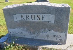
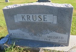
Mildred Mae Hammond Kruse
| Birth | : | 11 Jul 1918 Manchester, Delaware County, Iowa, USA |
| Death | : | 7 Jan 2010 Elkader, Clayton County, Iowa, USA |
| Burial | : | Waverley Cemetery, Waverley, South Taranaki District, New Zealand |
| Coordinate | : | -39.7675900, 174.6292700 |
| Description | : | Mildred May Kruse, 91, of Elkader, died Thursday, January 7, 2010, at Central Community Hospital in Elkader. She was born July 11, 1918 in Manchester to Nate and Dora (Foldman) Hammond. Mildred grew up around the Communia and Edgewood area. Mildred worked for Myles Coonfare in the Garber/Elkader area where she met her future husband, William Kruse. On June 23, 1936, Mildred and William were united in marriage. They farmed the family farm in Pine Hollow, rural Garber, until they retired from farming in the early 70's and moved to Clayton Center. Following William's death, she moved to Elkader. She was a... Read More |
frequently asked questions (FAQ):
-
Where is Mildred Mae Hammond Kruse's memorial?
Mildred Mae Hammond Kruse's memorial is located at: Waverley Cemetery, Waverley, South Taranaki District, New Zealand.
-
When did Mildred Mae Hammond Kruse death?
Mildred Mae Hammond Kruse death on 7 Jan 2010 in Elkader, Clayton County, Iowa, USA
-
Where are the coordinates of the Mildred Mae Hammond Kruse's memorial?
Latitude: -39.7675900
Longitude: 174.6292700
Family Members:
Flowers:
Nearby Cemetories:
1. Waverley Cemetery
Waverley, South Taranaki District, New Zealand
Coordinate: -39.7675900, 174.6292700
2. Patea General Cemetery
Patea, South Taranaki District, New Zealand
Coordinate: -39.7447980, 174.4685340
3. Pakaraka Māori Cemetery
Maxwell, Whanganui District, New Zealand
Coordinate: -39.8226300, 174.8460700
4. Maxwell Cemetery
Whanganui, Whanganui District, New Zealand
Coordinate: -39.8224020, 174.8530960
5. Manutahi Cemetery
Manutahi, South Taranaki District, New Zealand
Coordinate: -39.6594677, 174.3924181
6. Papanui Urupā
Kai Iwi, Whanganui District, New Zealand
Coordinate: -39.8435190, 174.9216230
7. Tiwhaiti Urupa (Taiporohenui Marae)
Hāwera, South Taranaki District, New Zealand
Coordinate: -39.5741843, 174.3216120
8. Brunswick Cemetery
Brunswick, Whanganui District, New Zealand
Coordinate: -39.8417750, 175.0216400
9. Hāwera Cemetery
Hāwera, South Taranaki District, New Zealand
Coordinate: -39.5897900, 174.2945500
10. Te Utinga Urupā
Normanby, South Taranaki District, New Zealand
Coordinate: -39.5330847, 174.2761055
11. Waihi Cemetery and Redoubt
Normanby, South Taranaki District, New Zealand
Coordinate: -39.5444930, 174.2566820
12. Heads Road Cemetery
Whanganui, Whanganui District, New Zealand
Coordinate: -39.9393300, 175.0473400
13. Putiki Urupā
Whanganui District, New Zealand
Coordinate: -39.9466140, 175.0499350
14. Aramoho Cemetery
Whanganui, Whanganui District, New Zealand
Coordinate: -39.8926494, 175.0922441
15. Ohawe Military Cemetery
Ohawe Beach, South Taranaki District, New Zealand
Coordinate: -39.5835138, 174.2003758
16. St. Mary's Anglican Church Cemetery
Upokongaro, Whanganui District, New Zealand
Coordinate: -39.8656100, 175.1132820
17. Weri Weri Urupa Aotearoa Marae
Okaiawa, South Taranaki District, New Zealand
Coordinate: -39.5190700, 174.2206700
18. Okaiawa Cemetery
Okaiawa, South Taranaki District, New Zealand
Coordinate: -39.5310220, 174.2042180
19. Jerusalem - Hiruhārama Urupā
Jerusalem, Whanganui District, New Zealand
Coordinate: -39.5521740, 175.0788340
20. Marshall Family Cemetery
Matahiwi, Whanganui District, New Zealand
Coordinate: -39.6757200, 175.1595964
21. Eltham Cemetery
Eltham, South Taranaki District, New Zealand
Coordinate: -39.4197140, 174.3251260
22. Matarawa Presbyterian Cemetery
Whanganui, Whanganui District, New Zealand
Coordinate: -39.9461300, 175.1433100
23. Manaia Cemetery
Manaia, South Taranaki District, New Zealand
Coordinate: -39.5575010, 174.1354470
24. Matarawa Cemetery
Fordell, Whanganui District, New Zealand
Coordinate: -39.9468100, 175.1452700


