

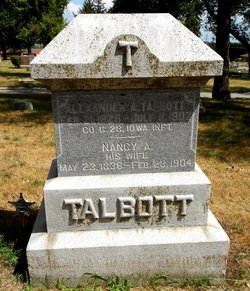
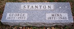
Mina Grant Talbott Stanton Mitchell
| Birth | : | 9 Dec 1872 Carroll County, Iowa, USA |
| Death | : | 25 Dec 1941 Redondo Beach, Los Angeles County, California, USA |
| Burial | : | Carroll City Cemetery, Carroll, Carroll County, USA |
| Coordinate | : | 42.0560963, -94.8599856 |
| Description | : | Jan 2, 1942 - Carroll Times - Funeral services for Mrs. Mina Stanton Mitchell, formerly of Carroll, who died at Rendondo Beach, Calif, Dec. 25, were held at 2 o'clock Wednesday afternoon at the Huffman Funeral Home, with the Rev. W.F. Clayburg, minister of the Methodist Church, officiating. The Eastern Star burial service was given by Miss Esther Juergens, worthy matron, and other officers of the local chapter. The musical part of the rites consisted of the hymns, "Abide With Me" and "Have Thine Own Way, Lord," sung by a quartet composed of Mrs. Larry Kozal, Mrs. Wilma Mohler, C.M.... Read More |
frequently asked questions (FAQ):
-
Where is Mina Grant Talbott Stanton Mitchell's memorial?
Mina Grant Talbott Stanton Mitchell's memorial is located at: Carroll City Cemetery, Carroll, Carroll County, USA.
-
When did Mina Grant Talbott Stanton Mitchell death?
Mina Grant Talbott Stanton Mitchell death on 25 Dec 1941 in Redondo Beach, Los Angeles County, California, USA
-
Where are the coordinates of the Mina Grant Talbott Stanton Mitchell's memorial?
Latitude: 42.0560963
Longitude: -94.8599856
Family Members:
Parent

Spouse
Siblings

Flowers:


Nearby Cemetories:
1. Carroll City Cemetery
Carroll, Carroll County, USA
Coordinate: 42.0560963, -94.8599856
2. Mount Olivet Cemetery
Carroll, Carroll County, USA
Coordinate: 42.0536340, -94.8595510
3. Holy Angels Cemetery
Carroll County, USA
Coordinate: 42.0014000, -94.9141998
4. Saint Francis Cemetery
Maple River, Carroll County, USA
Coordinate: 42.0969009, -94.9372025
5. Saint Marys Catholic Cemetery
Willey, Carroll County, USA
Coordinate: 41.9783363, -94.8212204
6. Holy Family Cemetery
Lidderdale, Carroll County, USA
Coordinate: 42.1178017, -94.7839966
7. West Lawn Cemetery
Glidden, Carroll County, USA
Coordinate: 42.0649986, -94.7406006
8. Immanuel Cemetery
Lidderdale, Carroll County, USA
Coordinate: 42.1389008, -94.8022003
9. Saint Augustine Cemetery
Halbur, Carroll County, USA
Coordinate: 42.0066986, -94.9744034
10. Our Lady Of Mount Carmel Cemetery
Mount Carmel, Carroll County, USA
Coordinate: 42.1547012, -94.9088974
11. Arcadia Cemetery
Arcadia Township, Carroll County, USA
Coordinate: 42.1000680, -95.0130550
12. East Liberty Cemetery
Lidderdale, Carroll County, USA
Coordinate: 42.1591988, -94.7636032
13. Saint Johns Catholic Cemetery
Arcadia, Carroll County, USA
Coordinate: 42.0855406, -95.0341577
14. Dickson Cemetery
Glidden Township, Carroll County, USA
Coordinate: 42.1074982, -94.6939011
15. McCurdy Cemetery
Carroll County, USA
Coordinate: 41.9403000, -94.7649994
16. Saint Bernards Cemetery
Breda, Carroll County, USA
Coordinate: 42.1786003, -94.9732971
17. Elba Cemetery
Templeton, Carroll County, USA
Coordinate: 41.9068985, -94.9131012
18. Sacred Heart Cemetery
Templeton, Carroll County, USA
Coordinate: 41.9138746, -94.9460994
19. North Coon Cemetery
Carroll County, USA
Coordinate: 42.1260986, -94.6716995
20. Dedham Cemetery
Dedham, Carroll County, USA
Coordinate: 41.8993988, -94.8225021
21. Saint Josephs Cemetery
Dedham, Carroll County, USA
Coordinate: 41.8993988, -94.8210983
22. Old Carrollton Cemetery
Carrollton, Carroll County, USA
Coordinate: 41.9233017, -94.7403030
23. Lanesboro Cemetery
Lanesboro, Carroll County, USA
Coordinate: 42.1810989, -94.7230988
24. Luckow Cemetery
Auburn, Sac County, USA
Coordinate: 42.2168999, -94.9266968