
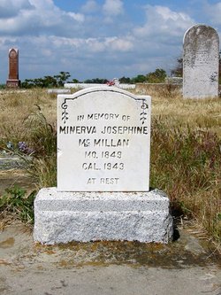
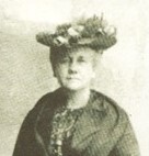

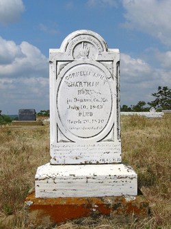
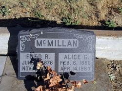
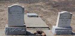
Minerva Josephine Browder McMillan
| Birth | : | 13 Mar 1849 Warsaw, Benton County, Missouri, USA |
| Death | : | 10 Aug 1943 Waterford, Stanislaus County, California, USA |
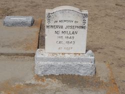
| Burial | : | Roberts Ferry Cemetery, Waterford, Stanislaus County, USA |
| Coordinate | : | 37.6408005, -120.6288986 |
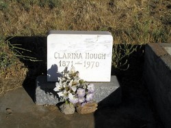
| Description | : | Notation on Stone: In Memory Of Mo1849 Ca 1943 At Rest∼Daughter of Minerva Turpin and James Browder. Minerva Josephine, her parents, and her siblings Green B., Clarissa (Clarina), Cordelia (Cornelia), Mary, Rosalie, and Victoria were part of the Tuolumne County Pioneers, emigrants who crossed into California over the Sonora Pass in 1853 via the Walker River Trail. (Additional info from Anne Shutleff Stevens, and confirmed at http://www.sonorapasspioneers.com/emigrants.html) |
frequently asked questions (FAQ):
-
Where is Minerva Josephine Browder McMillan's memorial?
Minerva Josephine Browder McMillan's memorial is located at: Roberts Ferry Cemetery, Waterford, Stanislaus County, USA.
-
When did Minerva Josephine Browder McMillan death?
Minerva Josephine Browder McMillan death on 10 Aug 1943 in Waterford, Stanislaus County, California, USA
-
Where are the coordinates of the Minerva Josephine Browder McMillan's memorial?
Latitude: 37.6408005
Longitude: -120.6288986
Family Members:
Parent
Spouse
Siblings
Children
Flowers:


Nearby Cemetories:
1. Roberts Ferry Cemetery
Waterford, Stanislaus County, USA
Coordinate: 37.6408005, -120.6288986
2. Maxwell Cemetery
Stanislaus County, USA
Coordinate: 37.7360000, -120.5923000
3. Martin Cemetery
Waterford, Stanislaus County, USA
Coordinate: 37.6684360, -120.7582160
4. French Bar Cemetery
La Grange, Stanislaus County, USA
Coordinate: 37.6617100, -120.4793000
5. La Grange Cemetery
La Grange, Stanislaus County, USA
Coordinate: 37.6619600, -120.4637000
6. Saint Louis Catholic Cemetery
Stanislaus County, USA
Coordinate: 37.6621830, -120.4613830
7. Hopeton Cemetery
Hopeton, Merced County, USA
Coordinate: 37.4883000, -120.5299200
8. Barfield Family Cemetery
Hopeton, Merced County, USA
Coordinate: 37.4675792, -120.6040085
9. William Knight Burial Site
Knights Ferry, Stanislaus County, USA
Coordinate: 37.8189200, -120.6729500
10. Knights Ferry Cemetery
Stanislaus County, USA
Coordinate: 37.8224907, -120.6830750
11. Denair Cemetery
Denair, Stanislaus County, USA
Coordinate: 37.5293999, -120.8199997
12. Snelling Pioneer Cemetery
Snelling, Merced County, USA
Coordinate: 37.5326030, -120.4318620
13. Snelling District Cemetery
Snelling, Merced County, USA
Coordinate: 37.5218887, -120.4353561
14. Oakdale Citizens Cemetery
Oakdale, Stanislaus County, USA
Coordinate: 37.7624600, -120.8388800
15. Lakewood Memorial Park
Hughson, Stanislaus County, USA
Coordinate: 37.6199760, -120.8975983
16. Saint Francis Episcopal Church Columbarium
Turlock, Stanislaus County, USA
Coordinate: 37.5014300, -120.8368400
17. Oaklawn Memorial Park
Oakdale, Stanislaus County, USA
Coordinate: 37.7711945, -120.8486862
18. Green Springs Burial Ground
Tuolumne County, USA
Coordinate: 37.8377780, -120.5073770
19. Ballard Cemetery
Tuolumne County, USA
Coordinate: 37.8150400, -120.4508200
20. Turlock Memorial Park
Turlock, Stanislaus County, USA
Coordinate: 37.4937592, -120.8659821
21. Langworth Cemetery
Oakdale, Stanislaus County, USA
Coordinate: 37.7580986, -120.8957977
22. Winton Cemetery
Winton, Merced County, USA
Coordinate: 37.3820267, -120.6260223
23. Ceres Memorial Park
Ceres, Stanislaus County, USA
Coordinate: 37.5958214, -120.9634399
24. Granite Spring Cemetery
Mariposa County, USA
Coordinate: 37.7210999, -120.3047028