
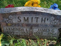
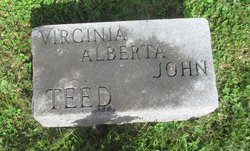
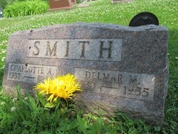
Minnie Arminda Lucifine Teed Smith
| Birth | : | 21 Nov 1899 |
| Death | : | 17 Feb 1988 |
| Burial | : | Gunnison Cemetery, Gunnison, Gunnison County, USA |
| Coordinate | : | 38.5463982, -106.8968964 |
frequently asked questions (FAQ):
-
Where is Minnie Arminda Lucifine Teed Smith's memorial?
Minnie Arminda Lucifine Teed Smith's memorial is located at: Gunnison Cemetery, Gunnison, Gunnison County, USA.
-
When did Minnie Arminda Lucifine Teed Smith death?
Minnie Arminda Lucifine Teed Smith death on 17 Feb 1988 in
-
Where are the coordinates of the Minnie Arminda Lucifine Teed Smith's memorial?
Latitude: 38.5463982
Longitude: -106.8968964
Family Members:
Parent
Spouse

Siblings

Children
Flowers:


Nearby Cemetories:
1. Gunnison Cemetery
Gunnison, Gunnison County, USA
Coordinate: 38.5463982, -106.8968964
2. Good Samaritan Episcopal Church Cemetery
Gunnison, Gunnison County, USA
Coordinate: 38.5452000, -106.9298000
3. Gunnsion's First Cemetery
Gunnison, Gunnison County, USA
Coordinate: 38.5302430, -106.9405590
4. Palisade Cemetery
Gunnison, Gunnison County, USA
Coordinate: 38.5516667, -106.9516667
5. Parlin Cemetery
Parlin, Gunnison County, USA
Coordinate: 38.4967290, -106.7274700
6. Iris Cemetery
Saguache County, USA
Coordinate: 38.4049988, -106.8217010
7. Jack's Cabin Cemetery
Gunnison County, USA
Coordinate: 38.7286000, -106.8504000
8. Ohio City Cemetery
Ohio, Gunnison County, USA
Coordinate: 38.5716000, -106.6198000
9. Doyleville Cemetery #3
Doyleville, Gunnison County, USA
Coordinate: 38.4403700, -106.6221000
10. Doyleville Cemetery #2
Doyleville, Gunnison County, USA
Coordinate: 38.4425000, -106.6189000
11. Doyleville Cemetery #1
Doyleville, Gunnison County, USA
Coordinate: 38.4519000, -106.6040000
12. Pitkin Cemetery
Pitkin, Gunnison County, USA
Coordinate: 38.6056000, -106.5285000
13. McGregor Cemetery
Powderhorn, Gunnison County, USA
Coordinate: 38.2818290, -107.1132820
14. Van Tassel Cemetery
Saguache County, USA
Coordinate: 38.2524610, -106.7486360
15. Powderhorn Family Cemetery
Powderhorn, Gunnison County, USA
Coordinate: 38.2453003, -107.0639038
16. Crested Butte Cemetery
Crested Butte, Gunnison County, USA
Coordinate: 38.8781000, -106.9755000
17. Carr Cemetery
Gunnison County, USA
Coordinate: 38.3213000, -107.2223000
18. Irwin Cemetery
Gunnison County, USA
Coordinate: 38.8507996, -107.0997009
19. Blue Mesa Cemetery
Sapinero, Gunnison County, USA
Coordinate: 38.4660920, -107.3252030
20. Tincup Cemetery
Tincup, Gunnison County, USA
Coordinate: 38.7494011, -106.4764023
21. White Pine Cemetery
Whitepine, Gunnison County, USA
Coordinate: 38.5315000, -106.4036000
22. Boothill Cemetery
Gunnison County, USA
Coordinate: 38.7477989, -106.4747009
23. Tomichi Cemetery
Gunnison County, USA
Coordinate: 38.5713997, -106.3696976
24. Nurse-Brownlee Cemetery
Powderhorn, Gunnison County, USA
Coordinate: 38.2355495, -107.2674895