
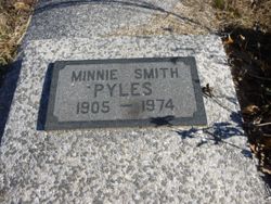
Minnie Brown Pyles
| Birth | : | 15 May 1905 Xenia, Bourbon County, Kansas, USA |
| Death | : | 2 Oct 1974 Garnett, Anderson County, Kansas, USA |
| Burial | : | Fairview Cemetery, Mildred, Allen County, USA |
| Coordinate | : | 38.0238020, -95.1401740 |
| Description | : | Minnie Smith Pyles, 69, of Kincaid, died Wednesday Oct. 2 at Anderson County Hospital in Garnett. Mrs. Pyles was born May 15, 1905 in Xenia. Survivors include her widower, Albert Pyles of Kincaid; two sons, William Glidden, Kincaid, and LeRoy Glidden, Hutchinson; three sisters, Mrs. Leona Hutton of Chanute, Mrs. Edna Lewis of Iola and Mrs. Lola Buckley, Wenatchee, Washington; 11 grandchildren and 11 great-grandchildren. Funeral services will be held at 2 p. m. Saturday at the Ralston-Hutton Chapel in Moran with the Rev. Paul Lewis officiating. Interment will be in the Fairview Cemetery, Mildred. Iola Register October 3, 1974 |
frequently asked questions (FAQ):
-
Where is Minnie Brown Pyles's memorial?
Minnie Brown Pyles's memorial is located at: Fairview Cemetery, Mildred, Allen County, USA.
-
When did Minnie Brown Pyles death?
Minnie Brown Pyles death on 2 Oct 1974 in Garnett, Anderson County, Kansas, USA
-
Where are the coordinates of the Minnie Brown Pyles's memorial?
Latitude: 38.0238020
Longitude: -95.1401740
Family Members:
Parent
Spouse

Siblings
Flowers:


Nearby Cemetories:
1. Fairview Cemetery
Mildred, Allen County, USA
Coordinate: 38.0238020, -95.1401740
2. Osage Valley Cemetery
Mildred, Allen County, USA
Coordinate: 38.0313988, -95.0969009
3. Stanley Cemetery
Bayard, Allen County, USA
Coordinate: 37.9944200, -95.0970400
4. Gillham Cemetery
Allen County, USA
Coordinate: 37.9795100, -95.1103500
5. Kincaid Cemetery
Kincaid, Anderson County, USA
Coordinate: 38.0917015, -95.1513977
6. Mount Zion Cemetery
Kincaid, Anderson County, USA
Coordinate: 38.1046982, -95.1864014
7. Boulware Cemetery
Mapleton, Bourbon County, USA
Coordinate: 38.0264600, -95.0245400
8. Old Blue Mound Cemetery
Blue Mound, Linn County, USA
Coordinate: 38.0636600, -95.0249000
9. Entswood Cemetery
Bronson, Bourbon County, USA
Coordinate: 37.9431480, -95.0603200
10. Lone Elm Cemetery
Lone Elm, Anderson County, USA
Coordinate: 38.0882988, -95.2422028
11. Anderson Cemetery #1
Xenia, Bourbon County, USA
Coordinate: 37.9907700, -95.0025000
12. Pleasant View Cemetery
Blue Mound, Linn County, USA
Coordinate: 38.0952988, -95.0175018
13. Sunny Slope Cemetery
Blue Mound, Linn County, USA
Coordinate: 38.0952988, -95.0149994
14. Stevenson Cemetery
Mapleton, Bourbon County, USA
Coordinate: 38.0210991, -94.9847031
15. Moran Cemetery
Moran, Allen County, USA
Coordinate: 37.9068985, -95.1892014
16. Ozark Cemetery #1
Anderson County, USA
Coordinate: 38.0424200, -95.2992300
17. Bronson Cemetery
Bronson, Bourbon County, USA
Coordinate: 37.8997100, -95.0792500
18. Pleasant Valley Cemetery
Allen County, USA
Coordinate: 38.0093994, -95.3328018
19. Oakwood Cemetery
Centerville, Linn County, USA
Coordinate: 38.1605988, -95.0391998
20. Golden Valley Cemetery
Allen County, USA
Coordinate: 37.8792572, -95.2235718
21. Pleasant View Cemetery
Bronson, Bourbon County, USA
Coordinate: 37.8996900, -95.0040500
22. Northway Cemetery
Mapleton, Bourbon County, USA
Coordinate: 37.9935989, -94.9321976
23. Sugar Valley Cemetery
Anderson County, USA
Coordinate: 38.1903300, -95.1130200
24. La Harpe Cemetery
La Harpe, Allen County, USA
Coordinate: 37.9067001, -95.3022003