
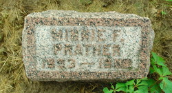

Minnie F. Keller Prather
| Birth | : | 9 Jul 1893 Vermilion County, Illinois, USA |
| Death | : | 21 Sep 1973 |
| Burial | : | White Hut Gaelic Cemetery, Clare, District Council of Clare and Gilbert Valleys, Australia |
| Coordinate | : | -33.8040010, 138.6283890 |
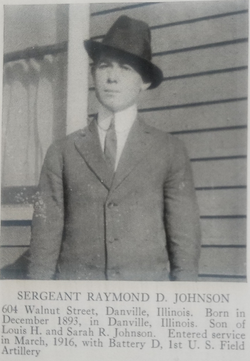
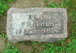
| Description | : | She was the daughter of Henry Keller and Margaret A. Howard. She married Oral Prather before 1929. She married Raymond D. Johnson in 1942. She has another stone in this same cemetery under Minnie Johnson. |
frequently asked questions (FAQ):
-
Where is Minnie F. Keller Prather's memorial?
Minnie F. Keller Prather's memorial is located at: White Hut Gaelic Cemetery, Clare, District Council of Clare and Gilbert Valleys, Australia.
-
When did Minnie F. Keller Prather death?
Minnie F. Keller Prather death on 21 Sep 1973 in
-
Where are the coordinates of the Minnie F. Keller Prather's memorial?
Latitude: -33.8040010
Longitude: 138.6283890
Family Members:
Spouse
Children
Flowers:


Nearby Cemetories:
1. White Hut Gaelic Cemetery
Clare, District Council of Clare and Gilbert Valleys, Australia
Coordinate: -33.8040010, 138.6283890
2. White Hut Cemetery
Stanley Flat, District Council of Clare and Gilbert Valleys, Australia
Coordinate: -33.7971650, 138.6234010
3. Stanley Flat Gaelic Cemetery
Clare, District Council of Clare and Gilbert Valleys, Australia
Coordinate: -33.7915580, 138.6066290
4. St. Barnabas Anglican Cemetery
Clare, District Council of Clare and Gilbert Valleys, Australia
Coordinate: -33.8301000, 138.6127000
5. Clare Presbyterian Cemetery
Clare, District Council of Clare and Gilbert Valleys, Australia
Coordinate: -33.8338460, 138.6156330
6. St. Michael's Catholic Cemetery
Clare, District Council of Clare and Gilbert Valleys, Australia
Coordinate: -33.8363060, 138.6096630
7. Clare General Cemetery
Clare, District Council of Clare and Gilbert Valleys, Australia
Coordinate: -33.8429900, 138.6016430
8. Clare Spring Farm Wesleyan Cemetery
Clare, District Council of Clare and Gilbert Valleys, Australia
Coordinate: -33.8630660, 138.6387190
9. St Michaels Anglican Church Cemetery
Bungaree, District Council of Clare and Gilbert Valleys, Australia
Coordinate: -33.7439580, 138.5616060
10. Sevenhill Cemetery
Sevenhill, District Council of Clare and Gilbert Valleys, Australia
Coordinate: -33.8861020, 138.6312260
11. Blyth Cemetery
Blyth, Wakefield Regional Council, Australia
Coordinate: -33.8261460, 138.4943480
12. St. Mark's Angelican Cemetery
Penwortham, District Council of Clare and Gilbert Valleys, Australia
Coordinate: -33.9214510, 138.6413830
13. Mintaro Catholic Cemetery
Mintaro, District Council of Clare and Gilbert Valleys, Australia
Coordinate: -33.9124530, 138.7194630
14. Farrell Flat Cemetery
Farrell Flats, Goyder Regional Council, Australia
Coordinate: -33.8249685, 138.7857266
15. Mintaro Cemetery
Mintaro, District Council of Clare and Gilbert Valleys, Australia
Coordinate: -33.9175520, 138.7164540
16. Kybunga Cemetery
Hoyleton, Wakefield Regional Council, Australia
Coordinate: -33.9202100, 138.5197360
17. Watervale Cemetery
Clare, District Council of Clare and Gilbert Valleys, Australia
Coordinate: -33.9678890, 138.6546991
18. Leasingham Upper Skilly Cemetery
Auburn, District Council of Clare and Gilbert Valleys, Australia
Coordinate: -33.9996690, 138.6179280
19. Angle Grove Cemetery
Brinkworth, Wakefield Regional Council, Australia
Coordinate: -33.6765530, 138.4376980
20. Springfield Cemetery
Williamstown, Barossa Council, Australia
Coordinate: -34.0000000, 138.5500000
21. St John’s Anglican Cemetery
Auburn, District Council of Clare and Gilbert Valleys, Australia
Coordinate: -34.0264310, 138.6835587
22. Black Springs Cemetery
Black Springs, District Council of Clare and Gilbert Valleys, Australia
Coordinate: -33.8884150, 138.8909940
23. Auburn Cemetery
Auburn, District Council of Clare and Gilbert Valleys, Australia
Coordinate: -34.0314560, 138.7036850
24. Manoora Catholic Cemetery
Manoora, District Council of Clare and Gilbert Valleys, Australia
Coordinate: -33.9911920, 138.8144040