
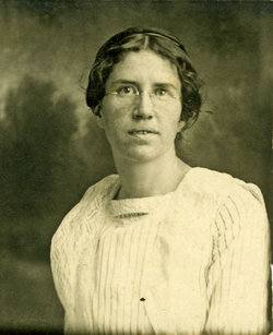
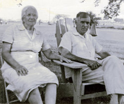
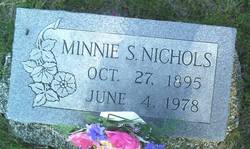
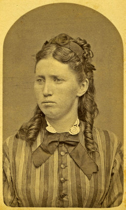
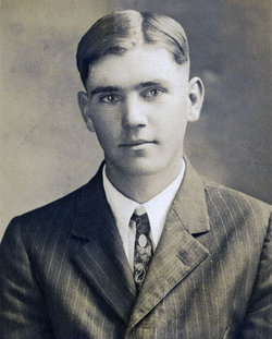
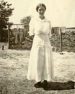
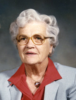
Minnie Sarah Hoskinson Nichols
| Birth | : | 27 Oct 1895 Vinland, Douglas County, Kansas, USA |
| Death | : | 4 Jun 1978 Baldwin City, Douglas County, Kansas, USA |
| Burial | : | Vinland Cemetery, Vinland, Douglas County, USA |
| Coordinate | : | 38.8485985, -95.1763992 |
| Plot | : | Lot 23 grave 01 |
| Description | : | Minnie Sarah Hoskinson was born on the family farm about three miles east of Vinland, Kansas. She was the seventh of eight children born to Joseph Dudley & Sarah Ellen (Anderson) Hoskinson. Minnie was raised near Vinland except for four years when she lived with her parents and two siblings at Las Vegas, New Mexico, where they had gone to try to improve her mother's health. The mother died when Minnie was 12 and the family returned to Vinland. After their mother's death, Minnie and her sister Clara did the housework for their father - cooking, cleaning, washing, ironing, canning... Read More |
frequently asked questions (FAQ):
-
Where is Minnie Sarah Hoskinson Nichols's memorial?
Minnie Sarah Hoskinson Nichols's memorial is located at: Vinland Cemetery, Vinland, Douglas County, USA.
-
When did Minnie Sarah Hoskinson Nichols death?
Minnie Sarah Hoskinson Nichols death on 4 Jun 1978 in Baldwin City, Douglas County, Kansas, USA
-
Where are the coordinates of the Minnie Sarah Hoskinson Nichols's memorial?
Latitude: 38.8485985
Longitude: -95.1763992
Family Members:
Parent
Spouse
Siblings
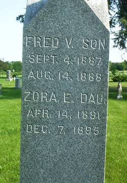

Children

Flowers:


Nearby Cemetories:
1. Stony Point Cemetery
Vinland, Douglas County, USA
Coordinate: 38.8249512, -95.2107391
2. Dow Cemetery
Vinland, Douglas County, USA
Coordinate: 38.8186620, -95.2143000
3. Brumbaugh Cemetery
Douglas County, USA
Coordinate: 38.8319200, -95.2330100
4. Breeze Family Cemetery
Pleasant Grove, Douglas County, USA
Coordinate: 38.8472800, -95.2480400
5. Blue Mound Cemetery
Lawrence, Douglas County, USA
Coordinate: 38.9046600, -95.1865400
6. Ulrich Cemetery
Pleasant Grove, Douglas County, USA
Coordinate: 38.8395740, -95.2531810
7. Clearfield Cemetery
Clearfield, Douglas County, USA
Coordinate: 38.8260002, -95.0930023
8. County Poor Farm Cemetery
Douglas County, USA
Coordinate: 38.9119400, -95.2214600
9. Richland Cemetery
Lawrence, Douglas County, USA
Coordinate: 38.8768997, -95.2630997
10. Kennedy Cemetery
Douglas County, USA
Coordinate: 38.9112900, -95.2269200
11. Marshall Cemetery
Douglas County, USA
Coordinate: 38.9040800, -95.2446700
12. Deay Cemetery
Eudora, Douglas County, USA
Coordinate: 38.8546486, -95.0749435
13. Oakwood Cemetery
Baldwin City, Douglas County, USA
Coordinate: 38.7694016, -95.1825027
14. Pleasant Hill Cemetery
Pleasant Grove, Douglas County, USA
Coordinate: 38.8535995, -95.2794037
15. Prairie City Cemetery
Baldwin City, Douglas County, USA
Coordinate: 38.7689018, -95.2050018
16. Mount Calvary Cemetery
Baldwin City, Douglas County, USA
Coordinate: 38.7687988, -95.2049713
17. Miller Family Cemetery
Baldwin City, Douglas County, USA
Coordinate: 38.7688751, -95.2146683
18. Baldwin City Cemetery
Baldwin City, Douglas County, USA
Coordinate: 38.7612953, -95.1862869
19. Cemetery Beni Israel
Eudora, Douglas County, USA
Coordinate: 38.9280128, -95.1122208
20. Dutton Cemetery
Douglas County, USA
Coordinate: 38.8989800, -95.2790600
21. Black Jack Cemetery
Douglas County, USA
Coordinate: 38.7660400, -95.1159400
22. Franklin Cemetery
Douglas County, USA
Coordinate: 38.9437523, -95.1869431
23. Haskell Cemetery
Lawrence, Douglas County, USA
Coordinate: 38.9353790, -95.2284241
24. Saint Johns Catholic Cemetery
Douglas County, USA
Coordinate: 38.9437900, -95.1919600