
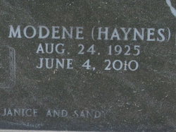
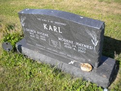
Modene J. Haynes Karl
| Birth | : | 24 Aug 1925 Tampa, Marion County, Kansas, USA |
| Death | : | 8 Jun 2010 Enterprise, Dickinson County, Kansas, USA |
| Burial | : | United Methodist Cemetery and Memorial Garden, New Providence, Union County, USA |
| Coordinate | : | 40.7033005, -74.4117966 |
| Plot | : | Karl |
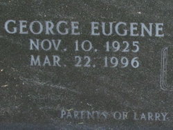
| Description | : | Modene J. Karl Tuesday, Jun 08, 2010 ENTERPRISE – Modene J. Karl, 84, of Enterprise, died Friday, June 4, 2010, at the Enterprise Estates Nursing Center in Enterprise. She was born Aug. 24, 1925, at Tampa, the daughter of Frank Lee and Wauneita (Medley) Haynes. She moved to Woodbine in her youth and graduated from Woodbine High School. On June 9, 1948, she was united in marriage with George Eugene Karl in the Ebenezer Baptist Church, south of Abilene. They made their home near Detroit, where they farmed. She had worked for the Citizens State Bank in Woodbine, the Detroit/Enterprise Elevator, as the... Read More |
frequently asked questions (FAQ):
-
Where is Modene J. Haynes Karl's memorial?
Modene J. Haynes Karl's memorial is located at: United Methodist Cemetery and Memorial Garden, New Providence, Union County, USA.
-
When did Modene J. Haynes Karl death?
Modene J. Haynes Karl death on 8 Jun 2010 in Enterprise, Dickinson County, Kansas, USA
-
Where are the coordinates of the Modene J. Haynes Karl's memorial?
Latitude: 40.7033005
Longitude: -74.4117966
Family Members:
Parent

Spouse
Siblings
Children

Flowers:


Nearby Cemetories:
1. United Methodist Cemetery and Memorial Garden
New Providence, Union County, USA
Coordinate: 40.7033005, -74.4117966
2. New Providence Presbyterian Churchyard
New Providence, Union County, USA
Coordinate: 40.7059441, -74.4068451
3. Saint Andrews Episcopal Church Memorial Garden
New Providence, Union County, USA
Coordinate: 40.6929500, -74.3996800
4. Faith Lutheran Church Memorial Garden
New Providence, Union County, USA
Coordinate: 40.6900840, -74.3973880
5. Saint Teresa Cemetery
Summit, Union County, USA
Coordinate: 40.7224998, -74.3869019
6. Willcocks and Badgley Families Cemetery
Berkeley Heights, Union County, USA
Coordinate: 40.6817550, -74.3873850
7. Presbyterian Church of Chatham Twp Memorial Garden
Chatham, Morris County, USA
Coordinate: 40.7321300, -74.4166800
8. Fair Mount Cemetery
Chatham, Morris County, USA
Coordinate: 40.7279663, -74.3892365
9. Saint Johns Lutheran Church Memorial Garden
Summit, Union County, USA
Coordinate: 40.7156410, -74.3680210
10. Monastery of Our Lady of the Rosary Cemetery
Summit, Union County, USA
Coordinate: 40.7176740, -74.3658290
11. Saint Vincent Cemetery
Madison, Morris County, USA
Coordinate: 40.7414017, -74.4103012
12. Meyersville Cemetery
Meyersville, Morris County, USA
Coordinate: 40.6917000, -74.4621964
13. Central Presbyterian Church Memorial Garden
Summit, Union County, USA
Coordinate: 40.7148490, -74.3595450
14. Saint Marys Cemetery
Watchung, Somerset County, USA
Coordinate: 40.6644440, -74.4325104
15. Calvary Episcopal Church Memorial Garden
Summit, Union County, USA
Coordinate: 40.7196420, -74.3602910
16. Meyersville Presbyterian Church Cemetery
Meyersville, Morris County, USA
Coordinate: 40.6894455, -74.4704132
17. Siebel Family Cemetery
Free Acres, Union County, USA
Coordinate: 40.6596100, -74.4455890
18. Union Village United Methodist Church Cemetery
Berkeley Heights, Union County, USA
Coordinate: 40.6658090, -74.4576820
19. Hillside Cemetery
Madison, Morris County, USA
Coordinate: 40.7550011, -74.4113998
20. Scotch Plains Baptist Church Cemetery
Scotch Plains, Union County, USA
Coordinate: 40.6517982, -74.3996964
21. Saint Bartholomew the Apostle Churchyard
Scotch Plains, Union County, USA
Coordinate: 40.6523640, -74.3912630
22. All Saints Episcopal Church Columbarium
Scotch Plains, Union County, USA
Coordinate: 40.6482890, -74.3944230
23. Tucker Family Burying Ground
Warren, Somerset County, USA
Coordinate: 40.6612930, -74.4641037
24. Fanwood Presbyterian Church Memorial Garden
Fanwood, Union County, USA
Coordinate: 40.6394080, -74.3822010