
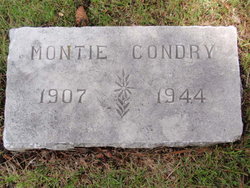
Montie Claud Condry
| Birth | : | 19 Apr 1907 Fort Smith, Sebastian County, Arkansas, USA |
| Death | : | 1944 Gordon, Sheridan County, Nebraska, USA |
| Burial | : | Gordon Cemetery, Gordon, Sheridan County, USA |
| Coordinate | : | 42.7858009, -102.2102966 |
| Description | : | Married Gertrude Lucille Grover on June 4, 1931, in Greeley (Weld County), Colorado. ********** Montie Claud Condry was born in Fort Smith, Arkansas, to “Monte” Montezuma Clyde Condry and Ethel Evans Condry. He grew up in Chelsea, Oklahoma, and Nowata County, Oklahoma, before moving to the Nebraska area in the late 1920s. The Obituary of his daughter, Viola, states she was two years old when her father died. She was born in August, 1944, which puts his death in late 1946 - early 1947. [Gravestone date may be in error]. Contributor: cards girl (48487892) |
frequently asked questions (FAQ):
-
Where is Montie Claud Condry's memorial?
Montie Claud Condry's memorial is located at: Gordon Cemetery, Gordon, Sheridan County, USA.
-
When did Montie Claud Condry death?
Montie Claud Condry death on 1944 in Gordon, Sheridan County, Nebraska, USA
-
Where are the coordinates of the Montie Claud Condry's memorial?
Latitude: 42.7858009
Longitude: -102.2102966
Family Members:
Parent
Spouse
Siblings
Children

Flowers:


Nearby Cemetories:
1. Gordon Cemetery
Gordon, Sheridan County, USA
Coordinate: 42.7858009, -102.2102966
2. Mount Hope Cemetery
Gordon, Sheridan County, USA
Coordinate: 42.7113991, -102.2241974
3. Dane Cemetery
Cherry County, USA
Coordinate: 42.7924300, -102.0824700
4. Bethel Cemetery
Sheridan County, USA
Coordinate: 42.9011002, -102.3208008
5. Lavaca Cemetery
Irwin, Cherry County, USA
Coordinate: 42.7332993, -102.0175018
6. Amity Cemetery
Sheridan County, USA
Coordinate: 42.8036003, -102.4389038
7. Fair View Cemetery
Rushville, Sheridan County, USA
Coordinate: 42.7155991, -102.4325027
8. Saint Aloysius Cemetery
Sheridan County, USA
Coordinate: 42.9015500, -102.4025500
9. Saint Marys Cemetery
Rushville, Sheridan County, USA
Coordinate: 42.7174988, -102.4436035
10. Feather on Head Cemetery
Oglala Lakota County, USA
Coordinate: 43.0311012, -102.1611023
11. Holly Cemetery
Rushville, Sheridan County, USA
Coordinate: 42.8575120, -102.5370990
12. Novotny Cemetery
Hay Springs, Sheridan County, USA
Coordinate: 42.7742004, -102.5963974
13. Davis Cemetery
Rushville, Sheridan County, USA
Coordinate: 42.5421000, -102.4118800
14. Wolf Creek Community Cemetery
Oglala Lakota County, USA
Coordinate: 43.0405750, -102.3966490
15. Spotted Bear Family Cemetery
Denby, Oglala Lakota County, USA
Coordinate: 43.0608200, -102.3376600
16. Preble Cemetery
Sheridan County, USA
Coordinate: 42.6504000, -102.5765000
17. Abold Family Cemetery
Rushville, Sheridan County, USA
Coordinate: 42.8863500, -102.6158000
18. Bomar Cemetery
Hay Springs, Sheridan County, USA
Coordinate: 42.8062000, -102.6459600
19. Native American Cemetery
Oglala, Oglala Lakota County, USA
Coordinate: 43.0886002, -102.3550034
20. White Clay Cemetery
Rushville, Sheridan County, USA
Coordinate: 42.9732820, -102.5667230
21. Knight Cemetery
Oglala Lakota County, USA
Coordinate: 43.1039009, -102.1200027
22. Holy Cross Cemetery
Pine Ridge, Oglala Lakota County, USA
Coordinate: 43.0194016, -102.5503006
23. Pine Ridge Presbyterian Cemetery
Pine Ridge, Oglala Lakota County, USA
Coordinate: 43.0235200, -102.5506200
24. Beguin Cemetery
Sheridan County, USA
Coordinate: 42.5107994, -102.4982986