
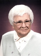

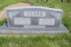
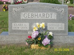
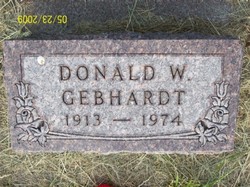
Mrs Marjorie Gebhardt Clark
| Birth | : | 13 Mar 1915 Green, Clay County, Kansas, USA |
| Death | : | 16 Jul 2012 Milwaukee, Milwaukee County, Wisconsin, USA |
| Burial | : | Fancy Creek Cemetery, Green, Clay County, USA |
| Coordinate | : | 39.4668999, -96.9969025 |
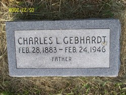
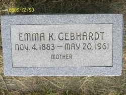
| Description | : | Marjorie Gebhardt Clark, age 97, of Milwaukee, Wisconsin, a former resident of Junction City, Kansas, passed away peacefully Monday, July 16, 2012, at the Terrace at St. Francis in Milwaukee, Wis. She was born March 13, 1915, at Green, Kan., the daughter of Charles and Emma (Alexander) Gebhardt. She graduated from the Green High School in 1933. After graduating from Emporia Teachers College in 1937 Marjorie taught elementary school in Burton, Kan. for 2 years. She married Roy W. Clark of Green on December 31,1941. They made their home in Junction City where she taught grade school for nearly... Read More |
frequently asked questions (FAQ):
-
Where is Mrs Marjorie Gebhardt Clark's memorial?
Mrs Marjorie Gebhardt Clark's memorial is located at: Fancy Creek Cemetery, Green, Clay County, USA.
-
When did Mrs Marjorie Gebhardt Clark death?
Mrs Marjorie Gebhardt Clark death on 16 Jul 2012 in Milwaukee, Milwaukee County, Wisconsin, USA
-
Where are the coordinates of the Mrs Marjorie Gebhardt Clark's memorial?
Latitude: 39.4668999
Longitude: -96.9969025
Family Members:
Parent
Spouse
Siblings
Flowers:


Nearby Cemetories:
1. Fancy Creek Cemetery
Green, Clay County, USA
Coordinate: 39.4668999, -96.9969025
2. Brethren in Christ Cemetery
Clay County, USA
Coordinate: 39.4810982, -97.0344009
3. Green Cemetery
Green, Clay County, USA
Coordinate: 39.4235992, -96.9882965
4. Goshen Central Cemetery
Clay Center, Clay County, USA
Coordinate: 39.5099983, -97.0160980
5. Joseph Sender Family Cemetery
Clay County, USA
Coordinate: 39.5090600, -97.0348800
6. Pleasant Hill Cemetery
Leonardville, Riley County, USA
Coordinate: 39.4371210, -96.9426730
7. Appleton Cemetery
Clay County, USA
Coordinate: 39.5250015, -96.9972000
8. May Day Cemetery
Center Township, Riley County, USA
Coordinate: 39.4958000, -96.9302979
9. Hayes Cemetery
Clay County, USA
Coordinate: 39.4516983, -97.0811005
10. Lasita Cemetery
Leonardville, Riley County, USA
Coordinate: 39.4092900, -96.9422900
11. Idylwilde Cemetery
Clay Center, Clay County, USA
Coordinate: 39.5097900, -97.0713000
12. Ebenezer Cemetery
Green, Clay County, USA
Coordinate: 39.3866997, -96.9974976
13. Swedish Pleasant Hill Cemetery
Clay Center, Clay County, USA
Coordinate: 39.4735985, -97.1268997
14. Clay County Poor Farm Cemetery
Clay Center, Clay County, USA
Coordinate: 39.3772700, -97.0727000
15. Saint Johns Lutheran Cemetery
Winkler, Riley County, USA
Coordinate: 39.4813995, -96.8494034
16. Garfield Center Mission Cemetery
Clay Center, Clay County, USA
Coordinate: 39.5243100, -97.1277500
17. Swedish Evangelical Lutheran Cemetery
Clay County, USA
Coordinate: 39.4911700, -97.1455100
18. Saint Peter and Saint Pauls Catholic Cemetery
Clay Center, Clay County, USA
Coordinate: 39.4005450, -97.1236680
19. Crooked Creek Cemetery
Randolph, Riley County, USA
Coordinate: 39.4369011, -96.8480988
20. Greenwood Cemetery
Clay Center, Clay County, USA
Coordinate: 39.4011002, -97.1275024
21. Zion Cemetery
Randolph, Riley County, USA
Coordinate: 39.5526139, -96.8853800
22. Teske Family Cemetery
Randolph, Riley County, USA
Coordinate: 39.4963830, -96.8294000
23. Leonardville Cemetery
Leonardville, Riley County, USA
Coordinate: 39.3792000, -96.8589020
24. Morganville City Cemetery
Morganville, Clay County, USA
Coordinate: 39.4733009, -97.1819000