
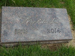
Mrs Mildred M. McCord Pfeifley
| Birth | : | 22 Feb 1921 Garden City, Finney County, Kansas, USA |
| Death | : | 23 Oct 2014 Leonardville, Riley County, Kansas, USA |
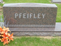
| Burial | : | Fancy Creek Cemetery, Green, Clay County, USA |
| Coordinate | : | 39.4668999, -96.9969025 |
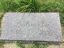
| Description | : | Mildred M. Pfeifley, age 93 of Clay Center, Kansas, died Thursday, October 23, 2014 at the Leonardville Nursing Home in Leonardville, Kansas. She was born on February 22, 1921 at Garden City, Kansas, the daughter of Arthur and Pearl Wooden McCord. She spent most of her youth in Wichita, Kansas. She married Edward Pfeifley on March 7, 1943, at Wichita, Kansas. They moved to the Pfeifley family farm at Green, Kansas and resided there until 1957. At that time they purchased, operated, and resided in the Holmes Funeral Home in Riley, Kansas. She had worked as a funeral director until her retirement... Read More |
frequently asked questions (FAQ):
-
Where is Mrs Mildred M. McCord Pfeifley's memorial?
Mrs Mildred M. McCord Pfeifley's memorial is located at: Fancy Creek Cemetery, Green, Clay County, USA.
-
When did Mrs Mildred M. McCord Pfeifley death?
Mrs Mildred M. McCord Pfeifley death on 23 Oct 2014 in Leonardville, Riley County, Kansas, USA
-
Where are the coordinates of the Mrs Mildred M. McCord Pfeifley's memorial?
Latitude: 39.4668999
Longitude: -96.9969025
Family Members:

Flowers:


Nearby Cemetories:
1. Fancy Creek Cemetery
Green, Clay County, USA
Coordinate: 39.4668999, -96.9969025
2. Brethren in Christ Cemetery
Clay County, USA
Coordinate: 39.4810982, -97.0344009
3. Green Cemetery
Green, Clay County, USA
Coordinate: 39.4235992, -96.9882965
4. Goshen Central Cemetery
Clay Center, Clay County, USA
Coordinate: 39.5099983, -97.0160980
5. Joseph Sender Family Cemetery
Clay County, USA
Coordinate: 39.5090600, -97.0348800
6. Pleasant Hill Cemetery
Leonardville, Riley County, USA
Coordinate: 39.4371210, -96.9426730
7. Appleton Cemetery
Clay County, USA
Coordinate: 39.5250015, -96.9972000
8. May Day Cemetery
Center Township, Riley County, USA
Coordinate: 39.4958000, -96.9302979
9. Hayes Cemetery
Clay County, USA
Coordinate: 39.4516983, -97.0811005
10. Lasita Cemetery
Leonardville, Riley County, USA
Coordinate: 39.4092900, -96.9422900
11. Idylwilde Cemetery
Clay Center, Clay County, USA
Coordinate: 39.5097900, -97.0713000
12. Ebenezer Cemetery
Green, Clay County, USA
Coordinate: 39.3866997, -96.9974976
13. Swedish Pleasant Hill Cemetery
Clay Center, Clay County, USA
Coordinate: 39.4735985, -97.1268997
14. Clay County Poor Farm Cemetery
Clay Center, Clay County, USA
Coordinate: 39.3772700, -97.0727000
15. Saint Johns Lutheran Cemetery
Winkler, Riley County, USA
Coordinate: 39.4813995, -96.8494034
16. Garfield Center Mission Cemetery
Clay Center, Clay County, USA
Coordinate: 39.5243100, -97.1277500
17. Swedish Evangelical Lutheran Cemetery
Clay County, USA
Coordinate: 39.4911700, -97.1455100
18. Saint Peter and Saint Pauls Catholic Cemetery
Clay Center, Clay County, USA
Coordinate: 39.4005450, -97.1236680
19. Crooked Creek Cemetery
Randolph, Riley County, USA
Coordinate: 39.4369011, -96.8480988
20. Greenwood Cemetery
Clay Center, Clay County, USA
Coordinate: 39.4011002, -97.1275024
21. Zion Cemetery
Randolph, Riley County, USA
Coordinate: 39.5526139, -96.8853800
22. Teske Family Cemetery
Randolph, Riley County, USA
Coordinate: 39.4963830, -96.8294000
23. Leonardville Cemetery
Leonardville, Riley County, USA
Coordinate: 39.3792000, -96.8589020
24. Morganville City Cemetery
Morganville, Clay County, USA
Coordinate: 39.4733009, -97.1819000