
| Birth | : | 14 Nov 1929 Clay County, Kansas, USA |
| Death | : | 17 Feb 2016 Overland Park, Johnson County, Kansas, USA |
| Burial | : | Greenwood Cemetery, Clay Center, Clay County, USA |
| Coordinate | : | 39.4011002, -97.1275024 |
| Plot | : | Addition 1, Blk 20-I, Lot 25 |
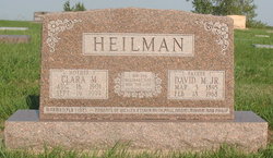
| Inscription | : | WIFE OF DONALD PARENTS OF LARRY & JEANNINE |
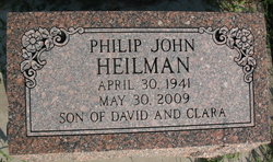
| Description | : | Ruth Ruby Chestnut, age 86 of Mission, Kansas and formerly of Clay Center, passed away Wednesday, February 17, 2016 at Garden Terrace of Overland Park. She was born on November 14, 1929 on her family farm outside of Green, the daughter of David M. and Clara (Reiker) Heilman. On June 4, 1955, she was married to Donald Dean Chestnut at the Wesleyan Methodist Church in Clay Center. He preceded her in death on June 29, 2001. Ruth was a homemaker and had worked at Parkview Plaza/Apollo Towers in Clay Center. She moved in when Parkview Plaza was brand new in 1981 and lived... Read More |
frequently asked questions (FAQ):
-
Where is Mrs Ruth Ruby Heilman Chestnut's memorial?
Mrs Ruth Ruby Heilman Chestnut's memorial is located at: Greenwood Cemetery, Clay Center, Clay County, USA.
-
When did Mrs Ruth Ruby Heilman Chestnut death?
Mrs Ruth Ruby Heilman Chestnut death on 17 Feb 2016 in Overland Park, Johnson County, Kansas, USA
-
Where are the coordinates of the Mrs Ruth Ruby Heilman Chestnut's memorial?
Latitude: 39.4011002
Longitude: -97.1275024
Family Members:
Parent

Spouse

Siblings
Flowers:


Nearby Cemetories:
1. Greenwood Cemetery
Clay Center, Clay County, USA
Coordinate: 39.4011002, -97.1275024
2. Saint Peter and Saint Pauls Catholic Cemetery
Clay Center, Clay County, USA
Coordinate: 39.4005450, -97.1236680
3. Clay County Poor Farm Cemetery
Clay Center, Clay County, USA
Coordinate: 39.3772700, -97.0727000
4. Wilson Cemetery
Clay County, USA
Coordinate: 39.3800011, -97.1896973
5. Hayes Cemetery
Clay County, USA
Coordinate: 39.4516983, -97.0811005
6. Republican City Cemetery
Clay Center, Clay County, USA
Coordinate: 39.3431015, -97.1628036
7. Swedish Pleasant Hill Cemetery
Clay Center, Clay County, USA
Coordinate: 39.4735985, -97.1268997
8. Morganville City Cemetery
Morganville, Clay County, USA
Coordinate: 39.4733009, -97.1819000
9. Broughton Cemetery
Clay Center, Clay County, USA
Coordinate: 39.3306007, -97.0535965
10. Swedish Evangelical Lutheran Cemetery
Clay County, USA
Coordinate: 39.4911700, -97.1455100
11. Ebenezer Cemetery
Green, Clay County, USA
Coordinate: 39.3866997, -96.9974976
12. Brethren in Christ Cemetery
Clay County, USA
Coordinate: 39.4810982, -97.0344009
13. Green Cemetery
Green, Clay County, USA
Coordinate: 39.4235992, -96.9882965
14. Norwegian Lutheran Cemetery
Clay Center, Clay County, USA
Coordinate: 39.5027900, -97.1828200
15. Zion Lutheran Cemetery
Clay County, USA
Coordinate: 39.2928009, -97.1557999
16. Idylwilde Cemetery
Clay Center, Clay County, USA
Coordinate: 39.5097900, -97.0713000
17. Idana Cemetery
Idana, Clay County, USA
Coordinate: 39.3574500, -97.2693300
18. Milo Chapman Gravesite
Broughton, Clay County, USA
Coordinate: 39.2888500, -97.0724400
19. Fancy Creek Cemetery
Green, Clay County, USA
Coordinate: 39.4668999, -96.9969025
20. Garfield Center Mission Cemetery
Clay Center, Clay County, USA
Coordinate: 39.5243100, -97.1277500
21. Gilbert Cemetery
Clay County, USA
Coordinate: 39.2853012, -97.0625000
22. Bloom Cemetery
Morganville, Clay County, USA
Coordinate: 39.4519005, -97.2778015
23. Joseph Sender Family Cemetery
Clay County, USA
Coordinate: 39.5090600, -97.0348800
24. Lincoln Cemetery
Clay Center, Clay County, USA
Coordinate: 39.4230995, -97.2930984