


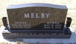
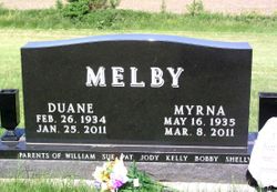
Myrna Cline Melby
| Birth | : | 16 May 1935 Dunlap, Harrison County, Iowa, USA |
| Death | : | 8 Mar 2011 Fort Dodge, Webster County, Iowa, USA |
| Burial | : | St John the Baptist Churchyard, Saxmundham, Suffolk Coastal District, England |
| Coordinate | : | 52.2129440, 1.4953350 |
| Plot | : | Sect D D 44 |
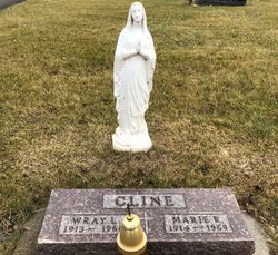
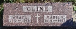
| Description | : | SOLDIER, Iowa -- Myrna Melby, 75, of Soldier died Tuesday, March 8, 2011, at Paula J. Baber Hospice Home in Fort Dodge, Iowa. yrna Melby, 75, Soldier, Iowa passed away Tuesday, March 8, 2011 at Paula J. Baber Hospice Home at Fort Dodge, Iowa. Funeral services will be 10:30 a.m. Saturday, March 12, 2011 at Soldier Lutheran Church with Pastor Jay Denne and Pastor Jason Cooper officiating. Burial will be in Soldier Lutheran Cemetery. a, Iowa. Myrna was born May 16, 1935 at Dunlap, Iowa, the daughter of Wray and Marie (Rogers) Cline. She was raised in Dunlap and graduated from St. Joseph... Read More |
frequently asked questions (FAQ):
-
Where is Myrna Cline Melby's memorial?
Myrna Cline Melby's memorial is located at: St John the Baptist Churchyard, Saxmundham, Suffolk Coastal District, England.
-
When did Myrna Cline Melby death?
Myrna Cline Melby death on 8 Mar 2011 in Fort Dodge, Webster County, Iowa, USA
-
Where are the coordinates of the Myrna Cline Melby's memorial?
Latitude: 52.2129440
Longitude: 1.4953350
Family Members:
Parent
Spouse
Siblings

Flowers:


Nearby Cemetories:
1. St John the Baptist Churchyard
Saxmundham, Suffolk Coastal District, England
Coordinate: 52.2129440, 1.4953350
2. Saxmundham Cemetery
Saxmundham, Suffolk Coastal District, England
Coordinate: 52.2129370, 1.4875290
3. United Reformed Church Churchyard
Saxmundham, Suffolk Coastal District, England
Coordinate: 52.2151680, 1.4879910
4. St Peter
Carlton, Suffolk Coastal District, England
Coordinate: 52.2227100, 1.4864500
5. St. Mary Magdalene Church Burial Ground
Sternfield, Suffolk Coastal District, England
Coordinate: 52.2005250, 1.4971480
6. St Mary Churchyard
Benhall, Suffolk Coastal District, England
Coordinate: 52.2039100, 1.4700610
7. St. Peter and St. Mary Churchyard
Kelsale, Suffolk Coastal District, England
Coordinate: 52.2324700, 1.4953900
8. St Mary Parish Churchyard
Friston, Suffolk Coastal District, England
Coordinate: 52.1898500, 1.5288200
9. St John The Baptist Churchyard
Snape, Suffolk Coastal District, England
Coordinate: 52.1804590, 1.5019170
10. St. Lawrence Churchyard
Knodishall, Suffolk Coastal District, England
Coordinate: 52.2024000, 1.5488000
11. St Mary's Church Burial Ground
Farnham, Suffolk Coastal District, England
Coordinate: 52.1872580, 1.4549173
12. Stratford St Andrew Church Burial Ground
Stratford St Andrew, Suffolk Coastal District, England
Coordinate: 52.1892250, 1.4483270
13. St. Michael's Churchyard
Rendham, Suffolk Coastal District, England
Coordinate: 52.2284620, 1.4394010
14. St. Mary the Virgin Churchyard
Sweffling, Suffolk Coastal District, England
Coordinate: 52.2228140, 1.4354510
15. Leiston Cemetery
Leiston, Suffolk Coastal District, England
Coordinate: 52.2105940, 1.5626350
16. St. Margaret's Parish Churchyard
Leiston, Suffolk Coastal District, England
Coordinate: 52.2066800, 1.5679300
17. Church of All Saints
Great Glemham, Suffolk Coastal District, England
Coordinate: 52.2032710, 1.4230110
18. Quaker cemetery
Leiston, Suffolk Coastal District, England
Coordinate: 52.2073800, 1.5742950
19. St. Peter's Churchyard
Theberton, Suffolk Coastal District, England
Coordinate: 52.2374790, 1.5682140
20. St. Peter's Churchyard Extension
Theberton, Suffolk Coastal District, England
Coordinate: 52.2374910, 1.5693750
21. St George's Churchyard
Dittisham, South Hams District, England
Coordinate: 52.1993239, 1.5785005
22. St Andrew at Little Glemham
Little Glemham, Suffolk Coastal District, England
Coordinate: 52.1768530, 1.4305400
23. Holy Trinity Churchyard
Middleton, Suffolk Coastal District, England
Coordinate: 52.2542140, 1.5589130
24. St. Botolph's Churchyard
Iken, Suffolk Coastal District, England
Coordinate: 52.1550820, 1.5250830