
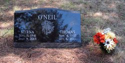

Myrna Lee Smith O'Neil
| Birth | : | 11 Sep 1941 Ekalaka, Carter County, Montana, USA |
| Death | : | 9 Jul 2013 Lincoln County, Montana, USA |
| Burial | : | Milnor Lake Cemetery, Troy, Lincoln County, USA |
| Coordinate | : | 48.4181150, -115.8259500 |
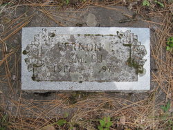
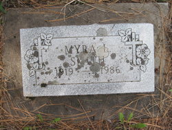
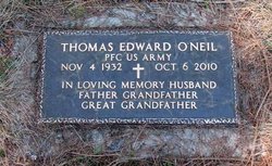
| Description | : | Myrna Lee (Smith) O'Neil Myrna was born Sept. 11, 1941, to Vernon and Myra Smith in Ekalaka. She lived all over Montana with her parents. In the late '50s they settled in Troy. She attended and graduated beauty school and also worked on the Libby Dam project as a flagger. While working at the dam she met Tom O'Neil. They were married May 17, 1968, and together raised four children and were a help to many others during the years. Myrna enjoyed hunting, fishing, making candy, crocheting, spoiling her grandchildren, playing with her dog, Skippy, and singing to the Lord.... Read More |
frequently asked questions (FAQ):
-
Where is Myrna Lee Smith O'Neil's memorial?
Myrna Lee Smith O'Neil's memorial is located at: Milnor Lake Cemetery, Troy, Lincoln County, USA.
-
When did Myrna Lee Smith O'Neil death?
Myrna Lee Smith O'Neil death on 9 Jul 2013 in Lincoln County, Montana, USA
-
Where are the coordinates of the Myrna Lee Smith O'Neil's memorial?
Latitude: 48.4181150
Longitude: -115.8259500
Family Members:
Parent
Spouse
Flowers:


Nearby Cemetories:
1. Milnor Lake Cemetery
Troy, Lincoln County, USA
Coordinate: 48.4181150, -115.8259500
2. Larchwood Cemetery
Lincoln County, USA
Coordinate: 48.4178009, -115.8257980
3. Troy Cemetery
Troy, Lincoln County, USA
Coordinate: 48.4752330, -115.8992710
4. Winn Family Cemetery
Lincoln County, USA
Coordinate: 48.5488590, -115.9644710
5. Bull Lake Guest Ranch Cemetery
Troy, Lincoln County, USA
Coordinate: 48.2424940, -115.8275090
6. Libby Cemetery
Libby, Lincoln County, USA
Coordinate: 48.3893540, -115.5646380
7. Leonia Cemetery
Leonia, Boundary County, USA
Coordinate: 48.6161720, -116.0497860
8. Boulder Creek Cemetery
Boundary County, USA
Coordinate: 48.6194000, -116.0571976
9. Sylvanite Cemetery
Lincoln County, USA
Coordinate: 48.7210000, -115.8745000
10. Clark Fork Cemetery
Clark Fork, Bonner County, USA
Coordinate: 48.1610000, -116.1690000
11. Cloudledge Cemetery
East Hope, Bonner County, USA
Coordinate: 48.2345670, -116.2772340
12. Hope Cemetery
East Hope, Bonner County, USA
Coordinate: 48.2449989, -116.2966995
13. Owen Family Cemetery
East Hope, Bonner County, USA
Coordinate: 48.2160100, -116.2790200
14. Old Hope Cemetery
Hope, Bonner County, USA
Coordinate: 48.2530500, -116.3157300
15. Heron Cemetery
Heron, Sanders County, USA
Coordinate: 48.0613000, -115.9621000
16. Cabinet Cemetery
Bonner County, USA
Coordinate: 48.0826000, -116.0681000
17. Parker Family Cemetery
Boundary County, USA
Coordinate: 48.6665200, -116.2619200
18. Paradise Valley Cemetery
Bonners Ferry, Boundary County, USA
Coordinate: 48.6453018, -116.3080978
19. Gold Creek Cemetery
Bonner County, USA
Coordinate: 48.4000015, -116.4160995
20. Holy Myrrhbearers Orthodox Church Parish Cemetery
Bonners Ferry, Boundary County, USA
Coordinate: 48.6190260, -116.3598830
21. Grandview Cemetery
Bonners Ferry, Boundary County, USA
Coordinate: 48.6851300, -116.2932700
22. Pack River Cemetery
Bonner County, USA
Coordinate: 48.3675620, -116.4404120
23. McArthur Cemetery
Boundary County, USA
Coordinate: 48.5246000, -116.4350000
24. Noxon Cemetery
Noxon, Sanders County, USA
Coordinate: 47.9908295, -115.7822189