
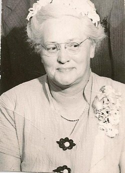
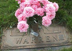
Myrtle Irene Brown Warren
| Birth | : | 4 Oct 1900 Beadle County, South Dakota, USA |
| Death | : | 6 Feb 1993 Miller, Hand County, South Dakota, USA |
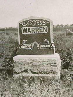
| Burial | : | Wessington Cemetery, Hand County, USA |
| Coordinate | : | 44.4569016, -98.7102966 |
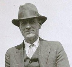
| Description | : | Myrtle Warren, 92, passed away February 6, 1993 at Prairie Center in Miller, SD. Arrangements were handled by Reck Funeral Home. Burial was in the Wessington Cemetery. Myrtle Irene Brown was born in Beadle County to Wellington and Elma (Watkins) Brown on October 6, 1900. Myrtle married Fred Warren on January 27, 1919 in Huron, SD. Fred and Myrtle lived on a farm in Gilbert Township until 1934 when they moved to Vayland. In 1939 they moved to Miller, SD. In their early years together, Fred and Myrtle enjoyed square dancing at barn dances and later at the activity center of St.... Read More |
frequently asked questions (FAQ):
-
Where is Myrtle Irene Brown Warren's memorial?
Myrtle Irene Brown Warren's memorial is located at: Wessington Cemetery, Hand County, USA.
-
When did Myrtle Irene Brown Warren death?
Myrtle Irene Brown Warren death on 6 Feb 1993 in Miller, Hand County, South Dakota, USA
-
Where are the coordinates of the Myrtle Irene Brown Warren's memorial?
Latitude: 44.4569016
Longitude: -98.7102966
Family Members:
Parent
Spouse
Siblings
Children

Flowers:


Nearby Cemetories:
1. Wessington Cemetery
Hand County, USA
Coordinate: 44.4569016, -98.7102966
2. Saint Josephs Catholic Cemetery
Hand County, USA
Coordinate: 44.4574400, -98.7100400
3. McCord Cemetery
Wessington, Beadle County, USA
Coordinate: 44.3998500, -98.6673100
4. Sand Creek Cemetery
Beadle County, USA
Coordinate: 44.3055800, -98.6791200
5. Beulah Cemetery
Vayland, Hand County, USA
Coordinate: 44.6060982, -98.8060989
6. Saint Johns Lutheran Cemetery
Wolsey, Beadle County, USA
Coordinate: 44.3927994, -98.4985962
7. Rosehill Cemetery
Hand County, USA
Coordinate: 44.2980995, -98.7731018
8. Saint Lawrence Cemetery
Saint Lawrence, Hand County, USA
Coordinate: 44.5292015, -98.9321976
9. Wolsey Cemetery
Wolsey, Beadle County, USA
Coordinate: 44.4000015, -98.4546967
10. Saint Ann's Cemetery
Miller, Hand County, USA
Coordinate: 44.5222015, -98.9732971
11. G A R Cemetery
Miller, Hand County, USA
Coordinate: 44.5078011, -98.9858017
12. Bonilla Cemetery
Bonilla, Beadle County, USA
Coordinate: 44.5830994, -98.4835968
13. Molvig Cemetery
Virgil, Beadle County, USA
Coordinate: 44.2552900, -98.6145900
14. Hillcrest Cemetery
Miller, Hand County, USA
Coordinate: 44.5207000, -99.0006100
15. Garfield Cemetery
Spink County, USA
Coordinate: 44.6622009, -98.5535965
16. Buffalo Cemetery
Spink County, USA
Coordinate: 44.6918983, -98.6853027
17. Sunbeam Cemetery
Hand County, USA
Coordinate: 44.6777992, -98.8407974
18. Burdette Cemetery
Burdette, Hand County, USA
Coordinate: 44.7002983, -98.7869034
19. Earlville Cemetery
Beadle County, USA
Coordinate: 44.2118988, -98.6091995
20. Altoona Cemetery
Hitchcock, Beadle County, USA
Coordinate: 44.6108017, -98.4113998
21. New Zion Cemetery
Hand County, USA
Coordinate: 44.2043991, -98.8206024
22. Saint Johns Cemetery
Tulare, Spink County, USA
Coordinate: 44.7202988, -98.6600037
23. Virgil Cemetery
Virgil, Beadle County, USA
Coordinate: 44.2904800, -98.4176700
24. Broadland Catholic Cemetery
Broadland, Beadle County, USA
Coordinate: 44.5005000, -98.3380800