
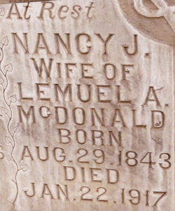
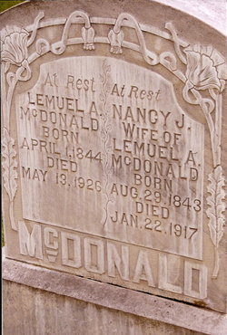
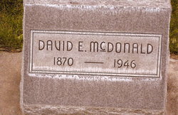
Nancy Jane Ray McDonald
| Birth | : | 29 Aug 1843 Morgan County, Indiana, USA |
| Death | : | 22 Jan 1917 North Platte, Lincoln County, Nebraska, USA |
| Burial | : | DeWitt City Cemetery, DeWitt, Clinton County, USA |
| Coordinate | : | 42.8476219, -84.5676498 |
| Description | : | Daughter of John C. Ray, b. ~1816 NC Buried Jan 24, 1917 Lot 780 |
frequently asked questions (FAQ):
-
Where is Nancy Jane Ray McDonald's memorial?
Nancy Jane Ray McDonald's memorial is located at: DeWitt City Cemetery, DeWitt, Clinton County, USA.
-
When did Nancy Jane Ray McDonald death?
Nancy Jane Ray McDonald death on 22 Jan 1917 in North Platte, Lincoln County, Nebraska, USA
-
Where are the coordinates of the Nancy Jane Ray McDonald's memorial?
Latitude: 42.8476219
Longitude: -84.5676498
Family Members:
Parent
Spouse
Siblings

Children
Flowers:


Nearby Cemetories:
1. DeWitt City Cemetery
DeWitt, Clinton County, USA
Coordinate: 42.8476219, -84.5676498
2. Saint Michael the Archangel Cemetery
DeWitt, Clinton County, USA
Coordinate: 42.8415490, -84.5880960
3. Wilsey Cemetery
DeWitt, Clinton County, USA
Coordinate: 42.8633003, -84.5128021
4. Alward Cemetery
Olive Township, Clinton County, USA
Coordinate: 42.8925018, -84.5717010
5. Hurd Cemetery
DeWitt, Clinton County, USA
Coordinate: 42.7999992, -84.5733032
6. Gunnisonville Cemetery
Gunnisonville, Clinton County, USA
Coordinate: 42.8124962, -84.5219879
7. South Riley Township Cemetery
South Riley, Clinton County, USA
Coordinate: 42.8633003, -84.6414032
8. Chapel Hill Memorial Gardens
DeWitt, Clinton County, USA
Coordinate: 42.7738810, -84.6113460
9. Merrihew Cemetery
Olive Township, Clinton County, USA
Coordinate: 42.9294014, -84.5663986
10. Pleasant Hill Cemetery
Bath, Clinton County, USA
Coordinate: 42.8074989, -84.4492035
11. Wacousta Cemetery
Wacousta, Clinton County, USA
Coordinate: 42.8206980, -84.6963820
12. Saint Joseph Catholic Cemetery
Lansing, Ingham County, USA
Coordinate: 42.7505989, -84.5883026
13. Hillside Cemetery
Delta Mills, Eaton County, USA
Coordinate: 42.7647600, -84.6421600
14. Saint David's Memorial Garden
Delta Township, Eaton County, USA
Coordinate: 42.7514420, -84.6231690
15. Georgia Cemetery
Saint Johns, Clinton County, USA
Coordinate: 42.9439011, -84.6367035
16. South Bingham Cemetery
Saint Johns, Clinton County, USA
Coordinate: 42.9580994, -84.5516968
17. Reed Cemetery
Victor Township, Clinton County, USA
Coordinate: 42.8918991, -84.4281006
18. First Presbyterian Church Memorial Garden
Lansing, Ingham County, USA
Coordinate: 42.7349700, -84.5592150
19. Saint Pauls Episcopal Church Memorial Garden
Lansing, Ingham County, USA
Coordinate: 42.7348300, -84.5551480
20. Stilson Cemetery
Saint Johns, Clinton County, USA
Coordinate: 42.9261017, -84.4436035
21. Unitarian Universalist Church Memorial Gardens
East Lansing, Ingham County, USA
Coordinate: 42.7427540, -84.4825510
22. All Saints Episcopal Church Memorial Garden
East Lansing, Ingham County, USA
Coordinate: 42.7423020, -84.4825220
23. Saint Peter Lutheran Cemetery
Saint Johns, Clinton County, USA
Coordinate: 42.9230995, -84.7014008
24. Bray Cemetery
Saint Johns, Clinton County, USA
Coordinate: 42.9594002, -84.6414032