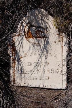
| Birth | : | 30 Nov 1832 Champaign County, Ohio, USA |
| Death | : | 6 Jan 1885 Glenrock, Nemaha County, Nebraska, USA |
| Burial | : | Karn Cemetery, Glenrock, Nemaha County, USA |
| Coordinate | : | 40.4789000, -95.7917000 |
| Inscription | : | Nancy Jane Rolston married William Edwards in McLean County, Illinois on November 18, 1854. |
| Description | : | Wife of William Age 52y 1m 7d |
frequently asked questions (FAQ):
-
Where is Nancy Jane Rolston Edwards's memorial?
Nancy Jane Rolston Edwards's memorial is located at: Karn Cemetery, Glenrock, Nemaha County, USA.
-
When did Nancy Jane Rolston Edwards death?
Nancy Jane Rolston Edwards death on 6 Jan 1885 in Glenrock, Nemaha County, Nebraska, USA
-
Where are the coordinates of the Nancy Jane Rolston Edwards's memorial?
Latitude: 40.4789000
Longitude: -95.7917000
Family Members:
Parent
Spouse
Siblings
Children
Flowers:
Nearby Cemetories:
1. Karn Cemetery
Glenrock, Nemaha County, USA
Coordinate: 40.4789000, -95.7917000
2. Highland Methodist Cemetery
Nemaha County, USA
Coordinate: 40.4581850, -95.8097140
3. Highland Baptist Cemetery
Auburn, Nemaha County, USA
Coordinate: 40.4578018, -95.8191986
4. Mount Vernon Cemetery
Peru, Nemaha County, USA
Coordinate: 40.4768982, -95.7208023
5. Saint Bernards Church Cemetery
Julian, Nemaha County, USA
Coordinate: 40.5078000, -95.8592000
6. London Cemetery
Peru, Nemaha County, USA
Coordinate: 40.4225006, -95.7621994
7. Glenrock Cemetery
Glenrock, Nemaha County, USA
Coordinate: 40.4644012, -95.8764038
8. Honey Creek Cemetery
Nemaha Township, Nemaha County, USA
Coordinate: 40.4430199, -95.6980820
9. Camp Creek Cemetery
Otoe County, USA
Coordinate: 40.5681000, -95.8019028
10. Sheridan Cemetery
Auburn, Nemaha County, USA
Coordinate: 40.3936005, -95.8591995
11. Linden Cemetery
Nemaha County, USA
Coordinate: 40.4216995, -95.9032974
12. Sheridan West Memorial Cemetery
Auburn, Nemaha County, USA
Coordinate: 40.3920580, -95.8701320
13. Sonora Cemetery
Watson, Atchison County, USA
Coordinate: 40.4730988, -95.6521988
14. Bloomingdale Cemetery
Otoe County, USA
Coordinate: 40.5685997, -95.8783035
15. Saint Paul Lutheran Cemetery
Auburn, Nemaha County, USA
Coordinate: 40.3752000, -95.8573000
16. Walnut Grove Cemetery
Brownville, Nemaha County, USA
Coordinate: 40.4023056, -95.6642990
17. Lafayette Cemetery
Brock, Nemaha County, USA
Coordinate: 40.5127983, -95.9543991
18. Coryell Park Mausoleum
Johnson, Nemaha County, USA
Coordinate: 40.4371150, -95.9548690
19. Williams Cemetery
Nebraska City, Otoe County, USA
Coordinate: 40.6101880, -95.8106470
20. Clifton Cemetery
Johnson, Nemaha County, USA
Coordinate: 40.4333000, -95.9563980
21. Kite Cemetery
Nemaha County, USA
Coordinate: 40.3414001, -95.7842026
22. Holy Cross Cemetery
Nemaha County, USA
Coordinate: 40.3417015, -95.8405991
23. Warden Family Cemetery
Nebraska City, Otoe County, USA
Coordinate: 40.6215210, -95.8135460
24. Saint Pauls Lutheran Cemetery
Auburn, Nemaha County, USA
Coordinate: 40.3771230, -95.9328000


