


Nancy L. Scott Rogers
| Birth | : | 2 Jan 1940 Scranton, Lackawanna County, Pennsylvania, USA |
| Death | : | 4 Sep 2006 Osage, Mitchell County, Iowa, USA |
| Burial | : | Osage Cemetery, Osage, Mitchell County, USA |
| Coordinate | : | 43.2916700, -92.8201700 |
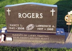
| Description | : | OSAGE - Nancy L. Rogers, 66, of Osage died Monday (Sept. 4, 2006) at the Mitchell County Regional Health Center-Hospice Unit in Osage surrounded by her family.Nancy was born on Jan. 2, 1940, in Scranton, Pa., the daughter of Norris and Leah (Bartelson) Scott. She was united in marriage to Lawrence A. Rogers on July 20, 1957, in South Sterling, Pa. Nancy and Lawrence farmed for many years southwest of Osage. She worked for the last 10 years at the west Casey's in Osage as a pizzamaker until her recent retirement.She was a longtime member of the First United Methodist... Read More |
frequently asked questions (FAQ):
-
Where is Nancy L. Scott Rogers's memorial?
Nancy L. Scott Rogers's memorial is located at: Osage Cemetery, Osage, Mitchell County, USA.
-
When did Nancy L. Scott Rogers death?
Nancy L. Scott Rogers death on 4 Sep 2006 in Osage, Mitchell County, Iowa, USA
-
Where are the coordinates of the Nancy L. Scott Rogers's memorial?
Latitude: 43.2916700
Longitude: -92.8201700
Family Members:
Parent
Spouse
Siblings
Children

Flowers:


Nearby Cemetories:
1. Osage Cemetery
Osage, Mitchell County, USA
Coordinate: 43.2916700, -92.8201700
2. Sacred Heart Cemetery
Osage, Mitchell County, USA
Coordinate: 43.2742004, -92.7917023
3. South Osage Mennonite Church Cemetery
Osage, Mitchell County, USA
Coordinate: 43.2544556, -92.7915573
4. Tucker Cemetery
Osage, Mitchell County, USA
Coordinate: 43.2494011, -92.8319016
5. Oak Grove Cemetery
Mitchell, Mitchell County, USA
Coordinate: 43.3156013, -92.8707962
6. Calvary Cemetery
Osage, Mitchell County, USA
Coordinate: 43.2238998, -92.8300018
7. Orchard Cemetery
Orchard, Mitchell County, USA
Coordinate: 43.2249985, -92.7838898
8. Dudley Cemetery
Dudley (historical), Mitchell County, USA
Coordinate: 43.2252998, -92.8743973
9. Riverview Cemetery
Saint Ansgar, Mitchell County, USA
Coordinate: 43.3430328, -92.9220200
10. Rock Creek Cemetery
Meroa, Mitchell County, USA
Coordinate: 43.2352791, -92.9225006
11. Eden Presbyterian Cemetery
Meroa, Mitchell County, USA
Coordinate: 43.2131004, -92.9103012
12. West End Cemetery
Meroa, Mitchell County, USA
Coordinate: 43.2216682, -92.9250031
13. Saint Ansgar Cemetery
Saint Ansgar, Mitchell County, USA
Coordinate: 43.3777809, -92.9094391
14. Immanuel Lutheran Cemetery
Saint Ansgar, Mitchell County, USA
Coordinate: 43.3717003, -92.9257965
15. First Lutheran Cemetery
Saint Ansgar, Mitchell County, USA
Coordinate: 43.3841705, -92.9194412
16. Liberty Cemetery
Little Cedar, Mitchell County, USA
Coordinate: 43.3856010, -92.7230988
17. Beaver Creek Cemetery
Brownville, Mitchell County, USA
Coordinate: 43.3397217, -92.6727829
18. Blakestad Cemetery
Saint Ansgar, Mitchell County, USA
Coordinate: 43.3711014, -92.9400024
19. Saint Johns Lutheran Cemetery
Rock Creek, Mitchell County, USA
Coordinate: 43.3295560, -92.9849770
20. Saint Peters Cemetery
New Haven, Mitchell County, USA
Coordinate: 43.2858315, -92.6427765
21. Saint Johns Lutheran Old Cemetery
Rock Creek, Mitchell County, USA
Coordinate: 43.3313904, -92.9897232
22. Stillwater Cemetery
Orchard, Mitchell County, USA
Coordinate: 43.2130585, -92.6780624
23. McKinley Cemetery
Saint Ansgar, Mitchell County, USA
Coordinate: 43.3906400, -92.9368300
24. Howardville Cemetery
Floyd, Floyd County, USA
Coordinate: 43.1866989, -92.7016983