
| Birth | : | 20 Mar 1924 Fresno, Fresno County, California, USA |
| Death | : | 18 Oct 2017 Yolo County, California, USA |
| Burial | : | Davis Cemetery, Davis, Yolo County, USA |
| Coordinate | : | 38.5550003, -121.7260971 |
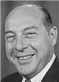
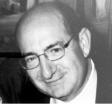
| Description | : | Nanele Faye Arnold March 20, 1924 — Oct. 18, 2017 Nanele Faye Arnold, age 93, died peacefully at home on Wednesday, Oct. 18, 2017. Nanele grew up in Sacramento and graduated from Sacramento High School in 1941. In October 1941, she married her high-school sweetheart, Bill, and they were married for 70 years until his death in 2012. In 1955, Bill purchased the Pontiac dealership, then located at First and F Streets in Davis. Nanele ran the office. Bill was President of the Davis Chamber of Commerce in 1958 and later both their son, Doug, and granddaughter Cary Arnold were elected as presidents of... Read More |
frequently asked questions (FAQ):
-
Where is Nanele Faye Brown Arnold's memorial?
Nanele Faye Brown Arnold's memorial is located at: Davis Cemetery, Davis, Yolo County, USA.
-
When did Nanele Faye Brown Arnold death?
Nanele Faye Brown Arnold death on 18 Oct 2017 in Yolo County, California, USA
-
Where are the coordinates of the Nanele Faye Brown Arnold's memorial?
Latitude: 38.5550003
Longitude: -121.7260971
Family Members:
Parent

Spouse
Siblings
Children
Flowers:


Nearby Cemetories:
1. Davis Cemetery
Davis, Yolo County, USA
Coordinate: 38.5550003, -121.7260971
2. Episcopal Church of Saint Martin Columbarium
Davis, Yolo County, USA
Coordinate: 38.5488870, -121.7611850
3. Tremont Cemetery
Dixon, Solano County, USA
Coordinate: 38.4940987, -121.7043991
4. Saint Joseph Cemetery
Woodland, Yolo County, USA
Coordinate: 38.6694400, -121.7842120
5. Woodland Cemetery
Woodland, Yolo County, USA
Coordinate: 38.6711006, -121.7846985
6. Dixon Cemetery
Dixon, Solano County, USA
Coordinate: 38.4354553, -121.8227005
7. Monument Hill Memorial Park
Woodland, Yolo County, USA
Coordinate: 38.6781020, -121.8566400
8. Sunset Hill Cemetery
Sacramento, Sacramento County, USA
Coordinate: 38.5608000, -121.5037300
9. Masonic Lawn Cemetery
Sacramento, Sacramento County, USA
Coordinate: 38.5604720, -121.5032600
10. Odd Fellows Lawn Cemetery and Mausoleum
Sacramento, Sacramento County, USA
Coordinate: 38.5585000, -121.5011000
11. Sacramento City Cemetery
Sacramento, Sacramento County, USA
Coordinate: 38.5636864, -121.5009537
12. National Shrine of Our Lady of Guadalupe Crypt
Sacramento, Sacramento County, USA
Coordinate: 38.5704800, -121.5014400
13. Buddhist Church of Sacramento Nokotsudo
Sacramento, Sacramento County, USA
Coordinate: 38.5639300, -121.4978400
14. Sacramento Valley National Cemetery
Dixon, Solano County, USA
Coordinate: 38.4167800, -121.8754000
15. California State Capitol
Sacramento, Sacramento County, USA
Coordinate: 38.5760994, -121.4931488
16. Holy Ascension Russian Orthodox Cemetery
Sacramento, Sacramento County, USA
Coordinate: 38.5846212, -121.4936736
17. Saint Joseph Cemetery
Sacramento, Sacramento County, USA
Coordinate: 38.5574989, -121.4835968
18. Cacheville Cemetery
Yolo, Yolo County, USA
Coordinate: 38.7378300, -121.8090200
19. Pho Minh Temple Columbarium
Sacramento, Sacramento County, USA
Coordinate: 38.5340100, -121.4769000
20. Trinity Episcopal Cathedral Columbarium
Sacramento, Sacramento County, USA
Coordinate: 38.5705500, -121.4723770
21. Winters Cemetery
Winters, Yolo County, USA
Coordinate: 38.5256004, -121.9777985
22. Gordon Family Cemetery
Esparto, Yolo County, USA
Coordinate: 38.6966060, -121.9151540
23. Saint Rose Cemetery (Defunct)
Sacramento, Sacramento County, USA
Coordinate: 38.5208015, -121.4672012
24. New Helvetia Cemetery (Defunct)
Sacramento, Sacramento County, USA
Coordinate: 38.5731600, -121.4639900