
| Memorials | : | 603 |
| Location | : | Sacramento, Sacramento County, USA |
| Coordinate | : | 38.5731600, -121.4639900 |
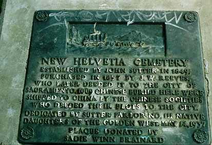
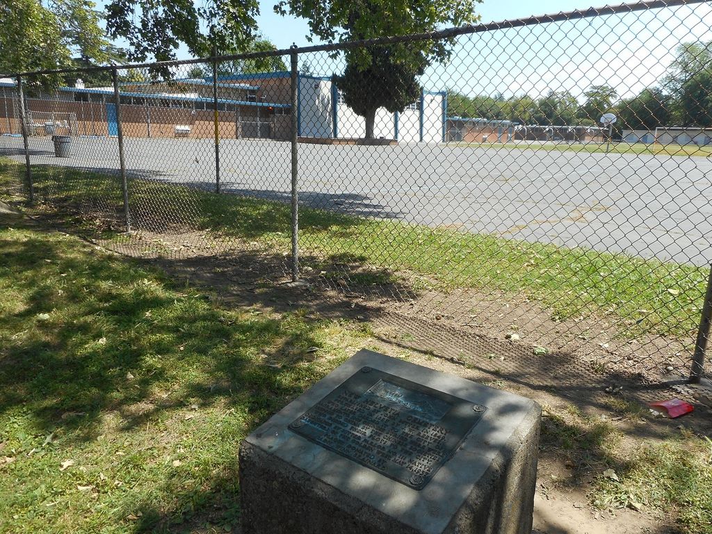
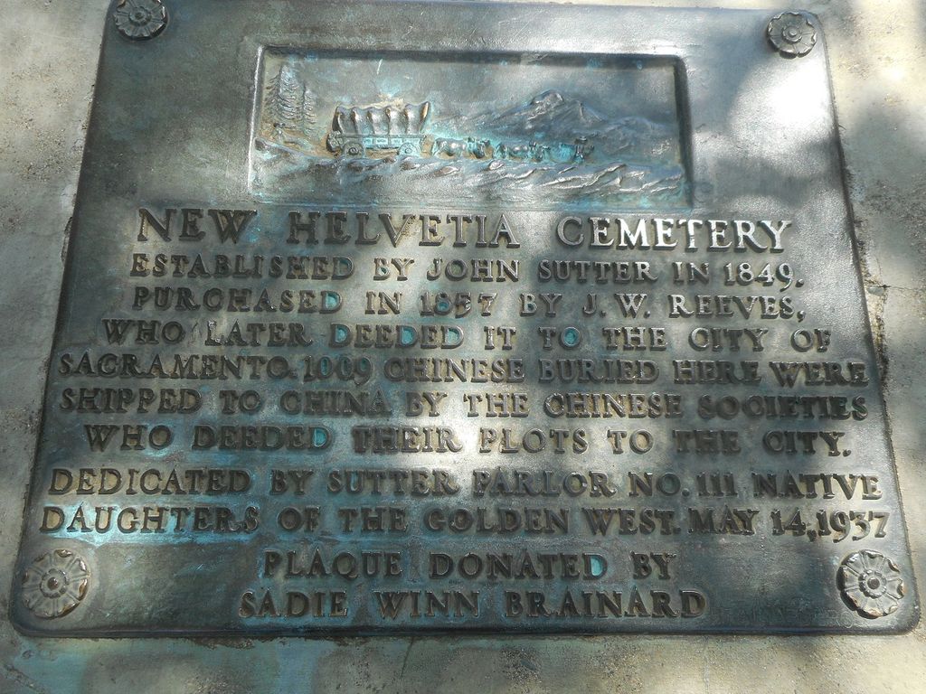
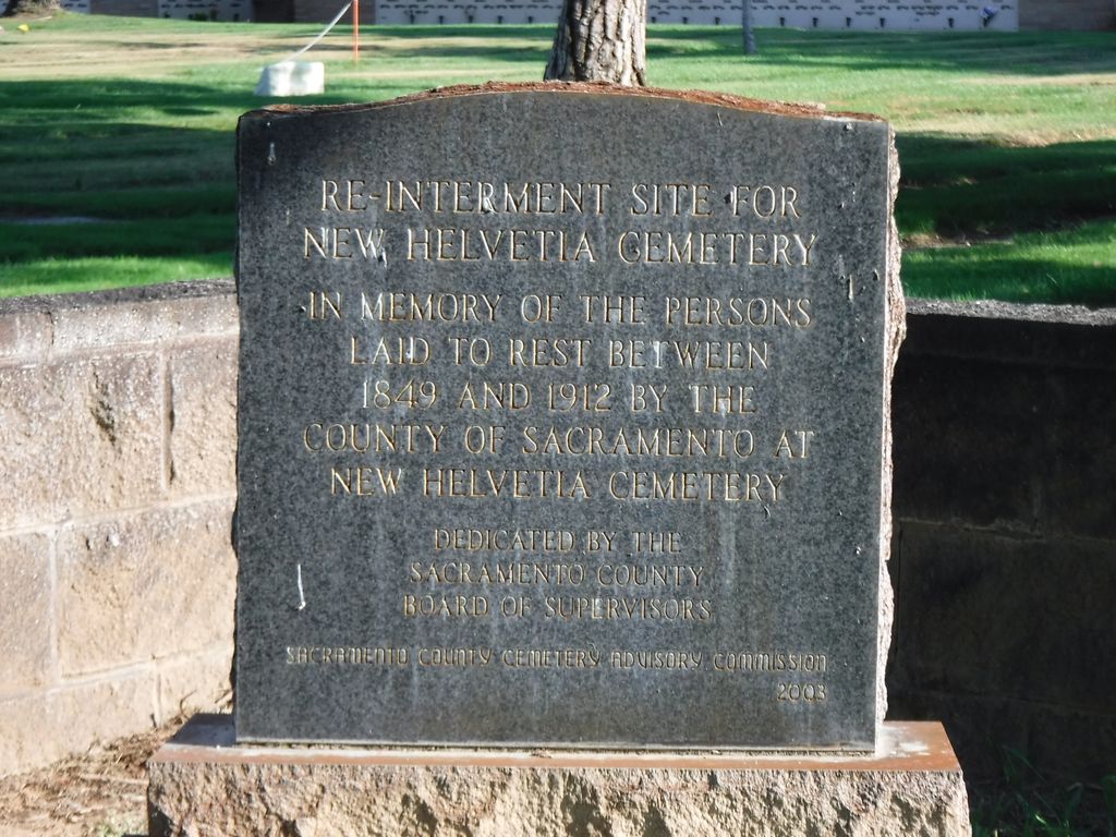
| Description | : | Established in 1849 by Capt. John Sutter, it was the first cemetery in Sacramento. In 1956, all burials were removed from the cemetery and relocated primarily to Sacramento City Cemetery or East Lawn Memorial Park. New Helvetia Cemetery (1845-1956) was contiguous with the (Sutter's) Fort Burying Ground, established in the early 1840's and served as Sacramento's first cemetery until 1849. Starting in 1916, most of the beautiful hand-carved monuments were replaced with flat concrete markers in order to turn the cemetery into a park. In the mid 1950's when land was needed to build Sutter Middle School over 5,000 early settlers and... Read More |
frequently asked questions (FAQ):
-
Where is New Helvetia Cemetery (Defunct)?
New Helvetia Cemetery (Defunct) is located at Sacramento, Sacramento County ,California ,USA.
-
New Helvetia Cemetery (Defunct) cemetery's updated grave count on graveviews.com?
51 memorials
-
Where are the coordinates of the New Helvetia Cemetery (Defunct)?
Latitude: 38.5731600
Longitude: -121.4639900
Nearby Cemetories:
1. Trinity Episcopal Cathedral Columbarium
Sacramento, Sacramento County, USA
Coordinate: 38.5705500, -121.4723770
2. East Lawn Memorial Park
Sacramento, Sacramento County, USA
Coordinate: 38.5612960, -121.4492760
3. Saint Joseph Cemetery
Sacramento, Sacramento County, USA
Coordinate: 38.5574989, -121.4835968
4. California State Capitol
Sacramento, Sacramento County, USA
Coordinate: 38.5760994, -121.4931488
5. Holy Ascension Russian Orthodox Cemetery
Sacramento, Sacramento County, USA
Coordinate: 38.5846212, -121.4936736
6. Buddhist Church of Sacramento Nokotsudo
Sacramento, Sacramento County, USA
Coordinate: 38.5639300, -121.4978400
7. National Shrine of Our Lady of Guadalupe Crypt
Sacramento, Sacramento County, USA
Coordinate: 38.5704800, -121.5014400
8. Sacramento City Cemetery
Sacramento, Sacramento County, USA
Coordinate: 38.5636864, -121.5009537
9. Odd Fellows Lawn Cemetery and Mausoleum
Sacramento, Sacramento County, USA
Coordinate: 38.5585000, -121.5011000
10. Masonic Lawn Cemetery
Sacramento, Sacramento County, USA
Coordinate: 38.5604720, -121.5032600
11. Sunset Hill Cemetery
Sacramento, Sacramento County, USA
Coordinate: 38.5608000, -121.5037300
12. Pho Minh Temple Columbarium
Sacramento, Sacramento County, USA
Coordinate: 38.5340100, -121.4769000
13. Saint Rose Cemetery (Defunct)
Sacramento, Sacramento County, USA
Coordinate: 38.5208015, -121.4672012
14. Saint Mary's Catholic Cemetery and Mausoleum
Sacramento, Sacramento County, USA
Coordinate: 38.5298900, -121.4261200
15. Sacramento County Hospital Cemetery
Sacramento, Sacramento County, USA
Coordinate: 38.5289300, -121.4239100
16. Russian Orthodox Cemetery
Sacramento, Sacramento County, USA
Coordinate: 38.5268800, -121.4244300
17. Sacramento County Cemetery
Sacramento County, USA
Coordinate: 38.5267900, -121.4233700
18. Sacramento County Veterans Memorial Cemetery
Sacramento, Sacramento County, USA
Coordinate: 38.5252838, -121.4239120
19. Sacramento Memorial Lawn Cemetery
Sacramento, Sacramento County, USA
Coordinate: 38.5146484, -121.4380341
20. Home of Peace Cemetery
Sacramento, Sacramento County, USA
Coordinate: 38.5137558, -121.4382782
21. Kim Quang Temple Columbarium
Sacramento, Sacramento County, USA
Coordinate: 38.5996600, -121.3904700
22. Tinh Xa Ngoc An Temple Columbarium
Sacramento, Sacramento County, USA
Coordinate: 38.5190200, -121.4159500
23. Elder Creek Cemetery
Florin, Sacramento County, USA
Coordinate: 38.5111008, -121.4169006
24. Saint Marks Methodist Church Memorial Tree
Sacramento, Sacramento County, USA
Coordinate: 38.6076500, -121.3750680