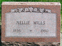
Natalie Nellie Sharp Mills
| Birth | : | 23 Apr 1896 Missouri, USA |
| Death | : | 7 May 1980 Orrick, Ray County, Missouri, USA |
| Burial | : | Massachusetts National Cemetery, Bourne, Barnstable County, USA |
| Coordinate | : | 41.6759987, -70.5824966 |
frequently asked questions (FAQ):
-
Where is Natalie Nellie Sharp Mills's memorial?
Natalie Nellie Sharp Mills's memorial is located at: Massachusetts National Cemetery, Bourne, Barnstable County, USA.
-
When did Natalie Nellie Sharp Mills death?
Natalie Nellie Sharp Mills death on 7 May 1980 in Orrick, Ray County, Missouri, USA
-
Where are the coordinates of the Natalie Nellie Sharp Mills's memorial?
Latitude: 41.6759987
Longitude: -70.5824966
Family Members:
Parent
Spouse
Siblings
Children
Flowers:
Nearby Cemetories:
1. Massachusetts National Cemetery
Bourne, Barnstable County, USA
Coordinate: 41.6759987, -70.5824966
2. Cataumet Cemetery
Bourne, Barnstable County, USA
Coordinate: 41.6768990, -70.6063995
3. Otis Memorial
Bourne, Barnstable County, USA
Coordinate: 41.6596980, -70.5706980
4. Pocasset Cemetery
Bourne, Barnstable County, USA
Coordinate: 41.6947260, -70.6034070
5. Amrita Island Mausoleum
Bourne, Barnstable County, USA
Coordinate: 41.6593900, -70.6207900
6. North Falmouth Burying Ground
North Falmouth, Barnstable County, USA
Coordinate: 41.6425018, -70.6167984
7. Monument Beach Cemetery
Monument Beach, Barnstable County, USA
Coordinate: 41.7151800, -70.6094600
8. Animal Inn Pet Cemetery
Forestdale, Barnstable County, USA
Coordinate: 41.6754200, -70.5070100
9. Forestdale Cemetery
Forestdale, Barnstable County, USA
Coordinate: 41.6903000, -70.5024033
10. Monument Neck Cemetery
Gray Gables, Barnstable County, USA
Coordinate: 41.7346001, -70.6128006
11. Old Bourne Cemetery
Bourne, Barnstable County, USA
Coordinate: 41.7386017, -70.5986023
12. Oakland Grove Cemetery
Bourne, Barnstable County, USA
Coordinate: 41.7402992, -70.6042023
13. Bourne Village Cemetery
Bourne, Barnstable County, USA
Coordinate: 41.7425117, -70.5938110
14. Falmouth Jewish Cemetery
East Falmouth, Barnstable County, USA
Coordinate: 41.6080710, -70.5673800
15. East End Burying Ground
East Falmouth, Barnstable County, USA
Coordinate: 41.6059400, -70.5682900
16. Crowell Cemetery
Falmouth, Barnstable County, USA
Coordinate: 41.6128900, -70.6258200
17. Tobey Cemetery
Forestdale, Barnstable County, USA
Coordinate: 41.6972008, -70.4875031
18. Attaquin Cemetery
Mashpee, Barnstable County, USA
Coordinate: 41.6517296, -70.4883881
19. Francis Family Cemetery
Mashpee, Barnstable County, USA
Coordinate: 41.6807900, -70.4816600
20. Bourne Family Cemetery
Bourne, Barnstable County, USA
Coordinate: 41.7501602, -70.6032104
21. Sandwich Town Cemetery
Sandwich, Barnstable County, USA
Coordinate: 41.7125300, -70.4909000
22. Long Neck Cemetery
Wareham, Plymouth County, USA
Coordinate: 41.7461014, -70.6369019
23. Lakewood Cemetery
Mashpee, Barnstable County, USA
Coordinate: 41.6530991, -70.4783020
24. Wakeby Cemetery
Sandwich, Barnstable County, USA
Coordinate: 41.6725500, -70.4723100

