
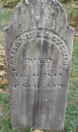
Nathaniel Hutchins
| Birth | : | 22 Jun 1771 |
| Death | : | 16 Jan 1849 |
| Burial | : | Blackley Jewish Cemetery, Blackley, Metropolitan Borough of Manchester, England |
| Coordinate | : | 53.5299377, -2.2097650 |
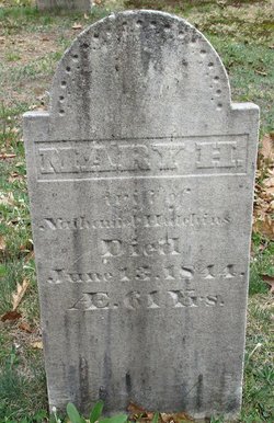
| Description | : | Born 22 June 1771, birth recorded at Fryeburg (gravestone indicates a birth date of 1767); died 16 January 1849 (age 81 yrs, 7 mos), in Stow; buried with second wife at Hillcrest Cemetery, Stow; Married (1), 12 June 1794, at Warner, NH: ESTHER BRADLEY of Hopkinton, NH. Married (2), 6 July 1818, at Chatham, NH: MARY (HARRIMAN) CHANDLER, daughter of Amos & Nancy Harriman of Chatham, and widow of John Chandler (1781-1815) of North Chatham. Mary was born about 1783, and died 13 June 1844. Nathaniel was a resident of Chatham in 1794, Fryeburg in 1800, Lovell in 1820 and... Read More |
frequently asked questions (FAQ):
-
Where is Nathaniel Hutchins's memorial?
Nathaniel Hutchins's memorial is located at: Blackley Jewish Cemetery, Blackley, Metropolitan Borough of Manchester, England.
-
When did Nathaniel Hutchins death?
Nathaniel Hutchins death on 16 Jan 1849 in
-
Where are the coordinates of the Nathaniel Hutchins's memorial?
Latitude: 53.5299377
Longitude: -2.2097650
Family Members:
Parent

Spouse
Siblings
Children
Flowers:


Nearby Cemetories:
1. Blackley Jewish Cemetery
Blackley, Metropolitan Borough of Manchester, England
Coordinate: 53.5299377, -2.2097650
2. St. Peter's Churchyard
Blackley, Metropolitan Borough of Manchester, England
Coordinate: 53.5231200, -2.2188900
3. Blackley Presbyterian Chapel Chapelyard
Blackley, Metropolitan Borough of Manchester, England
Coordinate: 53.5233100, -2.2248110
4. All Saints Churchyard Rhodes
Middleton, Metropolitan Borough of Rochdale, England
Coordinate: 53.5437200, -2.2261400
5. Blackley Cemetery and Crematorium
Blackley, Metropolitan Borough of Manchester, England
Coordinate: 53.5333176, -2.2394190
6. Christchurch Harpurhey Churchyard
Harpurhey, Metropolitan Borough of Manchester, England
Coordinate: 53.5115100, -2.2134800
7. St. Joseph's Roman Catholic Churchyard
Moston, Metropolitan Borough of Manchester, England
Coordinate: 53.5149270, -2.1877070
8. Crumpsall Jewish Cemetery
Crumpsall, Metropolitan Borough of Manchester, England
Coordinate: 53.5124250, -2.2280270
9. St. Michael's Churchyard
Middleton, Metropolitan Borough of Rochdale, England
Coordinate: 53.5476600, -2.1907240
10. Saint Mary's Churchyard
Moston, Metropolitan Borough of Manchester, England
Coordinate: 53.5181740, -2.1763410
11. Manchester General Cemetery
Manchester, Metropolitan Borough of Manchester, England
Coordinate: 53.5062710, -2.2179570
12. St Leonard's Churchyard
Middleton, Metropolitan Borough of Rochdale, England
Coordinate: 53.5530640, -2.1945060
13. Old Burial Grounds
Middleton, Metropolitan Borough of Rochdale, England
Coordinate: 53.5534036, -2.1948053
14. St. Gabriel's Churchyard
Middleton, Metropolitan Borough of Rochdale, England
Coordinate: 53.5446736, -2.1742074
15. Wesleyan Methodist Cemetery
Crumpsall, Metropolitan Borough of Manchester, England
Coordinate: 53.5142870, -2.2447610
16. St. Marks' Churchyard
Cheetham Hill, Metropolitan Borough of Manchester, England
Coordinate: 53.5113780, -2.2462660
17. St Luke's Churchyard
Cheetham Hill, Metropolitan Borough of Manchester, England
Coordinate: 53.5041660, -2.2354680
18. Middleton Cemetery and Crematorium
Middleton, Metropolitan Borough of Rochdale, England
Coordinate: 53.5574400, -2.1829200
19. Boarshaw Cemetery and Crematorium
Middleton, Metropolitan Borough of Rochdale, England
Coordinate: 53.5584100, -2.1773100
20. All Saints Churchyard
Newton Heath, Metropolitan Borough of Manchester, England
Coordinate: 53.5002260, -2.1777970
21. St. Mary's Churchyard Birch-In-Hopwood
Heywood, Metropolitan Borough of Rochdale, England
Coordinate: 53.5662410, -2.2247560
22. St Paul's Churchyard
Salford, Metropolitan Borough of Salford, England
Coordinate: 53.5148800, -2.2725500
23. Philips Park Cemetery
Miles Platting, Metropolitan Borough of Manchester, England
Coordinate: 53.4898020, -2.2007400
24. Chadderton Cemetery
Chadderton, Metropolitan Borough of Oldham, England
Coordinate: 53.5464860, -2.1468960