
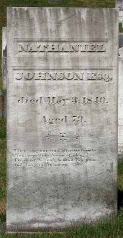
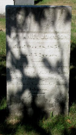
Nathaniel Johnson
| Birth | : | 6 Mar 1761 Holliston, Middlesex County, Massachusetts, USA |
| Death | : | 3 May 1840 Holliston, Middlesex County, Massachusetts, USA |
| Burial | : | Bath Abbey, Bath, Bath and North East Somerset Unitary Authority, England |
| Coordinate | : | 51.3815310, -2.3586640 |
| Inscription | : | NATHANIEL JOHNSON ESQ. died May 3, 1840, Aged 79. When languor and disease invade, This trembling house of clay, 'Tis sweet to look beyond my pains, And long to fly away. |
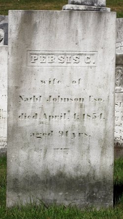
| Description | : | Holliston births: JOHNSON, Nathaniel, s. David and Kezia, Mar. 6, 1761. [Nathaniell. CR1] Holliston intentions: JOHNSON, Nathaniel and Persis Gibbs of Hopkinston, int. Dec. 24, 1784. Hopkinston marriages: JOHNSON, Nathaniel of Holiston, and Perses Gibbs, int. [Dec.] 30 [1784]. [Persis, m. Jan. 30, 1785, C.R.1.] Holliston deaths: JOHNSON, Nathaniel Esq., May 3, 1840, a. 79. ["formerly a man of much influence," dropsy. CR1] |
frequently asked questions (FAQ):
-
Where is Nathaniel Johnson's memorial?
Nathaniel Johnson's memorial is located at: Bath Abbey, Bath, Bath and North East Somerset Unitary Authority, England.
-
When did Nathaniel Johnson death?
Nathaniel Johnson death on 3 May 1840 in Holliston, Middlesex County, Massachusetts, USA
-
Where are the coordinates of the Nathaniel Johnson's memorial?
Latitude: 51.3815310
Longitude: -2.3586640
Family Members:
Parent
Spouse
Children
Flowers:


Nearby Cemetories:
1. Bath Abbey
Bath, Bath and North East Somerset Unitary Authority, England
Coordinate: 51.3815310, -2.3586640
2. St. Mary de Stall Churchyard (Defunct)
Bath, Bath and North East Somerset Unitary Authority, England
Coordinate: 51.3813350, -2.3600353
3. Quaker Meeting House
Bath, Bath and North East Somerset Unitary Authority, England
Coordinate: 51.3823280, -2.3604380
4. Old Orchard Street Catholic Burial Vault
Bath, Bath and North East Somerset Unitary Authority, England
Coordinate: 51.3800370, -2.3579910
5. Bath General Hospital Burial Ground
Bath and North East Somerset Unitary Authority, England
Coordinate: 51.3824715, -2.3614742
6. Ss Michael & Paul Churchyard
Bath, Bath and North East Somerset Unitary Authority, England
Coordinate: 51.3834970, -2.3596980
7. St James Old Burial Ground
Bath, Bath and North East Somerset Unitary Authority, England
Coordinate: 51.3798600, -2.3610100
8. St. Michael's Burial Ground
Bath, Bath and North East Somerset Unitary Authority, England
Coordinate: 51.3838810, -2.3594090
9. St Mary's Chapel, Queens Square
Bath, Bath and North East Somerset Unitary Authority, England
Coordinate: 51.3827790, -2.3649790
10. Saint Mark's Churchyard
Widcombe, Bath and North East Somerset Unitary Authority, England
Coordinate: 51.3766660, -2.3588010
11. Baptist Burial Ground
Widcombe, Bath and North East Somerset Unitary Authority, England
Coordinate: 51.3764216, -2.3556947
12. St Mary Magdalen Chapel
Widcombe, Bath and North East Somerset Unitary Authority, England
Coordinate: 51.3760486, -2.3643405
13. Old Baptist Burial Ground
Walcot, Bath and North East Somerset Unitary Authority, England
Coordinate: 51.3755070, -2.3544360
14. St. Mary's Churchyard
Bathwick, Bath and North East Somerset Unitary Authority, England
Coordinate: 51.3876120, -2.3543540
15. Abbey & St James' Graveyard for the Poor
Widcombe, Bath and North East Somerset Unitary Authority, England
Coordinate: 51.3753550, -2.3545640
16. St. Swithin Churchyard
Bath, Bath and North East Somerset Unitary Authority, England
Coordinate: 51.3885480, -2.3594500
17. St. John the Baptist Churchyard
Bathwick, Bath and North East Somerset Unitary Authority, England
Coordinate: 51.3886890, -2.3547030
18. Walcot Methodist Chapel Burial Ground
Bath, Bath and North East Somerset Unitary Authority, England
Coordinate: 51.3897080, -2.3579610
19. St. James' Cemetery
Bath, Bath and North East Somerset Unitary Authority, England
Coordinate: 51.3802000, -2.3722200
20. Quaker Burial Ground
Widcombe, Bath and North East Somerset Unitary Authority, England
Coordinate: 51.3744350, -2.3498460
21. St Thomas à Becket's Church
Widcombe, Bath and North East Somerset Unitary Authority, England
Coordinate: 51.3734250, -2.3465560
22. Smallcombe Vale Cemetery
Bathwick, Bath and North East Somerset Unitary Authority, England
Coordinate: 51.3757400, -2.3429400
23. Independent Burial Ground Argyle Chapel
Bath, Bath and North East Somerset Unitary Authority, England
Coordinate: 51.3925420, -2.3536920
24. Unitarian Chapel Burial Ground
Widcombe, Bath and North East Somerset Unitary Authority, England
Coordinate: 51.3704650, -2.3539270