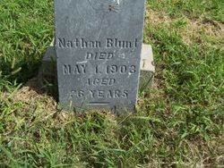
Nathaniel “Nathan” Blunt
| Birth | : | 20 Aug 1826 Henrico County, Virginia, USA |
| Death | : | 1 May 1903 Troy, Doniphan County, Kansas, USA |
| Burial | : | Baptist Village Cemetery, East Longmeadow, Hampden County, USA |
| Coordinate | : | 42.0559920, -72.4711310 |
| Inscription | : | Died May 1, 1903, Aged 76 yrs. |
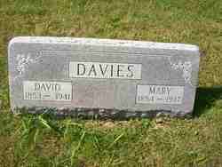
| Description | : | The cemetery reading listed him as Nathan Blurt, but the correct surname certainly would seem to be Blunt. The connection to his father, Joseph Blunt, was made at the request of Findagrave contributor Nathan Haines. Per the 1900 Census, Kansas, Doniphan County, Center Twp; Davis, Shelby?, head, age 26, Kansas, Kansas, Ind. Davis, Maggie, wife, age 23, married 5 yrs., 1 child, Iowa, Ohio, Ohio Davis, Walter?, son, age 2, Kansas Blunt, Nathan, grandfather, Aug. 1826, age 73, Va., Ind., Va. Note: Shelby and Maggie are also buried here, but under the surname Davies. |
frequently asked questions (FAQ):
-
Where is Nathaniel “Nathan” Blunt's memorial?
Nathaniel “Nathan” Blunt's memorial is located at: Baptist Village Cemetery, East Longmeadow, Hampden County, USA.
-
When did Nathaniel “Nathan” Blunt death?
Nathaniel “Nathan” Blunt death on 1 May 1903 in Troy, Doniphan County, Kansas, USA
-
Where are the coordinates of the Nathaniel “Nathan” Blunt's memorial?
Latitude: 42.0559920
Longitude: -72.4711310
Family Members:
Parent
Siblings
Children
Flowers:
Nearby Cemetories:
1. Baptist Village Cemetery
East Longmeadow, Hampden County, USA
Coordinate: 42.0559920, -72.4711310
2. Billings Hill Cemetery
East Longmeadow, Hampden County, USA
Coordinate: 42.0433860, -72.5000000
3. Saint Marks Memorial Garden
East Longmeadow, Hampden County, USA
Coordinate: 42.0725600, -72.5007430
4. Green Lawn Cemetery
East Longmeadow, Hampden County, USA
Coordinate: 42.0645561, -72.5079727
5. Brookside Cemetery
East Longmeadow, Hampden County, USA
Coordinate: 42.0842819, -72.4809036
6. Old Hampden Cemetery
Hampden, Hampden County, USA
Coordinate: 42.0611000, -72.4111023
7. Wachogue Cemetery
Springfield, Hampden County, USA
Coordinate: 42.0950860, -72.5109030
8. Gate of Heaven Cemetery
Springfield, Hampden County, USA
Coordinate: 42.1048370, -72.4778450
9. Prospect Hill Cemetery
Hampden, Hampden County, USA
Coordinate: 42.0639000, -72.4028015
10. Deer Creek Harmony Presbyterian Church Cemeter
Havre de Grace, Harford County, USA
Coordinate: 42.0636292, -72.4015503
11. Saint Marys Cemetery
Hampden, Hampden County, USA
Coordinate: 42.0636292, -72.4015503
12. Shaker Cemetery
Enfield, Hartford County, USA
Coordinate: 42.0141400, -72.5161600
13. Adams Cemetery
Wilbraham, Hampden County, USA
Coordinate: 42.1082993, -72.4389038
14. North Cemetery
Somers, Tolland County, USA
Coordinate: 41.9953003, -72.4492035
15. Unitarian Universalist Church Memorial Garden
Springfield, Hampden County, USA
Coordinate: 42.0711740, -72.5611830
16. Center Cemetery
Somers, Tolland County, USA
Coordinate: 41.9890900, -72.4391937
17. Davis Cemetery
Stafford, Tolland County, USA
Coordinate: 42.0134710, -72.3943690
18. Somers Congregational Church Memorial Garden
Somers, Tolland County, USA
Coordinate: 41.9857190, -72.4461100
19. West Cemetery
Somers, Tolland County, USA
Coordinate: 41.9836006, -72.4606018
20. Woodland Dell Cemetery
Wilbraham, Hampden County, USA
Coordinate: 42.1211014, -72.4263992
21. Kesser Israel Cemetery
Springfield, Hampden County, USA
Coordinate: 42.1145610, -72.5304670
22. Hillcrest Park Cemetery
Springfield, Hampden County, USA
Coordinate: 42.1274986, -72.4933014
23. Sons of Israel Cemetery
Springfield, Hampden County, USA
Coordinate: 42.1143000, -72.5316000
24. City of Homes Cemetery
Springfield, Hampden County, USA
Coordinate: 42.1142980, -72.5316060


