


Nell Bain Ponder
| Birth | : | 20 Oct 1927 Camden, Benton County, Tennessee, USA |
| Death | : | 8 Jun 2014 East Prairie, Mississippi County, Missouri, USA |
| Burial | : | Dogwood Cemetery, Dogwood, Mississippi County, USA |
| Coordinate | : | 36.8231316, -89.4546738 |
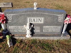
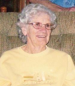
| Description | : | Nell Ponder October 20, 1927 - June 8, 2014 Nell Ponder Age 86 years, seven months and 18 days, a resident of East Prairie, passed away, Sunday, June 8, 2014, at 3:10 am in the East Prairie Nursing Center. Born October 20, 1927 in Camden, Tennessee to the late John Herman & Lillie Mae McMurtry Bain, Nell lived most of her life in Mississippi County. She was a member of the Nelson Memorial United Methodist Church in East Prairie. On March 5, 1933 in East Prairie she married Eugene F. (Gene) Ponder who survives of the home. Besides her husband she is survived... Read More |
frequently asked questions (FAQ):
-
Where is Nell Bain Ponder's memorial?
Nell Bain Ponder's memorial is located at: Dogwood Cemetery, Dogwood, Mississippi County, USA.
-
When did Nell Bain Ponder death?
Nell Bain Ponder death on 8 Jun 2014 in East Prairie, Mississippi County, Missouri, USA
-
Where are the coordinates of the Nell Bain Ponder's memorial?
Latitude: 36.8231316
Longitude: -89.4546738
Family Members:
Parent

Spouse

Siblings


Flowers:


Nearby Cemetories:
1. Dogwood Cemetery
Dogwood, Mississippi County, USA
Coordinate: 36.8231316, -89.4546738
2. Armer Cemetery
East Prairie, Mississippi County, USA
Coordinate: 36.8703003, -89.4608002
3. Big Opening Cemetery
New Madrid County, USA
Coordinate: 36.8089500, -89.5247100
4. Memorial Park Cemetery
East Prairie, Mississippi County, USA
Coordinate: 36.7837868, -89.3962479
5. Zilafro Cemetery
East Prairie, Mississippi County, USA
Coordinate: 36.7544960, -89.4100550
6. Greer Family Cemetery
Mississippi County, USA
Coordinate: 36.8017967, -89.3569275
7. Harper Cemetery
Mississippi County, USA
Coordinate: 36.7429200, -89.4150000
8. Pryor Cemetery
Mississippi County, USA
Coordinate: 36.7429680, -89.4147530
9. Bright Prospect Cemetery
Miner, Scott County, USA
Coordinate: 36.8844948, -89.5352707
10. Sikes Family Cemetery
Sikeston, New Madrid County, USA
Coordinate: 36.8410380, -89.5697350
11. Anniston Cemetery
Anniston, Mississippi County, USA
Coordinate: 36.8235100, -89.3336500
12. Bloomfield Cemetery
New Madrid County, USA
Coordinate: 36.7453003, -89.5382996
13. Calvary Cemetery
Charleston, Mississippi County, USA
Coordinate: 36.9212200, -89.3864000
14. Sikeston Memorial Park
Sikeston, New Madrid County, USA
Coordinate: 36.8630981, -89.5867004
15. Oak Grove Cemetery
Charleston, Mississippi County, USA
Coordinate: 36.9227982, -89.3858032
16. Sikeston City Cemetery
Sikeston, Scott County, USA
Coordinate: 36.8696442, -89.5867538
17. Dalton Cemetery
Charleston, Mississippi County, USA
Coordinate: 36.8698880, -89.3194700
18. Hart Cemetery
Miner, Scott County, USA
Coordinate: 36.8986015, -89.5721970
19. Calhoun Cemetery
Mississippi County, USA
Coordinate: 36.7672005, -89.3191986
20. Pulltight Cemetery
Pulltight, Mississippi County, USA
Coordinate: 36.7796300, -89.3108600
21. Matthews Cemetery
Matthews, New Madrid County, USA
Coordinate: 36.7496986, -89.5817032
22. Garden Of Memories Cemetery
Sikeston, Scott County, USA
Coordinate: 36.8650017, -89.6035995
23. Pleasant Valley Cemetery
Sikeston, Scott County, USA
Coordinate: 36.9418983, -89.5132980
24. Hunter Memorial Cemetery
Sikeston, Scott County, USA
Coordinate: 36.8844200, -89.5952800