
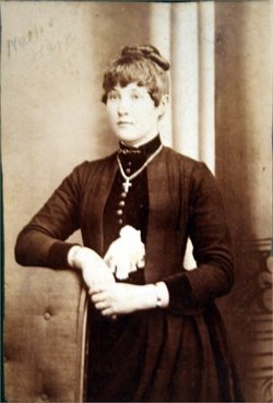
Nellie Eleanor Hain Squier
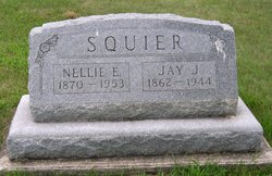
| Birth | : | 26 Sep 1870 Illinois, USA |
| Death | : | 13 Jan 1953 Rockford, Floyd County, Iowa, USA |
| Burial | : | Lakeside Cemetery, Port Huron, St. Clair County, USA |
| Coordinate | : | 43.0191994, -82.4357986 |
| Plot | : | Section 11 |
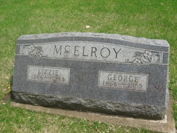
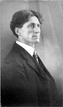
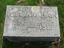
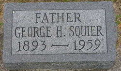
| Description | : | Rites Held for Mrs. Nellie Squier Friday Afternoon Funeral services for Mrs. Nellie Squier were held Friday afternoon, January 16th at 2 o'clock from the Methodist church, with the Reverend George W. Baker officiating. Mrs. Charles Clark was the organist and William Steuben sang "Beyond the Sunset" and "Some Day We'll Understand". Mrs. Very Carpee and Mrs. Esther Otto had charge of the floral tributes. Pallbearers were six grandsons, Roger, Truman, Wendell, Burr, Ronald, and Gene Squier. Interment was at Riverside cemetery, Blake Funeral Home in charge. Nellie Eleanor Squier, the second child of Sarah Vesta and George Henry Hain,... Read More |
frequently asked questions (FAQ):
-
Where is Nellie Eleanor Hain Squier's memorial?
Nellie Eleanor Hain Squier's memorial is located at: Lakeside Cemetery, Port Huron, St. Clair County, USA.
-
When did Nellie Eleanor Hain Squier death?
Nellie Eleanor Hain Squier death on 13 Jan 1953 in Rockford, Floyd County, Iowa, USA
-
Where are the coordinates of the Nellie Eleanor Hain Squier's memorial?
Latitude: 43.0191994
Longitude: -82.4357986
Family Members:
Parent
Spouse

Siblings
Children
Flowers:


Nearby Cemetories:
1. Mount Sinai Cemetery
Port Huron, St. Clair County, USA
Coordinate: 43.0167007, -82.4328003
2. Mount Hope Cemetery
Port Huron, St. Clair County, USA
Coordinate: 43.0236015, -82.4385986
3. Allied Veterans Memorial Cemetery
Port Huron, St. Clair County, USA
Coordinate: 43.0248985, -82.4359970
4. Lakeview Cemetery
Sarnia, Lambton County, Canada
Coordinate: 42.9965520, -82.3875890
5. Our Lady of Mercy Cemetery
Sarnia, Lambton County, Canada
Coordinate: 42.9982452, -82.3846283
6. Sunset Memorial Gardens Cemetery
Fort Gratiot Township, St. Clair County, USA
Coordinate: 43.0384540, -82.4893960
7. Lakeshore Presbyterian Columbarium
Fort Gratiot Township, St. Clair County, USA
Coordinate: 43.0608610, -82.4612930
8. Harrington Cemetery
Port Huron Township, St. Clair County, USA
Coordinate: 43.0030840, -82.4949480
9. Our Saviour Lutheran Church Columbarium
Port Huron, St. Clair County, USA
Coordinate: 42.9727670, -82.4263990
10. First Congregational Church Columbarium
Port Huron, St. Clair County, USA
Coordinate: 42.9717420, -82.4278690
11. Grace Episcopal Church Columbarium
Port Huron, St. Clair County, USA
Coordinate: 42.9715990, -82.4260910
12. Woodland Cemetery
Port Huron, St. Clair County, USA
Coordinate: 42.9820000, -82.4790000
13. Blackwell United Church Cemetery
Sarnia, Lambton County, Canada
Coordinate: 43.0209550, -82.3172070
14. Kinney Cemetery
Wadhams, St. Clair County, USA
Coordinate: 43.0018997, -82.5535965
15. Aamjiwnaang First Nations Cemetery
Sarnia, Lambton County, Canada
Coordinate: 42.9311600, -82.4330200
16. Resurrection Cemetery
Sarnia, Lambton County, Canada
Coordinate: 42.9821701, -82.3155746
17. Lakeport Cemetery
Burtchville Township, St. Clair County, USA
Coordinate: 43.1148872, -82.4949417
18. Froomfield Early Settlers Cemetery
Froomfield, Lambton County, Canada
Coordinate: 42.9093900, -82.4536400
19. Froomfield United Cemetery
Froomfield, Lambton County, Canada
Coordinate: 42.9093700, -82.4534440
20. Kimball Township Cemetery
Kimball, St. Clair County, USA
Coordinate: 42.9480360, -82.5624700
21. Ruby Cemetery
Ruby, St. Clair County, USA
Coordinate: 43.0377998, -82.5988998
22. Smith Blackstock Road Cemetery
Kimball, St. Clair County, USA
Coordinate: 42.9058930, -82.5096090
23. Irwin Cemetery
Bunyan, Lambton County, Canada
Coordinate: 42.9586500, -82.2820100
24. Saint Marys Cemetery
Marysville, St. Clair County, USA
Coordinate: 42.9028015, -82.5113983