
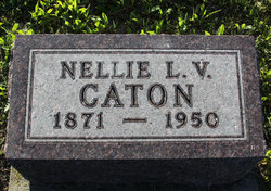
Nellie L. Vandergrift Caton
| Birth | : | 30 Sep 1871 Pittsburgh, Allegheny County, Pennsylvania, USA |
| Death | : | 31 Jul 1950 Miles City, Custer County, Montana, USA |
| Burial | : | Beaver Lodge Cemetery, Ekalaka, Carter County, USA |
| Coordinate | : | 45.8847008, -104.5522003 |
| Plot | : | Blk 6 - Row 2 - Lot 4 b |
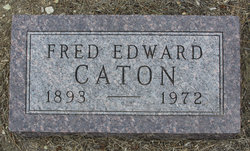
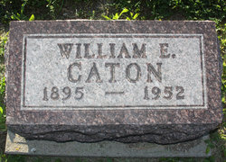
| Description | : | Nellie L. Vandergrift is the daughter of John Vandergrift and Mary Margaret Johnson. Nellie married Fred Edward Caton 4 Oct 1890 at Yankton, Yankton County, South Dakota. Nellie and Fred had children named Robert Van Der Grift Caton, Katherine Marie "Kittie", Fred Edward Caton Jr, William Edward, Nellie M. and David Eugene Caton. Nellie Vandergrift and Fred were divorced before 1908 and Fred moved to Mexico where he died and was buried in 1915. Nellie married Gilbert Warren Denigar 19 Sep 1908 at Ekalaka, Custer County (became Carter County in 1917), Montana. |
frequently asked questions (FAQ):
-
Where is Nellie L. Vandergrift Caton's memorial?
Nellie L. Vandergrift Caton's memorial is located at: Beaver Lodge Cemetery, Ekalaka, Carter County, USA.
-
When did Nellie L. Vandergrift Caton death?
Nellie L. Vandergrift Caton death on 31 Jul 1950 in Miles City, Custer County, Montana, USA
-
Where are the coordinates of the Nellie L. Vandergrift Caton's memorial?
Latitude: 45.8847008
Longitude: -104.5522003
Family Members:
Children
Flowers:


Nearby Cemetories:
1. Beaver Lodge Cemetery
Ekalaka, Carter County, USA
Coordinate: 45.8847008, -104.5522003
2. Russell Cemetery
Carter County, USA
Coordinate: 45.8292007, -104.4681015
3. Medicine Rock Church Cemetery
Ekalaka, Carter County, USA
Coordinate: 46.0545460, -104.4554010
4. Trenk Family Plot
Ekalaka, Carter County, USA
Coordinate: 45.7325000, -104.7083333
5. Willard Cemetery
Willard, Fallon County, USA
Coordinate: 46.1932000, -104.4123460
6. Lame Jones Cemetery
Plevna, Fallon County, USA
Coordinate: 46.2230988, -104.6181030
7. Ewalt Cemetery
Ridgeway, Carter County, USA
Coordinate: 45.4908333, -104.4786111
8. Pioneer Cemetery
Carter County, USA
Coordinate: 45.5859560, -104.1484850
9. Boothill Cemetery
Powder River County, USA
Coordinate: 45.7592010, -105.1239014
10. MacKenzie Family Cemetery
Custer County, USA
Coordinate: 46.1569500, -105.1448000
11. Saint John Cemetery
Baker, Fallon County, USA
Coordinate: 46.3563995, -104.2822037
12. Fairview Cemetery
Camp Crook, Harding County, USA
Coordinate: 45.5447006, -103.9972000
13. Saint Anthony Cemetery
Plevna, Fallon County, USA
Coordinate: 46.4042015, -104.5199966
14. Askin Family Cemetery
Fallon County, USA
Coordinate: 46.3806000, -104.2811000
15. Bonnievale Cemetery
Baker, Fallon County, USA
Coordinate: 46.3819008, -104.2791977
16. Peace Lutheran Cemetery
Plevna, Fallon County, USA
Coordinate: 46.4169006, -104.5294037
17. Community Union Cemetery
Plevna, Fallon County, USA
Coordinate: 46.4180984, -104.5289001
18. Alma Cemetery
Harding County, USA
Coordinate: 45.6469002, -103.8480988
19. Ladner Cemetery
Ladner, Harding County, USA
Coordinate: 45.8238983, -103.7694016
20. Fertile Prairie Cemetery
Fallon County, USA
Coordinate: 46.3396988, -104.0935974
21. Bringa Cemetery
Ladner, Harding County, USA
Coordinate: 45.7915570, -103.7575860
22. Knowlton Cemetery
Custer County, USA
Coordinate: 46.3210983, -105.0710983
23. Little Missouri Lutheran Cemetery
Carter County, USA
Coordinate: 45.4186000, -104.0820000
24. Capitol Cemetery
Capitol, Carter County, USA
Coordinate: 45.4294014, -104.0513992