
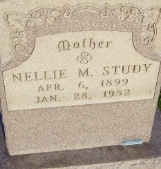

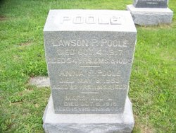
Nellie M. Poole Study
| Birth | : | 6 Apr 1899 Lantz, Frederick County, Maryland, USA |
| Death | : | 28 Jan 1952 Highfield, Washington County, Maryland, USA |
| Burial | : | Liverpool Naval Memorial, Liverpool, Metropolitan Borough of Liverpool, England |
| Coordinate | : | 53.4061220, -2.9981050 |
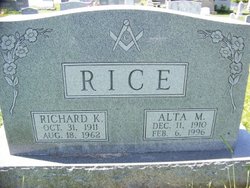
| Description | : | Mrs. Nellie M. Study, 52, wife of John Study, Pleasant Valley, died Monday, January 28, 1952, at the home of her sister, Mrs. Richard Rice, Highfield. She had been in failing health the past 26 years and was critically ill the last two weeks. She was discharged from the University Hospital, Baltimore, and had gone to the Rice home. She was born in Lantz, Md., a daughter of Lawson and Annie F.(Ott) Poole. She lived her early life in Lantz and Highfield and most of her married life in Carroll county. Mrs. Study was a member of the Reformed Church,... Read More |
frequently asked questions (FAQ):
-
Where is Nellie M. Poole Study's memorial?
Nellie M. Poole Study's memorial is located at: Liverpool Naval Memorial, Liverpool, Metropolitan Borough of Liverpool, England.
-
When did Nellie M. Poole Study death?
Nellie M. Poole Study death on 28 Jan 1952 in Highfield, Washington County, Maryland, USA
-
Where are the coordinates of the Nellie M. Poole Study's memorial?
Latitude: 53.4061220
Longitude: -2.9981050
Family Members:
Parent

Siblings

Flowers:


Nearby Cemetories:
1. St. Nicholas' Churchyard
Liverpool, Metropolitan Borough of Liverpool, England
Coordinate: 53.4069350, -2.9951480
2. St. George's Churchyard
Liverpool, Metropolitan Borough of Liverpool, England
Coordinate: 53.4049700, -2.9901030
3. St. Paul's Churchyard
Liverpool, Metropolitan Borough of Liverpool, England
Coordinate: 53.4099460, -2.9919370
4. St. Peter's Churchyard
Liverpool, Metropolitan Borough of Liverpool, England
Coordinate: 53.4051290, -2.9844200
5. St. Thomas Churchyard
Liverpool, Metropolitan Borough of Liverpool, England
Coordinate: 53.4010330, -2.9861190
6. St. John's Garden
Liverpool, Metropolitan Borough of Liverpool, England
Coordinate: 53.4087890, -2.9810070
7. Friends Burial Ground (Defunct)
Liverpool, Metropolitan Borough of Liverpool, England
Coordinate: 53.4111670, -2.9795830
8. Roscoe Memorial Gardens
Liverpool, Metropolitan Borough of Liverpool, England
Coordinate: 53.4044040, -2.9762180
9. St. Michaels Churchyard
Liverpool, Metropolitan Borough of Liverpool, England
Coordinate: 53.3976599, -2.9789353
10. Holy Trinity Churchyard
Liverpool, Metropolitan Borough of Liverpool, England
Coordinate: 53.4117490, -2.9759560
11. St. Anne's Churchyard
Liverpool, Metropolitan Borough of Liverpool, England
Coordinate: 53.4149050, -2.9782840
12. St. Andrew’s Churchyard
Liverpool, Metropolitan Borough of Liverpool, England
Coordinate: 53.4029730, -2.9726820
13. St Martin-in-the-Fields Churchyard
Liverpool, Metropolitan Borough of Liverpool, England
Coordinate: 53.4210110, -2.9877860
14. St Philip Graveyard
Liverpool, Metropolitan Borough of Liverpool, England
Coordinate: 53.4019240, -2.9719920
15. Liverpool Cathedral
Liverpool, Metropolitan Borough of Liverpool, England
Coordinate: 53.3974310, -2.9731610
16. Metropolitan Cathedral of Christ the King
Liverpool, Metropolitan Borough of Liverpool, England
Coordinate: 53.4052820, -2.9685940
17. St. James Churchyard
Toxteth, Metropolitan Borough of Liverpool, England
Coordinate: 53.3943720, -2.9750688
18. St. Mary's Churchyard
Birkenhead, Metropolitan Borough of Wirral, England
Coordinate: 53.3895930, -3.0112520
19. St Mary’s Parochial Cemetery
Liverpool, Metropolitan Borough of Liverpool, England
Coordinate: 53.4024370, -2.9672760
20. St James Garden Cemetery
Liverpool, Metropolitan Borough of Liverpool, England
Coordinate: 53.3960744, -2.9715005
21. Brunswick Chapel
Liverpool, Metropolitan Borough of Liverpool, England
Coordinate: 53.4111280, -2.9675500
22. St. Anthony's Churchyard
Liverpool, Metropolitan Borough of Liverpool, England
Coordinate: 53.4223190, -2.9815350
23. Wesleyan Methodist Chapel Graveyard
Liverpool, Metropolitan Borough of Liverpool, England
Coordinate: 53.3940590, -2.9719160
24. St. Werburgh & St. Laurence Catholic Churchyard
Birkenhead, Metropolitan Borough of Wirral, England
Coordinate: 53.3894910, -3.0217530