
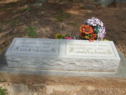
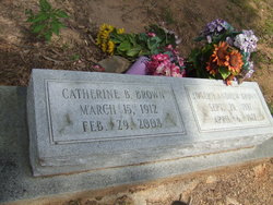
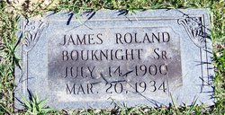
Nettie Catherine Bouknight Brown
| Birth | : | 15 Mar 1912 McCormick, McCormick County, South Carolina, USA |
| Death | : | 29 Feb 2008 Irmo, Lexington County, South Carolina, USA |
| Burial | : | Divide Cemetery, Groveland, Tuolumne County, USA |
| Coordinate | : | 37.8289300, -120.2439300 |
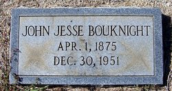
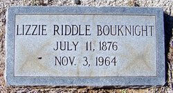
| Description | : | Catherine Bouknight Brown, 95, formerly of Cherry Street, McCormick, died peacefully February 29, 2008, 15 days shy of her 96th birthday. Born on March 15, 1912, she was the daughter of the late John Jesse Michael and Elizabeth Riddle Bouknight of the Dutch Fork section of Richland County. She graduated from Chapin High School in 1929, and the University of South Carolina in 1933. She also attended Summerland College. She played forward on the girls basketball team at Carolina and majored in English. She began teaching at Steedman School and learned to play the guitar there. She also taught in Red Bank and... Read More |
frequently asked questions (FAQ):
-
Where is Nettie Catherine Bouknight Brown's memorial?
Nettie Catherine Bouknight Brown's memorial is located at: Divide Cemetery, Groveland, Tuolumne County, USA.
-
When did Nettie Catherine Bouknight Brown death?
Nettie Catherine Bouknight Brown death on 29 Feb 2008 in Irmo, Lexington County, South Carolina, USA
-
Where are the coordinates of the Nettie Catherine Bouknight Brown's memorial?
Latitude: 37.8289300
Longitude: -120.2439300
Family Members:
Parent
Spouse

Siblings
Flowers:


Nearby Cemetories:
1. Divide Cemetery
Groveland, Tuolumne County, USA
Coordinate: 37.8289300, -120.2439300
2. Our Lady of Mount Carmel Cemetery
Big Oak Flat, Tuolumne County, USA
Coordinate: 37.8261584, -120.2550170
3. Citizens Cemetery
Big Oak Flat, Tuolumne County, USA
Coordinate: 37.8244470, -120.2588490
4. Morgan Chapel Cemetery
Tuolumne County, USA
Coordinate: 37.9265200, -120.3143000
5. Granite Spring Cemetery
Mariposa County, USA
Coordinate: 37.7210999, -120.3047028
6. Sturdevant Ranch Cemetery
Granite Springs, Mariposa County, USA
Coordinate: 37.7178000, -120.2970000
7. Coulterville Public Cemetery
Coulterville, Mariposa County, USA
Coordinate: 37.7159119, -120.1961365
8. Dudley Cemetery
Greeley Hill, Mariposa County, USA
Coordinate: 37.7534400, -120.1099700
9. Carters Cemetery
Tuolumne, Tuolumne County, USA
Coordinate: 37.9684550, -120.2359550
10. Cherokee Cemetery
Tuolumne, Tuolumne County, USA
Coordinate: 37.9783040, -120.2469060
11. Chinese Camp Cemetery
Chinese Camp, Tuolumne County, USA
Coordinate: 37.8726800, -120.4267700
12. Saint Xavier Catholic Cemetery
Chinese Camp, Tuolumne County, USA
Coordinate: 37.8704900, -120.4295200
13. Chinese Camp Odd Fellows Cemetery
Chinese Camp, Tuolumne County, USA
Coordinate: 37.8698000, -120.4311800
14. Landers Cemetery
Soulsbyville, Tuolumne County, USA
Coordinate: 37.9847730, -120.2663090
15. Stent Cemetery
Stent, Tuolumne County, USA
Coordinate: 37.9188300, -120.4133600
16. Ballard Cemetery
Tuolumne County, USA
Coordinate: 37.8150400, -120.4508200
17. Tuolumne County Hospital Cemetery
Sonora, Tuolumne County, USA
Coordinate: 37.9742110, -120.3777390
18. Montezuma Cemetery
Tuolumne County, USA
Coordinate: 37.9054600, -120.4537800
19. Sonora Odd Fellows Cemetery
Sonora, Tuolumne County, USA
Coordinate: 37.9771000, -120.3818000
20. Sonora Masonic Cemetery
Sonora, Tuolumne County, USA
Coordinate: 37.9804000, -120.3788800
21. Jamestown Cemetery
Jamestown, Tuolumne County, USA
Coordinate: 37.9466000, -120.4255000
22. Saint James Catholic Cemetery
Jamestown, Tuolumne County, USA
Coordinate: 37.9510000, -120.4230000
23. Mountain Shadow Cemetery
Sonora, Tuolumne County, USA
Coordinate: 37.9897300, -120.3690100
24. Saint Patricks Catholic Mountain View Cemetery
Sonora, Tuolumne County, USA
Coordinate: 37.9903100, -120.3690500