

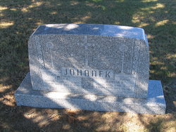
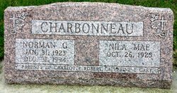
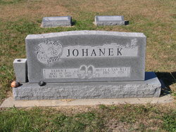
Nila Mae Johanek Charbonneau
| Birth | : | 26 Oct 1925 Esbon, Jewell County, Kansas, USA |
| Death | : | 28 Aug 2018 Concordia, Cloud County, Kansas, USA |
| Burial | : | Brown Cemetery, Donegal Township, Westmoreland County, USA |
| Coordinate | : | 40.1016998, -79.4064026 |
| Description | : | Chaput-Buoy Funeral Home Nila Mae Charbonneau, age 92, entered into rest on Tuesday, August 28, 2018 at Mt. Joseph Senior Village, Concordia, KS. She was born on October 26, 1925 in Esbon, Kansas to Martin and Edith (Pittsenbarger) Johanek. She was a 1943 graduate of Esbon High School. She then attended a Nurses training program in Concordia, where she received her RN Degree. She married Norman Gerard Charbonneau in Esbon, Kansas by Fr. Barrins. Norman preceded her in death on December 31, 1994. Both have lived in Concordia since 1944. She was a member of... Read More |
frequently asked questions (FAQ):
-
Where is Nila Mae Johanek Charbonneau's memorial?
Nila Mae Johanek Charbonneau's memorial is located at: Brown Cemetery, Donegal Township, Westmoreland County, USA.
-
When did Nila Mae Johanek Charbonneau death?
Nila Mae Johanek Charbonneau death on 28 Aug 2018 in Concordia, Cloud County, Kansas, USA
-
Where are the coordinates of the Nila Mae Johanek Charbonneau's memorial?
Latitude: 40.1016998
Longitude: -79.4064026
Family Members:
Parent

Spouse
Siblings


Children
Flowers:


Nearby Cemetories:
1. Brown Cemetery
Donegal Township, Westmoreland County, USA
Coordinate: 40.1016998, -79.4064026
2. Keslar Cemetery
Fayette County, USA
Coordinate: 40.0995100, -79.4145100
3. Donegal Cemetery
Donegal, Westmoreland County, USA
Coordinate: 40.1112000, -79.3785000
4. Hays Cemetery
Mount Pleasant, Westmoreland County, USA
Coordinate: 40.1259000, -79.4021000
5. Walnut Hill Cemetery
Donegal, Westmoreland County, USA
Coordinate: 40.1040000, -79.3659000
6. Eutsey Cemetery Old
Fayette County, USA
Coordinate: 40.0781400, -79.4427900
7. Porch Cemetery
Donegal, Westmoreland County, USA
Coordinate: 40.1306000, -79.3711014
8. Byerly Freeman Cemetery
Mount Pleasant, Westmoreland County, USA
Coordinate: 40.1432500, -79.4100900
9. Eutsey Cemetery
Fayette County, USA
Coordinate: 40.0742400, -79.4474900
10. Melcroft Cemetery
Fayette County, USA
Coordinate: 40.0561000, -79.3829000
11. Knopsnider Cemetery New
Bullskin Township, Fayette County, USA
Coordinate: 40.0685400, -79.4686800
12. Knopsnider Cemetery (Old)
Bullskin Township, Fayette County, USA
Coordinate: 40.0691400, -79.4704800
13. Stouffer Cemetery
Bullskin Township, Fayette County, USA
Coordinate: 40.0848990, -79.4816900
14. Saint Raymonds Cemetery
Melcroft, Fayette County, USA
Coordinate: 40.0572014, -79.3531036
15. Mount Nebo Cemetery
Indian Head, Fayette County, USA
Coordinate: 40.0531000, -79.3556000
16. Dan Snyder Cemetery
Fayette County, USA
Coordinate: 40.0408000, -79.4317000
17. Mellinger Cemetery
Mellingertown, Westmoreland County, USA
Coordinate: 40.1432050, -79.4784730
18. Nicholson Cemetery
Clinton, Fayette County, USA
Coordinate: 40.0506100, -79.4745600
19. Good Hope Lutheran Cemetery
Fayette County, USA
Coordinate: 40.0282000, -79.3893900
20. Lobingier Cemetery
Mount Pleasant Township, Westmoreland County, USA
Coordinate: 40.1439030, -79.4887870
21. Franklin Lutheran Cemetery
Kregar, Westmoreland County, USA
Coordinate: 40.1215000, -79.3085000
22. Sparks Cemetery
Indian Head, Fayette County, USA
Coordinate: 40.0239200, -79.3892500
23. Brothers Cemetery
Fayette County, USA
Coordinate: 40.1360700, -79.5004300
24. Fairview Cemetery
Kecksburg, Westmoreland County, USA
Coordinate: 40.1696000, -79.4634000