
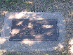
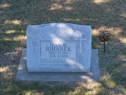
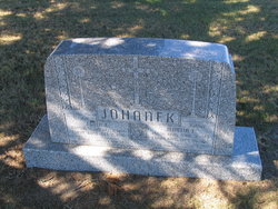
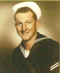
Ivan Martin Johanek
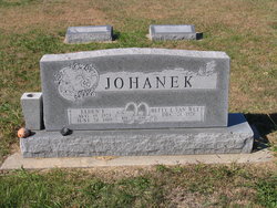
| Birth | : | 27 Nov 1915 Esbon, Jewell County, Kansas, USA |
| Death | : | 8 Nov 1989 Esbon, Jewell County, Kansas, USA |
| Burial | : | Whenua Tapu Cemetery, Porirua, Porirua City, New Zealand |
| Coordinate | : | -41.0550200, 174.8757150 |
| Plot | : | Block 3 Lot 8 |
| Inscription | : | CPL US ARMY WWII Son of Martin & Edith |
| Description | : | Salina Journal Friday, November 10, 1989 Ivan Martin Johanek ESBON — Ivan Martin Johanek, 73, rural Esbon, died Thursday, Nov. 9, 1989, at his home. Mr. Johanek was born Nov. 27, 1915, at Esbon and was a lifetime area resident. He was a farmer and a member of the Sacred Heart Catholic Church, Esbon. Survivors include a brother, Kenneth of Esbon; and four sisters, Nila Mae Charbonneau of Concordia, Janice Fief of Glasco, Velma Gouldie of Mankato and Thelma Beam of Esbon. The funeral will be 10:30 a.m. Saturday at the Sacred Heart Catholic Church, Esbon, Monsignor Vincent LeMoine officiating. Burial will be in... Read More |
frequently asked questions (FAQ):
-
Where is Ivan Martin Johanek's memorial?
Ivan Martin Johanek's memorial is located at: Whenua Tapu Cemetery, Porirua, Porirua City, New Zealand.
-
When did Ivan Martin Johanek death?
Ivan Martin Johanek death on 8 Nov 1989 in Esbon, Jewell County, Kansas, USA
-
Where are the coordinates of the Ivan Martin Johanek's memorial?
Latitude: -41.0550200
Longitude: 174.8757150
Family Members:
Parent

Siblings


Flowers:


Nearby Cemetories:
1. Whenua Tapu Cemetery
Porirua, Porirua City, New Zealand
Coordinate: -41.0550200, 174.8757150
2. Hongoeka Urupā
Plimmerton, Porirua City, New Zealand
Coordinate: -41.0651560, 174.8525070
3. Plimmerton Urupā
Plimmerton, Porirua City, New Zealand
Coordinate: -41.0822790, 174.8641890
4. Pukerua Bay Urupā
Pukerua Bay, Porirua City, New Zealand
Coordinate: -41.0300425, 174.8969530
5. Battle Hill Burial Ground
Wellington, Wellington City, New Zealand
Coordinate: -41.0578590, 174.9352810
6. Pauatahanui Burial Ground
Pauatahanui, Porirua City, New Zealand
Coordinate: -41.1068190, 174.9173310
7. Saint Albans Burial Ground
Pauatahanui, Porirua City, New Zealand
Coordinate: -41.1067240, 174.9179340
8. Bradey Grave
Whitby, Porirua City, New Zealand
Coordinate: -41.1173161, 174.9056161
9. St Josephs Catholic Cemetery
Pauatahanui, Porirua City, New Zealand
Coordinate: -41.1135060, 174.9196220
10. Mataiwhetu St Urupā
Takapuwahia, Porirua City, New Zealand
Coordinate: -41.1208070, 174.8364500
11. Takapu Urupā
Takapuwahia, Porirua City, New Zealand
Coordinate: -41.1203960, 174.8330360
12. Ngati Toa Street Urupā
Takapuwahia, Porirua City, New Zealand
Coordinate: -41.1264070, 174.8344310
13. Porirua Cemetery
Porirua, Porirua City, New Zealand
Coordinate: -41.1453640, 174.8420300
14. Mira Family Urupā
Paraparaumu, Kapiti Coast District, New Zealand
Coordinate: -40.9753380, 174.9643460
15. Tawa Flat Cemetery
Tawa, Wellington City, New Zealand
Coordinate: -41.1580600, 174.8281800
16. Grasslees Reserve
Tawa, Wellington City, New Zealand
Coordinate: -41.1647415, 174.8284302
17. MacKay Family Cemetery
Kapiti Coast District, New Zealand
Coordinate: -40.9726800, 174.9833330
18. Christ Church Anglican Cemetery
Taita, Lower Hutt City, New Zealand
Coordinate: -41.1820960, 174.9600920
19. St. John's Anglican Churchyard Cemetery
Trentham, Upper Hutt City, New Zealand
Coordinate: -41.1303100, 175.0443500
20. Taita Old Cemetery
Naenae, Lower Hutt City, New Zealand
Coordinate: -41.1945700, 174.9564000
21. Boulcott Farm Cemetery
Lower Hutt, Lower Hutt City, New Zealand
Coordinate: -41.2030590, 174.9272750
22. Knox Presbyterian Church Cemetery
Lower Hutt, Lower Hutt City, New Zealand
Coordinate: -41.1965430, 174.9579920
23. Taita Lawn Cemetery
Naenae, Lower Hutt City, New Zealand
Coordinate: -41.1968900, 174.9634900
24. Bridge Street Cemetery
Lower Hutt, Lower Hutt City, New Zealand
Coordinate: -41.2117740, 174.8969660