
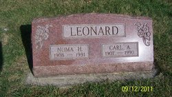
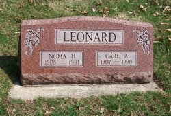
Noma Lavon Henderson Leonard
| Birth | : | 5 Apr 1908 Adrian, Bates County, Missouri, USA |
| Death | : | 21 May 1991 Newton, Jasper County, Iowa, USA |
| Burial | : | Liberty Cemetery, Ashland, Benton County, USA |
| Coordinate | : | 34.7881012, -89.2322006 |
| Description | : | Noma Lavon Henderson m- 21 February, 1930 in Colfax, Jasper County, Iowa Carl Avery Leonard Parents- Charles Malcom Henderson Maggie Alnora Curtis Children- Gene Avery Grace Lavon George Walter Carolyn Joyce |
frequently asked questions (FAQ):
-
Where is Noma Lavon Henderson Leonard's memorial?
Noma Lavon Henderson Leonard's memorial is located at: Liberty Cemetery, Ashland, Benton County, USA.
-
When did Noma Lavon Henderson Leonard death?
Noma Lavon Henderson Leonard death on 21 May 1991 in Newton, Jasper County, Iowa, USA
-
Where are the coordinates of the Noma Lavon Henderson Leonard's memorial?
Latitude: 34.7881012
Longitude: -89.2322006
Family Members:
Parent
Spouse
Siblings

Children
Flowers:


Nearby Cemetories:
1. Liberty Cemetery
Ashland, Benton County, USA
Coordinate: 34.7881012, -89.2322006
2. Bogard Cemetery
Benton County, USA
Coordinate: 34.8041992, -89.2466965
3. Beck Cemetery
Benton County, USA
Coordinate: 34.8107400, -89.2215100
4. Jordan Cemetery
Benton County, USA
Coordinate: 34.7661018, -89.2003021
5. Ayers Cemetery
Benton County, USA
Coordinate: 34.7602997, -89.2058029
6. Mount Zion CME Cemetery
Benton County, USA
Coordinate: 34.7994003, -89.2735977
7. Bluff Springs Cemetery
Ashland, Benton County, USA
Coordinate: 34.7722015, -89.1849976
8. South Ashland Church of Christ Cemetery
Ashland, Benton County, USA
Coordinate: 34.8145000, -89.1902100
9. Mount Zion Cemetery
Benton County, USA
Coordinate: 34.8125000, -89.2822037
10. Mitchell Cemetery
Benton County, USA
Coordinate: 34.8147011, -89.2817001
11. Shawnee Cemetery
Benton County, USA
Coordinate: 34.7705994, -89.2874985
12. Old Salem Cemetery
Benton County, USA
Coordinate: 34.8367000, -89.2282000
13. Royston Chapel C. M. E. Church Cemetery
Ashland, Benton County, USA
Coordinate: 34.7508550, -89.2803370
14. Asbury Cemetery
Ashland, Benton County, USA
Coordinate: 34.8278900, -89.1852400
15. McDonald Cemetery #3
Benton County, USA
Coordinate: 34.7646200, -89.1698670
16. Bains Chapel Cemetery
Ashland, Benton County, USA
Coordinate: 34.7505280, -89.1806133
17. Shiloh Cemetery
Ashland, Benton County, USA
Coordinate: 34.8283900, -89.1837100
18. Ayers-Ferrell Cemetery
Ashland, Benton County, USA
Coordinate: 34.8446000, -89.2166000
19. Harris Chapel Missionary Baptist Church Cemetery
Ashland, Benton County, USA
Coordinate: 34.8355400, -89.2727570
20. Governor Matthews Cemetery
Benton County, USA
Coordinate: 34.8418999, -89.2602997
21. Pleasant Hill Cemetery
Ashland, Benton County, USA
Coordinate: 34.7844009, -89.1577988
22. Hamer Cemetery
Benton County, USA
Coordinate: 34.8541985, -89.2414017
23. Lonoke Cemetery
Benton County, USA
Coordinate: 34.7228012, -89.2493973
24. Harmony Cemetery
Ashland, Benton County, USA
Coordinate: 34.7424730, -89.2916150