


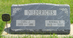
Norma Elizabeth Emma Foels Diederichs
| Birth | : | 26 Jan 1910 |
| Death | : | 2 Sep 2007 Harmony, Fillmore County, Minnesota, USA |
| Burial | : | Rose Hill Cemetery, Manson, Calhoun County, USA |
| Coordinate | : | 42.5228004, -94.5243988 |
| Description | : | HARMONY -- The funeral for Norma Diederichs will be at 1 p.m. Thursday at Greenfield Lutheran Church in Harmony. Interment will be in Postville Cemetery in Postville, Iowa. Mrs. Diederichs, 97, a longtime resident of Harmony, died Sunday (Sept. 2, 2007) at the Harmony Health Care Center. Norma Elizabeth Emma Foels was born Jan. 26, 1910, on a farm near Postville. She was married to Carl John Diederichs for 60 years; he died in May 1991. She and her husband moved to Harmony in 1937 and eventually bought two government granaries, from which they built their home. Mrs. Diederichs resided... Read More |
frequently asked questions (FAQ):
-
Where is Norma Elizabeth Emma Foels Diederichs's memorial?
Norma Elizabeth Emma Foels Diederichs's memorial is located at: Rose Hill Cemetery, Manson, Calhoun County, USA.
-
When did Norma Elizabeth Emma Foels Diederichs death?
Norma Elizabeth Emma Foels Diederichs death on 2 Sep 2007 in Harmony, Fillmore County, Minnesota, USA
-
Where are the coordinates of the Norma Elizabeth Emma Foels Diederichs's memorial?
Latitude: 42.5228004
Longitude: -94.5243988
Family Members:
Parent
Spouse
Siblings
Flowers:


Nearby Cemetories:
1. Rose Hill Cemetery
Manson, Calhoun County, USA
Coordinate: 42.5228004, -94.5243988
2. Saint Thomas Cemetery
Manson, Calhoun County, USA
Coordinate: 42.5208500, -94.5365000
3. Hope Cemetery
Manson, Calhoun County, USA
Coordinate: 42.4994011, -94.5199966
4. Saint Paul Lutheran Cemetery
Pocahontas County, USA
Coordinate: 42.5610000, -94.5392000
5. Leith Cemetery
Manson, Calhoun County, USA
Coordinate: 42.4878006, -94.5667038
6. Swedish Cemetery
Manson, Calhoun County, USA
Coordinate: 42.5426295, -94.5992013
7. Trinity Cemetery
Calhoun County, USA
Coordinate: 42.4747200, -94.4555588
8. Memorial Park Cemetery
Calhoun County, USA
Coordinate: 42.5189018, -94.6194000
9. Lizard Cemetery
Palmer, Pocahontas County, USA
Coordinate: 42.5875015, -94.4796982
10. Greenfield Cemetery
Knierim, Calhoun County, USA
Coordinate: 42.4495000, -94.4565000
11. Saint Patricks Cemetery
Clare, Webster County, USA
Coordinate: 42.5943985, -94.4419022
12. Saint Johns Lutheran Cemetery
Palmer, Pocahontas County, USA
Coordinate: 42.6268997, -94.5205994
13. Palmer Cemetery
Palmer, Pocahontas County, USA
Coordinate: 42.6166992, -94.5894012
14. Saint Paul Lutheran Cemetery
Palmer, Pocahontas County, USA
Coordinate: 42.6176000, -94.5893500
15. Saint Josephs Cemetery
Barnum, Webster County, USA
Coordinate: 42.5172000, -94.3769000
16. Calvary Presbyterian Cemetery
Barnum, Webster County, USA
Coordinate: 42.4742810, -94.3835020
17. Union Cemetery
Pomeroy, Calhoun County, USA
Coordinate: 42.5539017, -94.6789017
18. Jackson Center Cemetery
Clare, Webster County, USA
Coordinate: 42.5783005, -94.3741989
19. Saint Marys Catholic Cemetery
Pomeroy, Calhoun County, USA
Coordinate: 42.5558014, -94.6889038
20. Saint James Cemetery
Clare, Webster County, USA
Coordinate: 42.5691986, -94.3644028
21. Saint Josephs Cemetery
Palmer, Pocahontas County, USA
Coordinate: 42.6342010, -94.6188965
22. Saint Francis Cemetery
Rockwell City, Calhoun County, USA
Coordinate: 42.4055000, -94.6127000
23. Rosehill Cemetery
Rockwell City, Calhoun County, USA
Coordinate: 42.4042015, -94.6128006
24. Reformatory Cemetery
Rockwell City, Calhoun County, USA
Coordinate: 42.3952570, -94.6038660