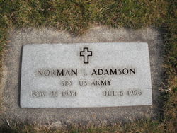
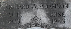
Norman L. Adamson
| Birth | : | 26 Nov 1934 Libby, Lincoln County, Montana, USA |
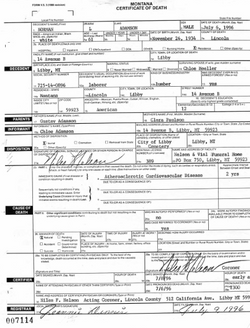
| Death | : | 6 Jul 1996 Libby, Lincoln County, Montana, USA |
| Burial | : | Red Hills Cemetery, Bushy Park, Derwent Valley Council, Australia |
| Coordinate | : | -42.7091350, 146.8893740 |
| Description | : | SP 3 US ARMY Montana, County Births and Deaths Name: Norman L Adamson Gender: Male Death Age: 61 Birth Date: 26 Nov 1934 Birth Place: Libby, Montana Death Date: 6 Jul 1996 Death Place: Libby, Lincoln, Montana Father: Gustav Adamson Mother: Clara Adamson Spouse: Chloe U.S., Department of Veterans Affairs BIRLS Death File Name: Norman Adamson Gender: Male Birth Date: 26 Nov 1934 Death Date: 6 Jul 1996 Branch 1: ARMY Enlistment Date 1: 23 Mar 1954 Release Date 1: 22 Mar 1956 Montana, Death Index |
frequently asked questions (FAQ):
-
Where is Norman L. Adamson's memorial?
Norman L. Adamson's memorial is located at: Red Hills Cemetery, Bushy Park, Derwent Valley Council, Australia.
-
When did Norman L. Adamson death?
Norman L. Adamson death on 6 Jul 1996 in Libby, Lincoln County, Montana, USA
-
Where are the coordinates of the Norman L. Adamson's memorial?
Latitude: -42.7091350
Longitude: 146.8893740
Family Members:
Parent
Siblings
Nearby Cemetories:
1. Red Hills Cemetery
Bushy Park, Derwent Valley Council, Australia
Coordinate: -42.7091350, 146.8893740
2. St. Mary's Church of England Cemetery
Gretna, Central Highlands Council, Australia
Coordinate: -42.6669200, 146.9333810
3. Plenty Anglican Church Cemetery
Plenty, Derwent Valley Council, Australia
Coordinate: -42.7382900, 146.9605860
4. Lawitta Church Cemetery
Magra, Derwent Valley Council, Australia
Coordinate: -42.7661690, 147.0331060
5. New Norfolk Old Cemetery
New Norfolk, Derwent Valley Council, Australia
Coordinate: -42.7719330, 147.0579860
6. St. Matthew’s Anglican Columbarium Wall
New Norfolk, Derwent Valley Council, Australia
Coordinate: -42.7792220, 147.0673080
7. Saint Matthew's Anglican Cemetery
New Norfolk, Derwent Valley Council, Australia
Coordinate: -42.7806289, 147.0664250
8. St. Stephen’s Catholic Church Cemetery
Hamilton, Central Highlands Council, Australia
Coordinate: -42.5624260, 146.8309980
9. St Colman’s Catholic Church Cemetery
Ellendale, Central Highlands Council, Australia
Coordinate: -42.6190180, 146.7164810
10. Tyenna General Cemetery
Tyenna, Derwent Valley Council, Australia
Coordinate: -42.7252550, 146.6749150
11. St. Peter's Church of England Cemetery
Hamilton, Central Highlands Council, Australia
Coordinate: -42.5541010, 146.8378730
12. St Andrews Church Cemetery
Ellendale, Central Highlands Council, Australia
Coordinate: -42.6097130, 146.7070010
13. Broadmarsh Congregational Cemetery
Broadmarsh, Southern Midlands Council, Australia
Coordinate: -42.6344620, 147.1129760
14. St. Augustine's Anglican Cemetery
Broadmarsh, Southern Midlands Council, Australia
Coordinate: -42.6380880, 147.1158740
15. Malbina General Cemetery
Malbina, Derwent Valley Council, Australia
Coordinate: -42.7866610, 147.1184830
16. St. James Anglican Church Cemetery
Hollow Tree, Central Highlands Council, Australia
Coordinate: -42.4708990, 146.8817810
17. Jackman Graveyard
Collinsvale, Glenorchy City, Australia
Coordinate: -42.8406720, 147.1639470
18. St. Mary's Anglican Cemetery
Bridgewater, Brighton Council, Australia
Coordinate: -42.7374010, 147.2282310
19. St. Michael's Anglican Cemetery
Bagdad, Southern Midlands Council, Australia
Coordinate: -42.6263790, 147.2226500
20. Saint John the Baptist Anglican Church Cemetery
Ouse, Central Highlands Council, Australia
Coordinate: -42.4848760, 146.7128530
21. Collinsvale Uniting Church Cemetery
Collinsvale, Glenorchy City, Australia
Coordinate: -42.8410560, 147.1991720
22. Immaculate Conception Catholic Church Cemetery
Ouse, Central Highlands Council, Australia
Coordinate: -42.4813800, 146.7072740
23. Bagdad Uniting Church Cemetery
Bagdad, Southern Midlands Council, Australia
Coordinate: -42.6084120, 147.2222760
24. Hestercombe Uniting Church Cemetery
Austins Ferry, Glenorchy City, Australia
Coordinate: -42.7695190, 147.2448030


