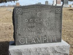
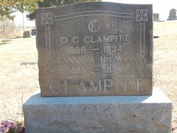
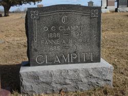
O. C. Clampitt
| Birth | : | 12 Sep 1886 Breckenridge, Hancock County, Illinois, USA |
| Death | : | 20 Jun 1924 Pleasanton, Decatur County, Iowa, USA |
| Burial | : | Emmanuel Churchyard, Holcombe, Metropolitan Borough of Bury, England |
| Coordinate | : | 53.6463000, -2.3293400 |
| Plot | : | 3 11-8 |
| Description | : | MArried Fannie Griffin on MArch 24, 1909. Adopted father of Reva Simpson. In 11m 2014 contributor Marilyn (#47077044) upgraded O.C.'s birthplace to Breckinridge, Hancock Co, Illinois from Hancock Co, Illinois and his place of death to Pleasanton, Hamilton Twsp, Decatur Co, Iowa from Decatur Co, Iowa. She also then added links to his parents. |
frequently asked questions (FAQ):
-
Where is O. C. Clampitt's memorial?
O. C. Clampitt's memorial is located at: Emmanuel Churchyard, Holcombe, Metropolitan Borough of Bury, England.
-
When did O. C. Clampitt death?
O. C. Clampitt death on 20 Jun 1924 in Pleasanton, Decatur County, Iowa, USA
-
Where are the coordinates of the O. C. Clampitt's memorial?
Latitude: 53.6463000
Longitude: -2.3293400
Family Members:
Parent
Spouse
Siblings
Flowers:
Nearby Cemetories:
1. Emmanuel Churchyard
Holcombe, Metropolitan Borough of Bury, England
Coordinate: 53.6463000, -2.3293400
2. Ramsbottom Cemetery
Ramsbottom, Metropolitan Borough of Bury, England
Coordinate: 53.6372986, -2.3271000
3. St. John-in-the-Wilderness Churchyard
Shuttleworth, Metropolitan Borough of Bury, England
Coordinate: 53.6556300, -2.3046500
4. St. John in the Wilderness Shuttleworrth
Walmersley, Metropolitan Borough of Bury, England
Coordinate: 53.6557090, -2.3037740
5. Stubbins Congregational Chapelyard
Rossendale Borough, England
Coordinate: 53.6626600, -2.3110700
6. Rowlands Methodist Churchyard
Summerseat, Metropolitan Borough of Bury, England
Coordinate: 53.6294360, -2.3102920
7. Greenmount United Reformed Churchyard
Greenmount, Metropolitan Borough of Bury, England
Coordinate: 53.6254581, -2.3381465
8. St Mary Churchyard
Hawkshaw, Metropolitan Borough of Bury, England
Coordinate: 53.6307270, -2.3636210
9. Hawkshaw Methodist Church Cemetery
Hawkshaw, Metropolitan Borough of Bury, England
Coordinate: 53.6313490, -2.3674190
10. St Anne Churchyard
Tottington, Metropolitan Borough of Bury, England
Coordinate: 53.6161499, -2.3409030
11. Edenfield Parish Churchyard
Ramsbottom, Metropolitan Borough of Bury, England
Coordinate: 53.6742799, -2.3069304
12. Park Chapel
Walmersley, Metropolitan Borough of Bury, England
Coordinate: 53.6205060, -2.2958590
13. St. John's Churchyard
Tottington, Metropolitan Borough of Bury, England
Coordinate: 53.6141180, -2.3400670
14. Christ Church Churchyard
Walmersley, Metropolitan Borough of Bury, England
Coordinate: 53.6193360, -2.2964630
15. Christ Church Churchyard
Bury, Metropolitan Borough of Bury, England
Coordinate: 53.6194570, -2.2960140
16. Congregational Churchyard
Affetside, Metropolitan Borough of Bury, England
Coordinate: 53.6175200, -2.3705800
17. Methodist Church Churchyard
Edgworth, Blackburn with Darwen Unitary Authority, England
Coordinate: 53.6424280, -2.3962830
18. Edgworth Congregational Chapelyard
Edgworth, Blackburn with Darwen Unitary Authority, England
Coordinate: 53.6476280, -2.3967210
19. Saint Thomas Churchyard
Helmshore, Rossendale Borough, England
Coordinate: 53.6870400, -2.3300000
20. St. Anne's Churchyard
Chapeltown, Blackburn with Darwen Unitary Authority, England
Coordinate: 53.6371710, -2.4030440
21. St. James Churchyard
Bury, Metropolitan Borough of Bury, England
Coordinate: 53.5996770, -2.3214600
22. All Saints Churchyard
Elton, Metropolitan Borough of Bury, England
Coordinate: 53.5965000, -2.3118000
23. Tottington Road Methodist Church Churchyard
Harwood, Metropolitan Borough of Bolton, England
Coordinate: 53.6079190, -2.3904960
24. Haslingden Cemetery
Haslingden, Rossendale Borough, England
Coordinate: 53.6989500, -2.3427700

