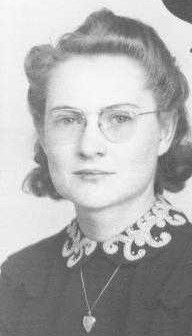
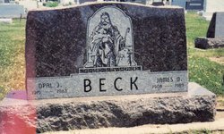
Opal Josephine Blades Beck
| Birth | : | 7 Aug 1919 Ottawa County, Kansas, USA |
| Death | : | 15 Sep 1983 Concordia, Cloud County, Kansas, USA |
| Burial | : | Mount Pisgah Cemetery, Thayer, Union County, USA |
| Coordinate | : | 41.0511017, -94.1007996 |
| Description | : | OBITUARY, The Glasco Sun, Glasco, Kansas Funeral services for Mrs. Opal J. Beck, 64, Glasco, were Saturday, Sept. 17, 1983, at 10:00 a.m. in the Christian Church, Glasco, Pastor Darrel Hoffmaster officiating. Opal (Blades) Beck was born Aug. 7, 1919, near Minneapolis, daughter of Samuel T. Blades and Sadie Maria Ayres, and died Sept. 15, 1983, at St. Joseph Hospital, Concordia. Opal was raised by Albert and Bessie Schur from age four. She graduated from Minneapolis High School in 1938. Following graduation, she moved to Glasco to work at Smejkal's Cafe where she met her husband, Jim O. Beck.... Read More |
frequently asked questions (FAQ):
-
Where is Opal Josephine Blades Beck's memorial?
Opal Josephine Blades Beck's memorial is located at: Mount Pisgah Cemetery, Thayer, Union County, USA.
-
When did Opal Josephine Blades Beck death?
Opal Josephine Blades Beck death on 15 Sep 1983 in Concordia, Cloud County, Kansas, USA
-
Where are the coordinates of the Opal Josephine Blades Beck's memorial?
Latitude: 41.0511017
Longitude: -94.1007996
Family Members:
Flowers:
Nearby Cemetories:
1. Mount Pisgah Cemetery
Thayer, Union County, USA
Coordinate: 41.0511017, -94.1007996
2. Browns Mountain Cemetery
Thayer, Union County, USA
Coordinate: 41.0499992, -94.0999985
3. Beulah Cemetery
Thayer, Union County, USA
Coordinate: 41.0589981, -94.0759964
4. Bethel Cemetery
Thayer, Union County, USA
Coordinate: 41.0600014, -94.0693970
5. Monette Cemetery
Lorimor, Union County, USA
Coordinate: 41.0800743, -94.0715866
6. West Union Cemetery
Thayer, Union County, USA
Coordinate: 41.0191994, -94.0721970
7. Thayer Catholic Cemetery
Thayer, Union County, USA
Coordinate: 41.0374985, -94.0357971
8. Otterbein Cemetery
Thayer, Union County, USA
Coordinate: 40.9990005, -94.0879974
9. Norris Plot Cemetery
Afton, Union County, USA
Coordinate: 41.0079994, -94.1579971
10. Groesbeck Cemetery
Lorimor, Union County, USA
Coordinate: 41.1100006, -94.1230011
11. Claypool Cemetery
Thayer, Union County, USA
Coordinate: 41.0126114, -94.0303497
12. Greenlawn Cemetery
Afton, Union County, USA
Coordinate: 41.0335999, -94.1856003
13. Lorimor Cemetery
Lorimor, Union County, USA
Coordinate: 41.1128006, -94.0516968
14. Civil War Era Cemetery
Afton, Union County, USA
Coordinate: 41.0460854, -94.2025299
15. Abel Cemetery
Arispe, Union County, USA
Coordinate: 40.9790001, -94.1429977
16. Bragg Cemetery
Lorimor, Union County, USA
Coordinate: 41.1282997, -94.1433029
17. Saint Edwards Catholic Cemetery
Afton, Union County, USA
Coordinate: 41.0359993, -94.2129974
18. Dodge Center Cemetery
Afton, Union County, USA
Coordinate: 41.1279984, -94.1829987
19. Olinger Cemetery
Union County, USA
Coordinate: 40.9690208, -94.0274887
20. Rollins Plot Cemetery
Afton, Union County, USA
Coordinate: 41.0040283, -94.2234802
21. Cedar Grove Cemetery
Lorimor, Union County, USA
Coordinate: 41.1209984, -94.2200012
22. Murray Cemetery
Murray, Clarke County, USA
Coordinate: 41.0278015, -93.9456024
23. County Home Cemetery
Creston, Union County, USA
Coordinate: 41.0449982, -94.2590027
24. Barney Cemetery
Monroe Township, Madison County, USA
Coordinate: 41.1641998, -94.0239029


