
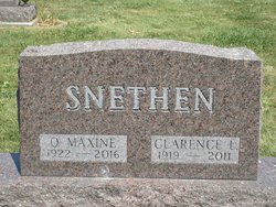
Opal Maxine Todd Snethen
| Birth | : | 28 May 1922 Harrison County, Missouri, USA |
| Death | : | 20 Jan 2016 Omaha, Douglas County, Nebraska, USA |
| Burial | : | Rose Hill Cemetery, Lamoni, Decatur County, USA |
| Coordinate | : | 40.6250000, -93.9475021 |
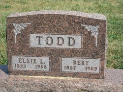
| Description | : | Opal Maxine Snethen May 28, 1922 - January 20, 2016 Opal Maxine (Todd) Snethen was born at home to Bert and Elsie (Marshall) Todd in Harrison County, Missouri. She graduated from Smith Country School in Decatur County, Iowa. After completing school she helped her parents in the home and on the farm. Arranged through a blind date, she met Clarence Leroy Snethen and they dated through WWII using gas ration coupons for his truck. They were married September 3, 1944, and were married 67 years at the time of Clarence’s passing, having lived all of their married life in... Read More |
frequently asked questions (FAQ):
-
Where is Opal Maxine Todd Snethen's memorial?
Opal Maxine Todd Snethen's memorial is located at: Rose Hill Cemetery, Lamoni, Decatur County, USA.
-
When did Opal Maxine Todd Snethen death?
Opal Maxine Todd Snethen death on 20 Jan 2016 in Omaha, Douglas County, Nebraska, USA
-
Where are the coordinates of the Opal Maxine Todd Snethen's memorial?
Latitude: 40.6250000
Longitude: -93.9475021
Family Members:
Parent

Spouse
Flowers:


Nearby Cemetories:
1. Rose Hill Cemetery
Lamoni, Decatur County, USA
Coordinate: 40.6250000, -93.9475021
2. Sweet Home Cemetery
Fayette Township, Decatur County, USA
Coordinate: 40.5946550, -93.9566660
3. Lillie Cemetery
Lamoni, Decatur County, USA
Coordinate: 40.6565829, -93.9418602
4. Creveling Cemetery
Lamoni, Decatur County, USA
Coordinate: 40.6309232, -93.8984728
5. Hollen Cemetery
Lamoni, Decatur County, USA
Coordinate: 40.5952000, -94.0097000
6. Lewis Cemetery
Kellerton, Ringgold County, USA
Coordinate: 40.6588500, -94.0280500
7. Andover Cemetery
Andover, Harrison County, USA
Coordinate: 40.5588989, -93.9008026
8. Terre Haute Cemetery
Terre Haute, Decatur County, USA
Coordinate: 40.6836646, -93.8800621
9. Bucy Cemetery
Decatur City, Decatur County, USA
Coordinate: 40.6902056, -93.8869286
10. New Buda Cemetery
Davis City, Decatur County, USA
Coordinate: 40.6027448, -93.8314819
11. Patrick Cemetery
Riley Township, Ringgold County, USA
Coordinate: 40.5900000, -94.0586000
12. Downey Cemetery
Harrison County, USA
Coordinate: 40.5581017, -93.8606033
13. Elk Cemetery
Lamoni, Decatur County, USA
Coordinate: 40.7210467, -93.9390707
14. Mount Zion Cemetery
Riley Township, Ringgold County, USA
Coordinate: 40.5960000, -94.0731000
15. IOOF Cemetery
Davis City, Decatur County, USA
Coordinate: 40.6405800, -93.8174600
16. Miller Cemetery
Decatur County, USA
Coordinate: 40.7026000, -93.8592000
17. Anderson Cemetery
Eagleville, Harrison County, USA
Coordinate: 40.5293503, -93.9983292
18. Mount Pleasant No 2 Baptist Church Cemetery
Blythedale, Harrison County, USA
Coordinate: 40.5300010, -93.8916160
19. Old Davis City Cemetery
Davis City, Decatur County, USA
Coordinate: 40.6415100, -93.8115800
20. Brown Cemetery
Eagleville, Harrison County, USA
Coordinate: 40.5447006, -94.0357971
21. Millsap Cemetery
Grand River, Decatur County, USA
Coordinate: 40.7333310, -93.9502260
22. Maple Row Cemetery
Kellerton, Ringgold County, USA
Coordinate: 40.7077700, -94.0424500
23. Catholic Cemetery
Harrison County, USA
Coordinate: 40.5522003, -93.8380966
24. Payne Cemetery
Hatfield, Harrison County, USA
Coordinate: 40.5592003, -94.0733032