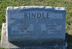
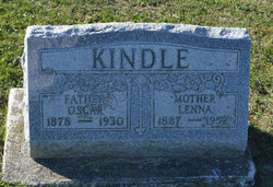
Oscar Kindle
| Birth | : | 1880 Allen County, Ohio, USA |
| Death | : | 11 May 1930 Hardin County, Ohio, USA |
| Burial | : | All Hallows Graveyard, Wallingford, South Oxfordshire District, England |
| Coordinate | : | 51.6020520, -1.1242267 |
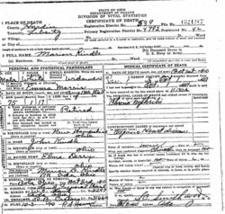
| Description | : | Rites Conducted For Dola Accident Victim KENTON, May 13 - Funeral services for Oscar Kindle, 52, farmer of near Dola, who died a few minutes after he was hurled thru the windshield of an automobile west of here from a severed jugular vein, were held Tuesday afternoon from the Eagle Creek Dunkard church in charge of Rev. Mr. Anglemeyer. Burial in the Dola cemetery. The mishap occurred when Kindle asked Cliff Henkle, 45, driver of the car, for a match and the machine crashed into a ditch. Coroner D. Emmett Johnson rendered a verdict of accidental death. The widow, three sons,... Read More |
frequently asked questions (FAQ):
-
Where is Oscar Kindle's memorial?
Oscar Kindle's memorial is located at: All Hallows Graveyard, Wallingford, South Oxfordshire District, England.
-
When did Oscar Kindle death?
Oscar Kindle death on 11 May 1930 in Hardin County, Ohio, USA
-
Where are the coordinates of the Oscar Kindle's memorial?
Latitude: 51.6020520
Longitude: -1.1242267
Family Members:
Parent
Spouse
Siblings
Flowers:
Nearby Cemetories:
1. All Hallows Graveyard
Wallingford, South Oxfordshire District, England
Coordinate: 51.6020520, -1.1242267
2. Saint Peter's Churchyard
Wallingford, South Oxfordshire District, England
Coordinate: 51.6005819, -1.1215970
3. St. Mary-le-More Churchyard
Wallingford, South Oxfordshire District, England
Coordinate: 51.5993878, -1.1249488
4. Wallingford Cemetery
Wallingford, South Oxfordshire District, England
Coordinate: 51.6058200, -1.1232000
5. St. Leonard's Churchyard
Wallingford, South Oxfordshire District, England
Coordinate: 51.5972711, -1.1230712
6. St Mary Magdalene Churchyard
Crowmarsh Gifford, South Oxfordshire District, England
Coordinate: 51.5992169, -1.1139564
7. St. John the Baptist Church (Defunct)
Mongwell, South Oxfordshire District, England
Coordinate: 51.5860980, -1.1233580
8. St. Helen's Churchyard
Benson, South Oxfordshire District, England
Coordinate: 51.6200200, -1.1127400
9. St. Helen Churchyard Extension
Benson, South Oxfordshire District, England
Coordinate: 51.6201400, -1.1121200
10. Benson War Memorial
Benson, South Oxfordshire District, England
Coordinate: 51.6207890, -1.1108700
11. Saint James Churchyard
Brightwell cum Sotwell, South Oxfordshire District, England
Coordinate: 51.6120200, -1.1549800
12. St. Agatha New Churchyard
Brightwell cum Sotwell, South Oxfordshire District, England
Coordinate: 51.6131480, -1.1665480
13. St. Mary's Churchyard
North Stoke, South Oxfordshire District, England
Coordinate: 51.5714910, -1.1228080
14. St. Mary's Churchyard
Cholsey, South Oxfordshire District, England
Coordinate: 51.5788078, -1.1589500
15. Friends Burying Ground
Warborough, South Oxfordshire District, England
Coordinate: 51.6374080, -1.1354510
16. St Laurence Churchyard
Warborough, South Oxfordshire District, England
Coordinate: 51.6383330, -1.1358310
17. St. Mary the Virgin Churchyard
Ewelme, South Oxfordshire District, England
Coordinate: 51.6177310, -1.0674850
18. All Saints Churchyard
North Moreton, South Oxfordshire District, England
Coordinate: 51.6021922, -1.1898247
19. St. Mary the Virgin Cemetery
Ipsden, South Oxfordshire District, England
Coordinate: 51.5674164, -1.0866686
20. St. John the Baptist South Moreton
South Moreton, South Oxfordshire District, England
Coordinate: 51.5881630, -1.1895850
21. South Moreton Strict Baptist Chapel
South Moreton, South Oxfordshire District, England
Coordinate: 51.5900300, -1.1924310
22. Saint Birinus Catholic Churchyard
Dorchester, South Oxfordshire District, England
Coordinate: 51.6412600, -1.1649100
23. Dorchester Abbey
Dorchester, South Oxfordshire District, England
Coordinate: 51.6436250, -1.1644290
24. St. Peter's Churchyard
Little Wittenham, South Oxfordshire District, England
Coordinate: 51.6369880, -1.1830625

